

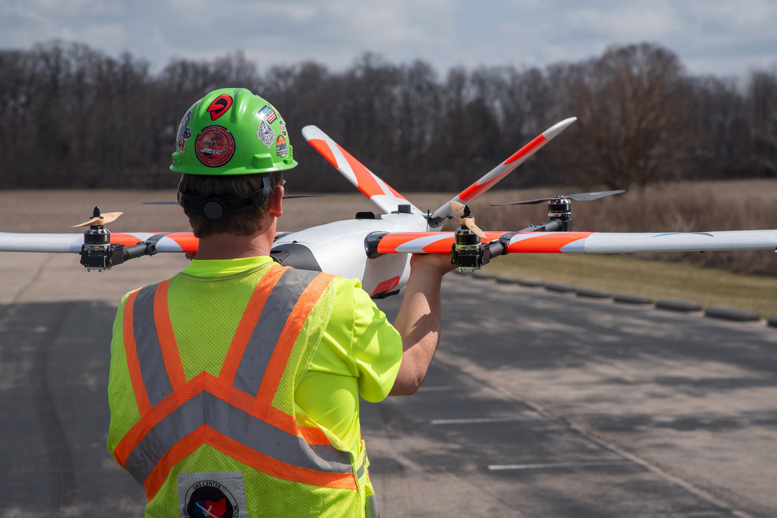
Recent news about the Ohio Department of Transportation’s plans to fly a large drone over a stretch of highway outside Columbus caught the attention of stakeholders across the drone industry. The 20-pound Censys Sentaero drone is large, but the information it’s set to capture around how the technology can be utilized to support traffic monitoring and incident management is set to be even bigger.
While this is the first of its size in the country to be approved for that specific purpose, it’s far from a first for the Ohio Department of Transportation (ODOT) with its use of drone technology. Formed in 2013, the Ohio UAS Center manages and performs all uncrewed aircraft operations for ODOT, which have taken place on projects of all types for over a decade.
Ohio has been a leader in advancing UAS technology but what lessons can others learn from their use of the technology? Could any of their insights be utilized for other applications of the technology? What’s next for their program? Answers to these questions highlight how the department is helping to define the future of aviation in and around Ohio as well as for entire industries.
Establishing and Expanding an Operational Footprint for Drones
From bridge inspections to building management, DOTs nationwide are embracing drones but ODOT has specifically proven how the technology creates value when compared to certain established processes and procedures. The ODOT team has previously made a case for their drone program’s return on investment, but the value they’ve enabled to enhance the safety of their crew and the general public have made a difference in a way that goes beyond the bottom line. Much of this stems from the creation of DriveOhio, which represents a dedicated effort by the department to best leverage the technology.
DriveOhio is the state's center for smart mobility and an essential part of ODOT. It combines smart mobility both on the ground and in the air and was created in anticipation of the needs associated with emerging transportation technology. It was intended to connect public and private entities that are focused on advanced air mobility technologies across Ohio, but the effort to connect these pieces goes beyond state borders. The team is focused on collaboration with other states and stakeholders to impact national policy, all of which contribute to a larger ecosystem that benefits everyone.
“What makes Ohio unique in this space is its collaborative nature,” said Rich Fox, director of the Ohio UAS Center. “We have military, government, private companies, and academia all working together to advance an industry, sharing lessons learned and new ideas. While we’ve certainly discovered innovative ways to apply this technology to our transportation system, it’s not limited to DOTs. In addition to supporting ODOT operations, another of our functions at the Ohio UAS Center is to assist other state agencies and local governments with establishing a UAS program.”
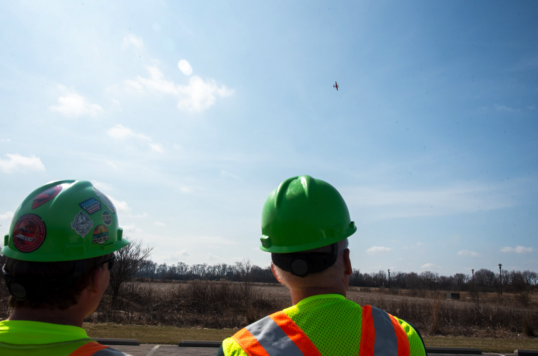
That kind of support comes from operations and tests like the one that is set to take place over a four-mile stretch of a highway northwest of Columbus, Ohio. The work the organization put in to receive permission from the FAA for the pilot traffic surveillance program is just as notable as the insights that it will capture. The department received special permission from FAA officials to fly the aircraft out of view of its on-the-ground pilot, and the importance of permission associated with these types of drone flights cannot be overstated.
The flight will be conducted across a stretch of highway that’s been referred to as a “Smart Mobility Corridor,” allowing ODOT and other organizations in DriveOhio to explore how drones and other innovative pieces of technology can create efficiencies in the present and future. Since it’s been referred to as one of the country’s premiere smart highways, does that mean insights from the pilot traffic surveillance program will only be applicable to similarly “smart” highways?
“While the approval includes a portion of U.S. 33, this effort is separate from the research project along the corridor that explored uncrewed traffic management (UTM),” Fox told Commercial UAV News. “Our goal with this approval is to grow our pilots’ expertise and demonstrate that we’ve developed robust operational and safety procedures so that we can submit additional waiver applications to potentially expand our operational footprint to more corridors in all parts of the state.”
More recent reporting about the program has further detailed exactly how the test will eventually make things safer for ODOT workers and for the general public. It’s an illustration of how the data and insights from this flight might be utilized in bigger and different ways, but as Fox mentioned in the original news, these developments are only the beginning of where and how drone technology will change things for the better.
Utilizing UAS Today, Improving the Flow of Traffic Tomorrow
Those future opportunities can be applied by a wide range of professionals, which include bridge inspectors, surveyors, engineers, construction project managers, and more. That range goes in multiple directions though, as Fox mentioned that while drones have become an invaluable resource for his team, the growth potential that he sees for the technology spans across the state and country.
“As drone technology and regulations continue to advance, ODOT hopes to leverage this training and experience for widespread BVLOS operations in the future, which would be a game changer, particularly for incident response and emergency management,” Fox further explained. “The potential ability to deploy a drone remotely from any facility throughout the state would allow crews to quickly gather real-time information at the scene of a crash, cover a large area to survey damage or aide search and rescue, and much more. This is the first step towards unlocking endless potential.”
That endless potential is something DOTs across the country are embracing, while teams all over the world are using the technology to scan, fly and model various pieces of infrastructure, enabling the creation of models that allow stakeholders to take accurate distance, area and volume measurements. It’s an example of the difference drone technology can make for an agency’s operations, but the potential to expand these operational footprints beyond line-of-sight flights represents a whole new set of opportunities.
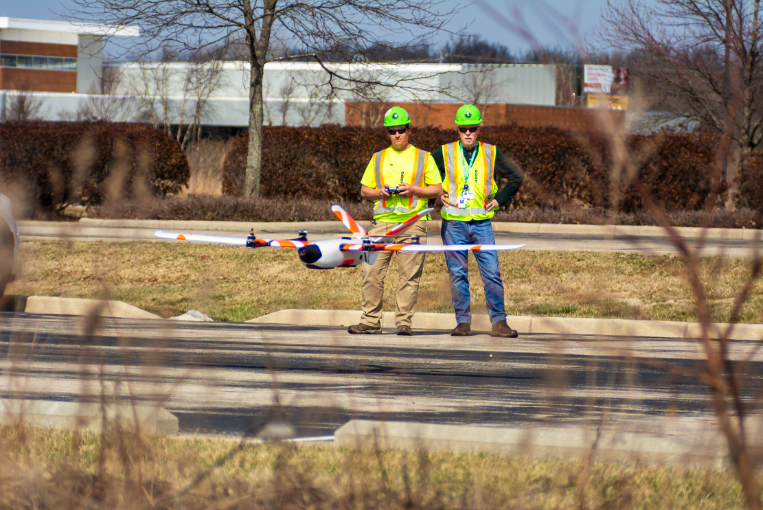
In order to best plan for the eventual reality of BVLOS operations, ODOT has added a dozen drone pilots to their arsenal across the state over the past year. Their aim is to continue growing that number of pilots, but they’re also thinking of the many different ways the technology will be utilized in the short and long term.
“Short term, we’re always looking for new ways to utilize UAS to support ODOT’s maintenance operations,” Fox said. “A couple applications we’re looking into include sprayer drones to mitigate vegetation in hard-to-reach areas as well as underwater vehicles that may be able to assist with bridge inspections and construction monitoring. Years from now, we see this technology as a way to improve safety on the ground by identifying congestion and other hazards, which would then trigger our crews to make adjustments both remotely and in the field to improve traffic flow and reduce crashes.”
The ODOT team is also preparing for the anticipated Part 108 certification for Beyond Visual Line of Sight by working with Sinclair Community College to design a new training program. They’re also expending their fleet with fixed wing eVTOLs to support applications and projects associated with these expanded operational capacities.
For DOTs and other teams looking to utilize drones in similar ways to improve efficiencies and lower risk to workers, getting there means a commitment to establishing systematic procedures, practices, and policies for the management of safety risk. That approach helped ODOT receive FAA approval to fly a 20-pound drone with a wingspan of 7½ feet, highlighting what a commitment to creating value with the technology can mean in the present and for the future.

.jpg.small.400x400.jpg)


Comments