

This is Part 2 of a multipart series. Check out Part 1: "Powering Solutions for Your Drone, Part 1: What's Out There?" here.
What's the Big Deal with Drone Power?
Why are longer flight times, flying farther, and higher payload capacity such a major topic for commercial drone manufacturers? Is it just a case of making a flashier drone—like advertising your car can reach 200 miles per hour when you know most drivers will only ever be allowed to go up to 80 mph? Or is there something more to it?
Let’s spare the suspense: there is a lot more to it, and how we address these issues will determine how and what industries will move forward with drone technology.
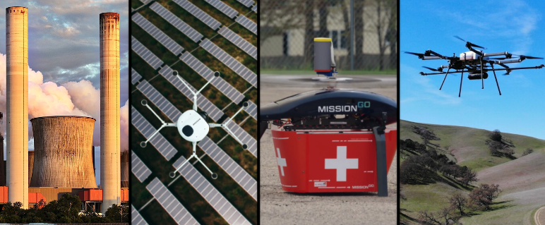
The more a drone can take on the responsibilities of expensive, high-carbon-emitting aircraft and vehicles, like helicopters, the broader their utility will be for commercial markets. Larger transportation devices already have a known use case for these commercial markets so making the switch to a lighter, cheaper, carbon-friendly alternative is an attractive and compelling use case for many verticals like energy and utilities, delivery, agriculture and forestry, and more.
This is not a new revelation. The case for drones being a replacement for heavier aircraft and vehicles has been made for many years now, so why haven’t we just made the switch to drones? We are quick to say regulations are the major roadblock, and to some extent they are, but other things like public acceptance and demand, and power continue to be challenges as well. Mainstream commercial UAVs have limitations when it comes to flight times and distance, operating in challenging weather conditions, or carrying high payloads. The bulk of commercial UAVs are really used for lightweight, short duration data collection where operations stay within visual line of sight and can easily be done within Part 107. But there is a growing demand and interest in applications outside of this narrow set of parameters that require longer flight times, heavier payloads, and operations in more extreme conditions. This is a largely under tapped market for drones.
Endurance (how long a drone can stay up in the air), range (how far it can travel), payload capacity (how much weight it can carry), and weather resistance (withstanding wind, rain, snowfall, and very high and low ambient temperatures) are challenging factors for those who are looking to take on these complex jobs. For example, if a drone can fly for 4 hours but can only carry one lightweight sensor and can only fly in perfect weather conditions these specifications probably wouldn’t help a company looking to replace an expensive helicopter that carries multiple sensors to follow miles of pipeline in northern Alaska.
Drone manufacturers need to address all these aspects to begin to compete with traditional methods, but once they do and can demonstrate this effectively, this opens up a whole new range of opportunities for the drone industry.
To illustrate what all of this can mean for the industry, we've connected with several companies that are tackling endurance, range, payload capacity, and weather resistance head on. We asked them for their take on why we need to keep pushing the envelope on battery solutions and to provide examples of how they are providing value today and can provide value in the future. Check out their compelling stories below.
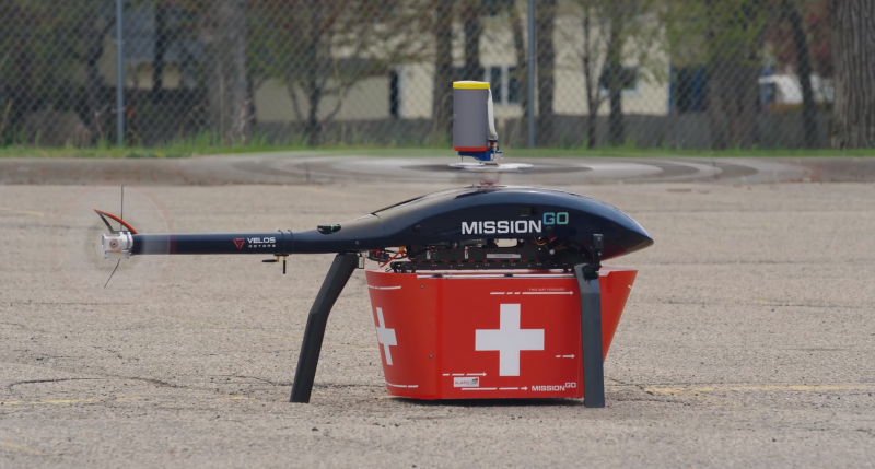
The Payload Logistics of Organ Transportation with MissionGO
 “Calculating the tradeoff between weight and payload has been the fundamental question since the beginning of aviation.” Anthony Pucciarella, President of MissionGO.
Transporting an organ is a race against time. Once a viable organ is ready, it is limited by how quickly it can be prepared and sent out for delivery, and how far it can go before it is no longer viable. Ground transportation in particular can be unpredictable; there’s never a guarantee that there won’t be a traffic jam or incident. MissionGO’s unmanned aircraft solutions company is working on getting organs to the people who need them faster and more reliably by taking to the air. To accomplish this there was a surprising number of logistical issues they had to figure out, especially in regard to payload capacity.
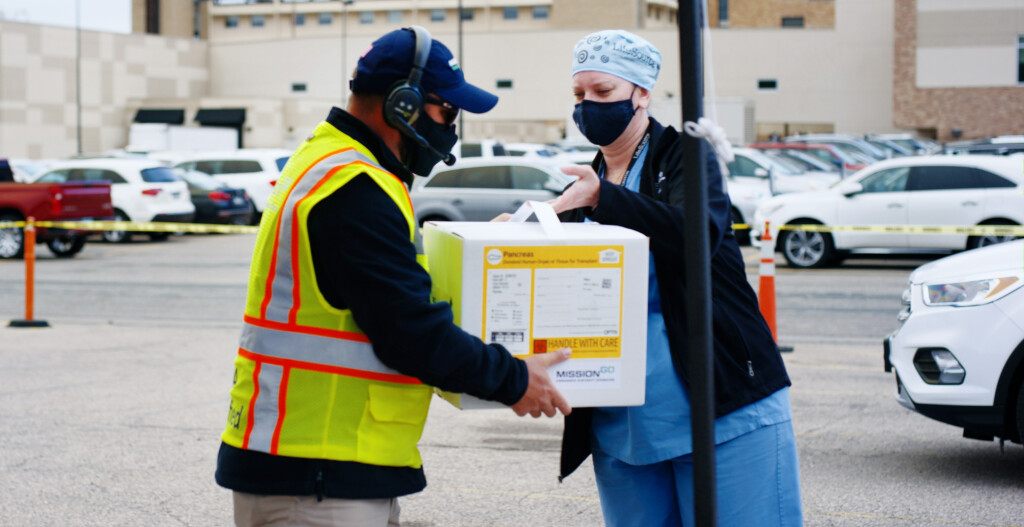
“The first thing that you have to consider when transporting organs is that they require a lot of ice. Ice is heavy,” explained Anthony Pucciarella, President of MissionGO. “Calculating the tradeoff between weight and payload has been the fundamental question since the beginning of aviation. It may be negligible for a full-sized aircraft, but for one that weighs less than 55 pounds, carrying a few pounds of ice is an issue. When you are transporting something as vital as an organ, the medical community is going to want to protect and preserve what is in transport, so they are going to want to pack more ice in case there are delays in the transportation to ensure that the organ will still be viable. But when you start pushing the limits of what an aircraft can do by adding more weight it adds another risk to the organ—the transportation method could have a catastrophic failure. So, we had to figure out with the medical community the balance between ensuring the safety of the transportation method and keeping the organ viable. It is something they never had to think about before, it was never a limitation: How do we protect the organ and ensure a safe flight? This isn’t unique to this kind of application, but it emphasizes what these tradeoffs and negotiations between cargo and distance mean.”
The continuous negotiation between weight and gravity is further complicated by regulations and distance.
“We are working on getting our 135 Certificate, but for what we’ve done so far it has been working within Part 107. This meant we had to plan routes that avoided flights over people and moving traffic while maintaining line of sight along the route. Because of this, we couldn’t fly a direct path. These are just some of the logistics and moving pieces that go into organ transport via unmanned aircraft, but things are moving in the right direction. I think streamlined regulatory approvals for type certification is going to be a major thing for the drone industry. It will have a huge impact on our ability to fly farther and complete more complex flights.”
When asked about whether or not distance and flight times should be a focus for drone companies, for Pucciarella it depends on the mission. He sees a lot of business cases for shorter distances like what he’s been doing with organ transportation, and drones can fly long distances in a short amount of time. But he emphasized that logistically, figuring out power, weather resistance, and the safety of the aircraft needs to be a primary focus regardless of how long a drone is in the air. Examples like MissionGO underscores why everyone needs to be focused on innovations in power technologies, whether you are flying for 25 minutes (the time it took to deliver a kidney during one of their trials) or for 13 hours.
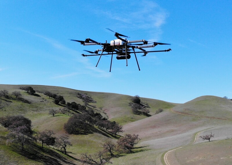
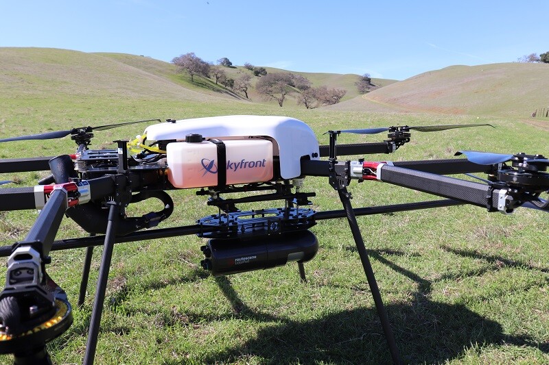
Merging Endurance with Essential Sensor Payloads Leads to Increased Productivity: A Collaboration Between Skyfront and Routescene
 “Lidar surveys tend to be out in the middle of nowhere. There’s a lot of rugged terrain that makes landing a drone challenging. Having to do that repeatedly becomes really cumbersome. Being able to do all of that in one flight is a game changer for the wider industry,” Troy Mestler, PhD., CEO and Founder of Skyfront.
By manufacturing most of their components, including the power source itself in house, Skyfront has been able to calibrate and optimize their system for things like weight, lift, and efficiency. Skyfront is a leading manufacturer of long endurance, gasoline-electric hybrid drones. Recently, their Perimeter 8 octocopter executed the longest flight time in the world (13 hours +) for unmanned multirotor systems. Although this is an impressive accomplishment in and of itself, Skyfront is working hard at demonstrating what this can mean for businesses. By partnering with sensor companies, like Routescene and Geometrics, they are providing valuable data solutions to the enterprise, especially for survey, inspection, and mapping solutions.
 “We are seeing customers wishing to cover longer distances or larger areas, but with current technology it takes time to land the drone, change the batteries, check the data, and then have to move to another site to collect the next set of data,” explained Jason Rogers, Marketing Manager at Routescene when asked why he was interested in longer flight times as a Lidar mapping system developer. “By being up in the air longer, you’re gaining huge amounts of productivity. For example, in initial tests with Skyfront, they were doing about two days’ work in one day. This is going to make a huge difference for businesses.”
“UAV Lidar surveys tend to be out in the middle of nowhere,” added Troy Mestler, PhD., CEO and Founder of Skyfront, when asked how better flight times were able to enhance productivity so dramatically. “There’s a lot of rugged terrain that makes landing a drone challenging. Having to do that repeatedly becomes really cumbersome. Being able to do all of that in one flight is a game changer for the wider industry.”
There are few modern-day tools out there that have been able to condense two days of work into one. To be able to quantify that with this partnership is incredibly impactful for businesses looking for ways to enhance their bottom line and improve workflows. A lot went into accomplishing this level of productivity—it wasn’t just a matter of putting just any sensor onto Skyfront’s platform.
“One of the things that attracted us to Routscene’s Lidar system is that they spent a lot of time optimizing it for weight,” explained Mestler. “That’s a huge thing for us. We have the ability to fly for a long time, but every ounce or gram you can shave off is worth its weight in gold. That is what they spent a lot of time doing. Its carbon fiber system is one of the lightest systems on the market.”
In addition to being lightweight, Routescene’s Lidar system is also able to collect data for up to 12 hours enabling that kind of long-range data collection. But none of these innovations were about a compromise on performance, it was about striking a balance between the two.
“When developing a system there is a tight correlation between performance, cost and the components you choose to use. For UAV mapping systems accuracy and weight are important factors.” Rogers pointed out. “For example, we use dual heading to improve accuracy, which is essential for mapping. This adds weight to the system but the increase in accuracy is worth it.”
The commitment to achieving longer flight times without sacrificing quality demonstrates what is required to meet the needs of enterprise users. The drone industry can’t just focus on one problem—the need for longer flight times—it needs to understand the requirements holistically and deliver on them. Skyfront and Routescene understand this and are demonstrating how to provide those solutions for enterprise users.
Realizing the Promise of Hydrogen Fuel Cells with Doosan Mobility Innovation
“The advantage of hydrogen fuel cells over battery drones is the flight time is about 4 times longer and the charging time is drastically shortened.” Soonsuk Roh, Business Development Manager at Doosan.
Hydrogen Fuel Cell power has been a topic of academic interest for a long time, and for good reason, because it is powered by a chemical reaction rather than combustion, there are no harmful byproducts. This makes it better for the environment, while also being an incredibly efficient power source. Despite this, we haven’t seen many commercially viable options out there (it can be difficult to source), which is what makes Doosan Mobility Innovation (DMI) unique in the drone space—they have proven multiple applications throughout countries in Asia and Europe.
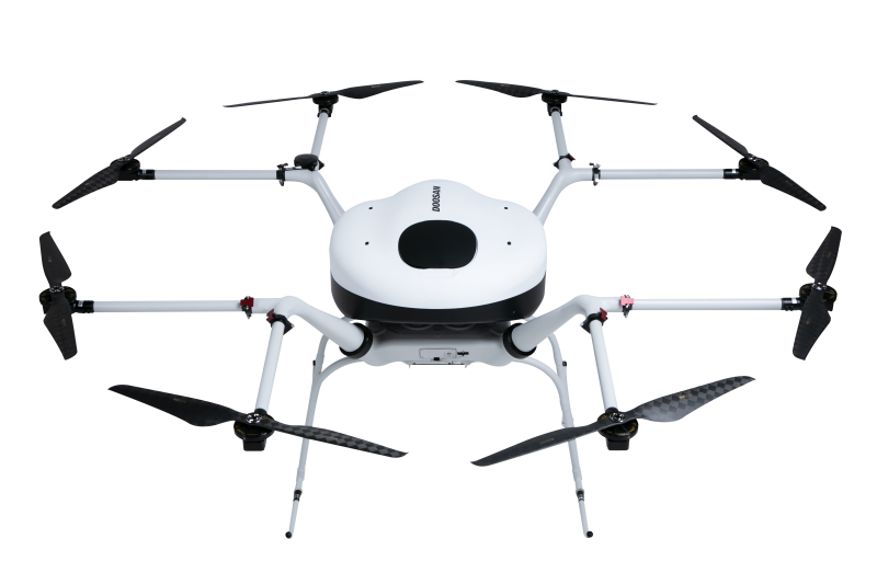
“The advantage of hydrogen fuel cells over battery drones is the flight time is about 4 times longer and the charging time is drastically shortened,” explained Soonsuk Roh, Business Development Manager at Doosan. “This saves time with mission execution. In addition, it is more eco-friendly than gas-powered drones.”
Soonsuk was able to specifically demonstrate what this means for multiple applications:
Solar Farm Inspections
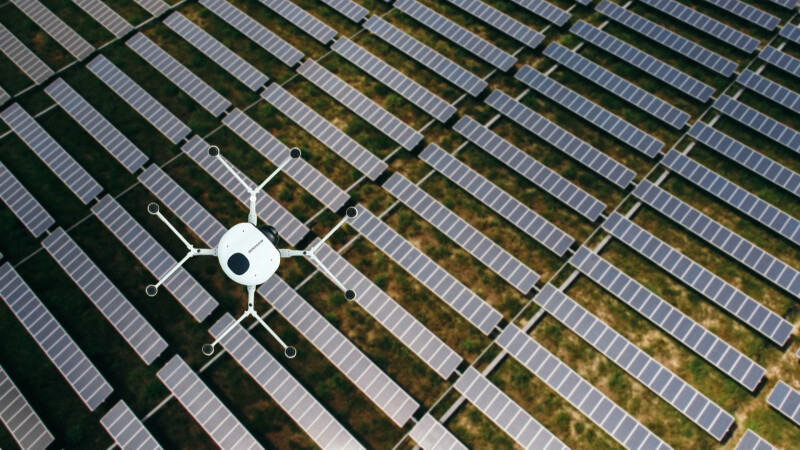
Solar farms are a globally growing industry as more countries look to combat climate change with green energy. To inspect these large farms, relatively heavy thermal cameras (~6.5 lbs) have to be used in order to get the proper resolution. Drones that have to land in less than 30 minutes make using drones a challenge for this industry. Doosan was able to partner with a solar farm spanning 100MW to provide the images they needed—opening up the potential for this growing industry.
Emergency Deliveries
In South Korea and for many island nations transportation is challenging. Boats and ships cannot always sail to these locations. Drones can be a powerful alternative delivery solution. The challenge is to ensure that these drones can make the long flights out and back. DMI was able to provide support because of their drones’ longer flight times. For one project in the Virgin Islands, DMI delivered 5 pounds of blood and bacteria samples between islands—a total of 42 miles. In another, they were able to deliver facemasks to small islands off the coast of Korea to help during the pandemic.
Long-Range Linear Inspections
Inspecting pipelines and powerlines are the quintessential business case for long-range drones. They are able to fly over difficult to reach areas like mountains and over rivers making these processes much easier for inspectors. For example, DMI has partnered with a gas company in Korea to inspect and monitor for illegal construction and any ongoing safety issues.
Search & Rescue and Natural Disasters
Every time a drone needs to land in a search and rescue mission means less time looking for a missing person. Having longer flight times means that DMI can cover more ground without needing to land.
They are also finding compelling use cases for using their drones in potentially dangerous environments, like looking for bushfires and monitoring coastline and national parks for landslides and other issues to help reduce property damage and save lives.
Offshore Wind Turbine Inspections
The use case for drones to help inspect offshore wind turbines has been compelling, but short-range drones often require a boat to take them out to the site. This has been deemed too complicated for many in this industry sector. With long-range drones, like DMI, this industry is reevaluating the potential of drones as they can take off from the shore without needing a boat.
Where Is It Being Used?
Currently, DMI hydrogen fuel cell powered drones are used in various cases not only in South Korea but also in other foreign countries. Due to the increase in interest in green energy in various countries, steady inquiries have been made, and as a result, diverse demonstration flights such as delivery and inspection are being prepared in cooperation with local governments in the Netherlands.
They are also slated to sign a contract for pipeline inspection with a government-run energy company.
These are just a few compelling examples of what hydrogen fuel cell powered drones are and can do for the enterprise. But at the moment these efforts are small scale, DMI hopes that these efforts will gain public interest and demand in the future, and to continue developing hydrogen fuel cell technology to meet those needs.
Inspecting Hazardous Industrial Sites and Challenging Terrain with SwissDrones
A lot of the cases we’ve discussed so far have been instances where long-range drones can take over for other modes of transportation or data collection. But when it comes to investigating potential incidents with radiation sending a person in is incredibly dangerous and can be life threatening. Unmanned aerial systems take the human out of the loop and get the data without putting people at risk. In a recent collaboration with the Swiss Federal Office for Civil Protection, SwissDrones, who recently has been the only company to successfully complete a challenge with the French utility company RTE for powerline inspections, was tapped to help detect radioactive particles for a possible leak.
 “Nuclear agencies have a particular challenge with manned inspections when responding to incidents that involve radiation,” explained Ulrich Amberg, CEO of SwissDrones, in a recent webinar with Commercial UAV News. “The agencies obviously don't want to expose humans unnecessarily to radiation sites if it can be avoided. Drone-based radiation inspections are a perfect solution when they can be deployed from a safe distance and carry the weight of the required sensors, including in remote areas. The project with the Swiss Federal Office of Civil Protection proved the feasibility of an unmanned aerial radiation inspection under real life conditions. We managed to locate and measure actual radiation sources placed on the ground. Currently our company is in contact with multiple governmental nuclear agencies across Europe, which are looking for ways to use long-range drones like the one from SwissDrones for such inspections, which I think is an obvious benefit and clear use case.”
One of the challenges of this particular use case is that the sensors used to detect radiation can easily reach a weight of 20 kilos or 45 pounds, depending on the type of sensor. In a realistic scenario, you would fly from a safe distance of up to 30 kilometers (20 miles) beyond visual line of sight (BVLOS) to the radiated site with these sensors onboard, collect the data, and return safely to base. The successful completion of this mission is an example of how new use cases for long-range drones can open up once technical challenges are solved.
Conclusion
It can be easy to get stuck in a certain mode of thinking—drones can already do so much with short flight times and within visual line of sight. But when we start solving the technical challenges with power and pushing the regulatory envelope, the opportunities grow exponentially. The examples above provide a sample of some of the many impressive use cases that can improve workflows, save lives, and expand the drone industry. But even the companies we spoke to for this article would say, these examples are just the tip of the iceberg, there are many more examples out there and more to be discovered.


Comments