

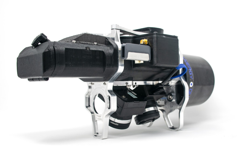
GeoCue has been exploring new and better ways to gather and process mapping data with drones ever since 2012. In that time they’ve done everything from highlight how low-cost drone platforms have become a game-changer in small site mapping to exploring how drone mapping changed the Lidar market. However, their most recent development of a compact, lightweight fused Lidar and photogrammetry sensor is arguably their most significant innovation in the space. With colorized Lidar point clouds, users can avoid having tied debates about whether photogrammetry or Lidar is the right choice for a given project. By focusing on making 3D imaging using a drone as easy to do as using RTK gear, the product can make a user productive with only two days of training.
Lewis Graham, Chief Technical Officer of GeoCue, has been at the forefront of these innovations that have changed expectations around how drones can be utilized by surveying & mapping professionals in various capacities across the country. That made him the perfect person to connect with to explore how some of these expectations might further evolve in 2020, what sort of purpose-built drone mapping solution he’s hoping to see take shape and much more.
Danielle Gagne: Colin Snow mentioned last year that the surveying / mapping / GIS services segment presents the most opportunities for service providers. Is that something you’ve seen and experienced? How do you see those opportunities changing or evolving in 2020?
 Lewis Graham: I think surveying and mapping represent a high-growth opportunity in drone applications. I cannot really comment on the growth compared to other applications such as quantitative inspection because my own company has not developed tools for this area.
In 2012, all the technology was piecemeal with a lot of “home grown” drones with strap on lightweight consumer cameras. The most popular autopilot was PixHawk with the open source software “Mission Planner” serving the dual roles of mission planning and flight management system. Mission Planner has literally hundreds of settings with which one can play. This is characteristic of any high-tech emergent system: lots of glue and hundreds of tweakable knobs. Early adopters made real products and did detailed analysis with these tools, but mainstreaming is not possible in the face of such complexity.
If we fast forward to 2019, we see very slick packages at a low cost such as the Phantom 4 RTK from DJI. This has almost enabled care-free use of drone technology for higher accuracy projects. I say “almost carefree” because the software is still lagging. Tools such as Pix4D and Metashape (formerly PhotoScan) dominate as the preferred way to build products from images, but these applications are still far more complex than need be. I also think workflow software is still a challenge for this industry and is limiting wide adoption by the general survey community. Things are easier than they were five years ago but not quite easy enough. I see this gradually changing over the next few years.
I do believe the current anti-Chinese technology position of the U.S. government is having a chilling effect on the industry. The banning of low-cost drones is bringing a resurgence of low volume, high cost specialty drones back to the market. On the face of it, this is a good thing. However, it is actually pushing us back to where we were several years ago. I feel our government is disconnected from how small drones are deployed and used, and hence is really bumbling about, simply causing chaos.
In summary, I think surveying and mapping for small areas are excellent opportunities for drone technology. However, there are still industry-wide obstacles, such as workflow software and the re-fragmentation of hardware (caused by current U.S. policy), that will dampen its growth for the next year or two.
You’ve previously talked about what it means to make a decision to utilize photogrammetry or Lidar for a given project, but earlier this year GeoCue announced the industry’s first drone Lidar/imagery fusion sensor. How has this product impacted the “photogrammetry vs. Lidar” debate, and how will it continue to impact the industry as a whole in 2020?
Quite often, the decision is financial. Small survey companies just do not want to invest in a Lidar system until they have proven they can make money with less expensive technology such as camera-only systems. Once they have been successful (meaning the output is consistently more effective than the technology they previously used) they will consider investing in higher end technology.
When mapping projects, photogrammetry is often preferred because feature recognition can be challenging in a Lidar-only point cloud. However, photogrammetry has inherent limitations with vegetation penetration and delineation of thin, linear objects such as wires and overhead equipment (e.g. conveyors, piping, etc.). Based on flying a lot of test projects over the past few months, it has become obvious to us that an RGB colorized Lidar point cloud gives the best of both worlds: very easy feature identification with the 3D fidelity of Lidar.
While the overall cost of entry for a fused Lidar/camera sensor is starting to come down, it is still significantly more expensive than a camera-only solution. Thus, these types of solutions will not displace camera-only systems where system cost is a primary consideration. However, I do believe that anyone moving up to Lidar would be much more satisfied with a fused system.
How have you seen drones change the expectations of survey and mapping professionals? It feels like we’re past the hype and unrealistic expectations of the technology, but will 2020 be the year drones are finally considered to be just another survey tool?
I think we are getting a lot closer to this point. Drones are another survey tool and they are not always the right answer for a particular job. For example, if I must collect topography over a populated area, this is going to be a problem. Maybe I can get a waiver, but should I? Drones are not 100% reliable so safety must always be the first and foremost consideration.
I don’t think we are quite past the turnoff that many surveyors experience when they first encounter the complexity of data processing. They are not satisfied with web-based solutions because most of these do not provide believable accuracy statistics. They are often frustrated with desktop experiences because their job is creating a topo map, not spending weeks learning new software packages. So, I think we still have a way to go before the drone is the first tool a surveyor reaches for.
That said, we have definitely moved past the early adopter phase of the technology. If you are familiar with the “Crossing the Chasm” model of technology adoption, I see no danger of disappearing into the chasm. The technology has moved beyond the “How cool it is to fly a drone!” to “we are saving weeks on topo projects using drone Lidar.” The technology has a compelling return on investment and, therefore, is here to stay.
What’s one thing you’re looking forward to seeing take shape with drone technology within the industry?
For the industry as a whole, I would really like to see a low-cost mapping grade laser scanner that is purpose-built for drone mapping enter the market in 2020. Only Riegl makes a survey grade drone scanner today (with Optech soon to release a high-end solution). All of the lower cost scanners are repurposed automotive sensors that were not designed around the parameters needed for drone mapping (e.g. multiple return, long range, high range accuracy, low noise, and so on). I do not see such a development on the horizon but perhaps some innovative startup will surprise us!

.jpg.small.400x400.jpg)


Comments