

Virtual Surveyor nv, the Belgium-based developer of the Virtual Surveyor software service that bridges the gap between drone datasets and CAD or GIS, released version 7.2 with new features, including slope steepness threshold, 2D view mode, and more.
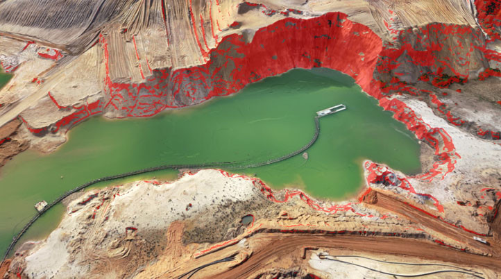
The Virtual Surveyor 7.2's new Slope Threshold lens tool automatically highlights terrain slopes that exceed dangerous steepness thresholds, significantly enhancing the safety of operations in sandpits, quarries and other dynamic environments with steep terrains. With this new tool, the Terrain Lenses, introduced in Virtual Surveyor 6.3 to provide a better understanding of the topography in a mapped area, can now stretch the color gradients, improving the 3D visualization of slopes, elevations, and contours.
“With the click of a button, operators of sandpits and quarries can see precisely where the escarpments surrounding their excavations have exceeded user-specified slope angles,” said Tom Op ‘t Eyndt, CEO of Virtual Surveyor nv in Belgium. “This enables the managers of sandpit dredging operations, for example, to remediate the situation before the slope collapses and hurts workers.”
Additionally, the 7.2 version introduces a new tool called MultiVertex editing to make previously developed features more accessible, such as Extract Level and Create Water which delineate a water feature with a single click where the water meets the edge of a basin, pond or quarry. The MultiVertex editing tool removes noise from the data and creates a perfectly flat elevation for the water surface in the generated surface model.
“Rather than click on dozens of points to delineate terrain bulges and jetties that extend into the water body and distort the perimeter, the MultiVertex tool lets the user click just once to delete the extraneous points,” Op ‘t Eyndt added.
Moreover, with a simple toggle, users can now switch between 3D and 2D maps to view multiple historical DSM vectors overlaid on the orthophoto since a 3D view can obscure those.
Designed to create surveys efficiently from drone data, Virtual Surveyor creates a real-world replica constructed from photogrammetry outputs, which allows surveyors to focus on surveying. During the past couple of years, the company has released a great number of software updates and features to continue its mission to provide surveyors with full control of their sites.
Virtual Surveyor offers a 14-day trial, and prices start at around $100 per month. The company will be at the Commercial UAV Expo in Las Vegas, USA, between 15-17 September 2020.


Comments