

Aiming to address customer needs and modernize workflows, Quantum-Systems' and Propeller Aero's recent partnership sees Propeller's PPK Drone solution provide PPK support to Quantum's Trinity F90+ drone to streamline data collection on large worksites.
Built for the construction, mining, and earthworks industries, Propeller's PPK Drone solution enables seamless surveying and 3D mapping of worksites by minimizing time in the field and making accuracy an easy, affordable option for businesses of all sizes. Propeller claims the platform features verifiable, survey-grade accuracy within 1/10 ft (3 cm), drag-and-drop processing with 98% surveys processed within 12 hours, and 24/7 support from wherever you are. To "harness the power of a fully-integrated solution" and offer a more straightforward user workflow, Propeller recommends using a DJI's Phantom 4 RTK, DJI's Matrice 300 RTK, WingtraOne, or the newly added Trinity F90+.
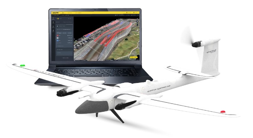
Debuted at INTERGEO 2019, the Trinity F90+ offers professional users many different features "at an excellent value for money resulting in a high return of invest." Featuring up to 90+ minutes of flight time, a wide range of high precision sensors (including dual RGB & NDVI payload and 42 MP HighRes RGB), up to 100 km (62 mi) flight and 7.5 km command and control range, and more, the Trinity F90+ is an eVTOL fixed-wing sUAS, uniting the convenient handling of a multi-rotor drone and the efficient aerodynamics of an airplane into one system. It also includes QBase 3D, Quantum's mission planning software, to conveniently plan aerial survey missions through automatic and efficient flight paths generated after defining observation areas and mission parameters.
"Today's contractors and surveyors are eager to adopt new technologies that modernize workflows and allow them to analyze more aspects of their worksite than ever before," Richie Hadfield, Head of Product at Propeller Aero, said. "The clients we work with are doing cutting-edge work in the construction, earthworks, and mining space and are already using drone technology to accelerate project timelines, reduce costly rework, and create safer environments for their employees. Our new partnership with Quantum-Systems gives our customers in Europe and around the world even more ways to achieve this increased efficiency and accuracy with the highly advanced F90+ drone."
By combining Quantum's drone with Propeller's PPK solution, Quantum states that contractors will be able to improve survey accuracy, condense their traditionally weeks-long data collection process into a few hours, and quickly share digital models among their broader worksite teams. Additionally, this package includes Propeller's integration with the Trimble ecosystem through Trimble Stratus, which helps companies use drones to map, measure, and share accurate information about their worksites and assets. The combined solution requires users to place Propeller AeroPoints - smart ground control points—around the worksite and then fly the Trinity F90+ drone above to collect survey data and upload it for Propeller's cloud-based platform to process it and return results within 24 hours.
"The drone industry has progressed a lot over the last couple of years, along with customer expectations," commented Florian Seibel, CEO at Quantum-Systems. "It is no longer reasonable to have customers figure out a complete solution for their needs. As a technology company, we listen to our customers and understand their needs and how best to address them. With the full Trimble Stratus solution completed with Trinity F90+, customers can proactively finish their projects from end to end."
Propeller's and Quantum's solution is now available for purchase through Propeller's channel partnership with Trimble and participating SITECH distributors.


Comments