


Our recent exploration of drones and the geospatial ecosystem highlighted the many ways that UAV technology is making an impact for surveying and GIS professionals. Reports about the surveying & terrain mapping segment having the most opportunity continue to be proven correct, but smaller surveying firms and project-based drone service providers are always on the hunt for tools that will help them best enable these opportunities. A new drone from senseFly was designed to be that exact type of solution.
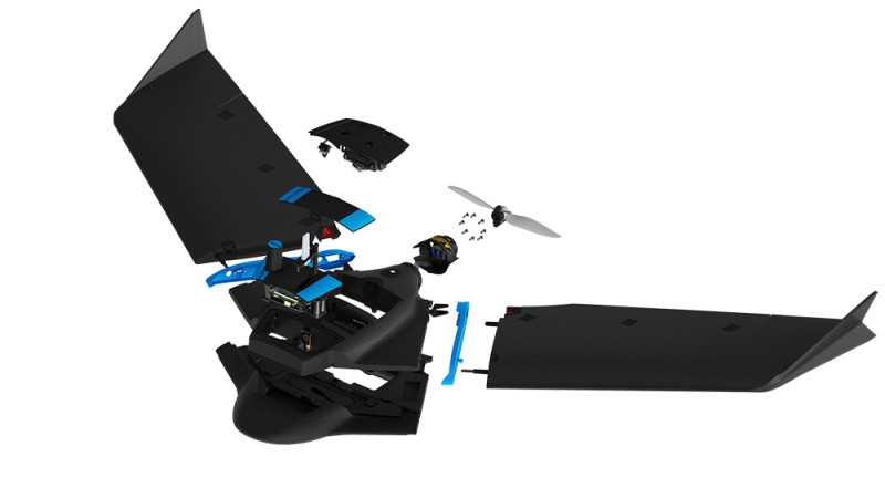 Announced earlier this month, the eBee Geo is part of the eBee X series of fixed-wing mapping drones. Developed in direct response to customer feedback, it offers the same premium-grade features as the eBee X but at a more affordable entry point. Just like the eBee X, which fits mapping needs across multiple industries, the eBee Geo allows surveyors to expand their project capabilities by helping them tackle jobs more safely, faster and with greater efficiency than using a quadcopter or via terrestrial mapping methods.
The eBee Geo is specifically positioned to be a fit for smaller surveying firms and project-based drone service providers that are working across a range of sectors, including land management, urban planning, industrial area mapping and humanitarian and disaster relief. What makes it such a good fit for these types of users though? Is that fit more about the cost of eBee Geo or the capabilities it possesses?
“Both its cost and mapping capabilities are what make the eBee Geo a great fit for smaller surveying firms and project-based drone service providers, regardless of experience,” said Michael O'Sullivan, Head of Marketing at senseFly. “For example, it is lightweight yet durable, and comes with a field backpack, which makes the drone equipment easier to carry into and out of the field. The eBee Geo is also RTK-ready, which means RTK processing is available for even greater geo-rectified and vertical data accuracy – ideally suited for surveying stockpiles and land change mapping, among other applications. As it has been developed from the same platform as our flagship eBee X fixed-wing mapping drone, users can expect the same data quality, product performance and reliability senseFly is known for, to help achieve a significant ROI.”
The eBee Geo is a standalone product that was created to be an entry point for any individual or organization looking to introduce drones and expand its mapping capabilities. Users do not need to be familiar with products like the eBee X, and access to senseFly’s eMotion flight planning software helps support new users by enabling operators to plan their missions, launch the drone and start collecting data in minutes.
Part of a family of products that now includes the eBee Ag, it’s fairly clear that senseFly is committed to creating products that users can apply in very specific ways. The eBee Geo showcases this specificity with its data quality and performance capabilities, which allows users to complete more complex jobs. However, where and how can survey professionals truly see these differences when it comes to completing a given project in a more efficient manner? What would it really mean for them to upgrade their mapping capabilities with the eBee Geo?
“The eBee Geo allows operators to scale the technology up or down depending on project requirements to elevate their mapping potential,” O'Sullivan told Commercial UAV News. “For example, it can be used to let surveyors take on and complete more complex jobs than using a quadcopter or terrestrial methods, such as mapping larger sites, faster and with more consistent data quality. Users can also be safe in the knowledge that the entire eBee X series has more than 10 years of research and development behind it, as well as the option for further training or support. All customers – wherever they are in the world – have access to both our global support team and local on-the-ground support from our large network of authorized distributors, as well as our wide range of educational materials, such as the senseFly Knowledge Base and video tutorials.”
To learn more about the eBee Geo, click here.


Comments