

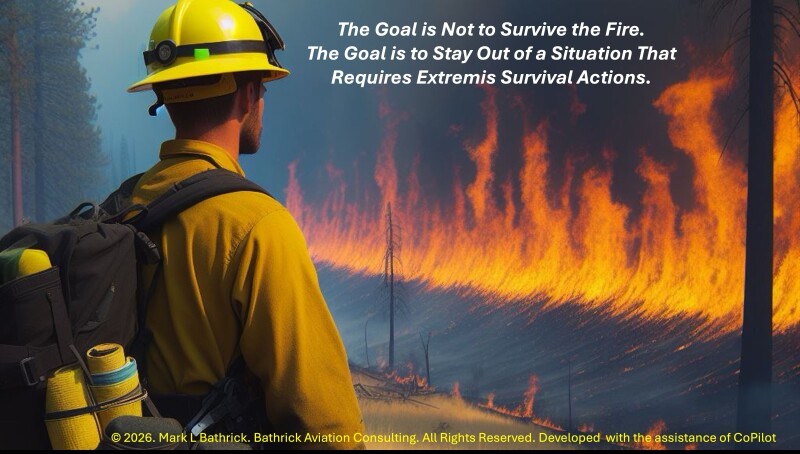
The Real Risk Wildland Firefighters Face
Wildland firefighters operate in one of the most unforgiving environments on earth. When wind, terrain, and fuel align, conditions can shift from manageable to lethal in seconds, leaving even the most experienced crews with no viable escape route. The Centers for Disease Control’s analysis of firefighter fatalities1 underscores this reality: Wildland firefighters face elevated risks of burnovers, heat illness, cardiac events, vehicle accidents, and aviation mishaps, all intensified by extreme physical exertion and rapidly changing conditions. These dangers are documented across decades of fatality investigations and reinforced by the tragic burnovers that continue to occur today, most recently on June 27, 2026, when Emily Barker (38), Nick Hutcherson (27), and Sydney Watson (27), three federal helitack firefighters assigned to the Knowles Fire along the Colorado-Utah border, lost their lives in a burnover.2 3
The Physics of Wildfire Behavior can Outrun Current System Reaction Time
Wildland fires differ fundamentally from structural fires. Wildland firefighters often work in mountainous, broken terrain where escape routes are long, steep, narrow, and easily compromised. Drainages, chimneys, bowls, and ridgelines can channel fire toward crews with little warning, creating the conditions in which most entrapments and burnovers occur.4 The National Wildfire Coordinating Group (NWCG) defines an entrapment as a situation in which personnel are unexpectedly caught in a fire-behavior-related, life-threatening position after escape routes or safety zones have been compromised.5 A burnover is a specific type of entrapment in which fire physically overruns personnel or equipment, often resulting in serious injury, fatalities, or apparatus damage.6
Although burnovers are rare relative to the approximately 69,500 wildfires suppressed annually in the United States between 1983 and 2025,7 their consequences are often catastrophic.8 NWCG Safety Gram and National Interagency Fire Center (NIFC) records show that from 1981 through 2017, 166 entrapment incidents involved 1,202 firefighters and resulted in 117 fatalities, averaging roughly four to five entrapments and three deaths per year.9 Many more firefighters suffered injuries.
The conditions that produce burnovers are well understood. Fire accelerates uphill in terrain channels, often doubling or tripling its rate of spread on slopes exceeding 30 percent.10 Embers lofted ahead of the main fire can ignite spot fires hundreds of yards or even miles ahead of the fire front.11 Frontal passages and convective weather can shift winds 90 to 180 degrees with little warning at ground level.12 Together, these factors create a fast-moving, three-dimensional fire environment that crews operating within it cannot fully observe in real time.
We Must Focus on Remaining “Left of Extremis”
What is particularly sobering is that entrapment incidents have not significantly declined even as overall firefighter fatalities have trended downward. We have gotten better at surviving entrapments through improved fire shelters,13 deployment training,14 and post-entrapment rescue, but not at preventing them. The fire shelter is a last resort, not a management tool. If it becomes the plan, we are managing to the last line of defense and calling it progress.
As a Navy fighter pilot, I understood my ejection seat with absolute clarity. It was indispensable, engineered, tested, maintained, and trusted. But no aviator ever briefed a mission hoping to use it. It existed only for the moment when planning, training, situational awareness, aircraft performance, and tactical decision-making had failed. A fire shelter occupies that same moral and operational space in wildland fire: essential, lifesaving, and proof that the system has already reached extremis.
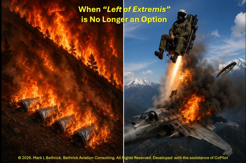
That is what I mean by moving firefighter protection “left of extremis.” In aviation, we invest relentlessly in everything that keeps aircrew from reaching the ejection decision: better sensors, better weather intelligence, better training, better procedures, better cockpit displays, better decision support. Wildland fire deserves the same philosophy. The objective is not merely to improve the last-resort survival tool, but to keep crews from ever needing it.
After sixteen years as Director of DOI’s Office of Aviation Services, after reviewing entrapment investigations, sitting with incident commanders, and reading the names on safety grams and fatal burnover reports, I will say this without equivocation: “The technology to close the burnover information gap exists today. It is deployed. It has been field-validated.” What we owe the next crew and what we owe Emily, Nick, and Sydney, the latest wildland firefighters to perish in a burnover, is the institutional will to scale it without further delay.
Beyond the Physics of Wildfire – What Other Factors Contribute to Burnovers
LCES — Lookouts, Communications, Escape Routes, and Safety Zones — was developed to prevent entrapments and burnovers. Yet investigations over decades have repeatedly identified breakdowns in that sequence as contributing or primary causes: lookouts not posted or unable to see the relevant fire area; communications degraded by radio range, smoke, terrain masking, or delayed information flow; and escape routes or safety zones compromised before crews had enough warning to act.
These failures recur not because firefighters forget LCES, the Standard Fire Orders, or Watch Out Situations, but because ground-level perception and communications often cannot keep pace with fire behavior in complex terrain. Compliance requires timely information that is frequently unavailable from the ground, making the solution technological as well as cultural.
Culture compounds the architecture gap. The “Always Syndrome” is the well-intended but dangerous belief that firefighters must always push harder, stay longer, hold the line, and accept risks that deteriorating conditions no longer justify. Heroic over-commitment, normalized risk, mission pressure, and emotional attachment to the objective can delay disengagement until escape routes and safety zones are no longer viable.15
U.S. Wildland Fire Service (USWFS) Chief Brian Fennessy’s Mission-Driven Culture addresses this human and organizational side through Leader’s Intent, professional turndowns, non-punitive reporting, and decentralized decision-making.16 Those reforms matter and must continue. But culture alone cannot solve a real-time information deficit: firefighters cannot maintain LCES, reassess trigger points, recognize a collapsing escape route, or withdraw in time if decisive information never reaches them.
The through-line is clear: burnovers rarely result from one bad decision or missed rule. They occur when fast-changing fire behavior, complex terrain, imperfect communications, human limits, cultural pressure, and delayed authority outpace the incident information system. Too often, firefighters and supervisors lack the timely, accurate, decision-oriented information needed to see the threat, understand its speed and direction, communicate it clearly, and move before the escape window closes.
That is why drones are central, not peripheral. UAS with thermal sensors, real-time mapping, communications relay, and emerging AI-enabled tools directly address the information gap that has closed around crews too late. By detecting heat, mapping perimeters, cueing resources, reducing exposure, and supporting life-saving decisions in fast-moving environments, drones offer one of the clearest paths to keeping more firefighters left of extremis.
How DOI’s “Drones for Good” Program Proved Drones Can Save Wildland Firefighter Lives
From 2006 to 2021, I had the privilege of building and leading one of the world’s largest civilian government UAS programs. By the time I retired as Director of DOI’s Office of Aviation Services, DOI had fielded more than 850 government-owned and contracted drones and flown more than 30,000 missions across all 50 states and several U.S. territories, supporting more than 25 mission applications.17
But scale alone would not earn trust. The DOI “Drones for Good” 6-S framework–Sensing, Safety, Savings, Service, Sustainability, and STEM–explained why drones mattered in measurable public terms. In wildland fire, the most important outcome was safety: putting timely, accurate, decision-oriented information over firefighters when smoke, darkness, terrain, and low visibility grounded crewed aircraft. DOI’s early UAS work proved that drones could become airborne extensions of LCES — lookouts, mappers, scouts, communication relays, and tactical decision aids available when traditional aviation was grounded in degraded visual environments (DVE).18
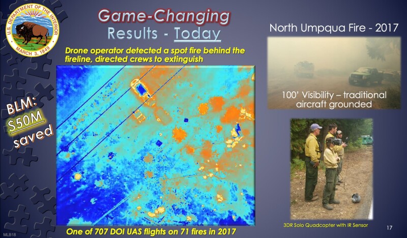
The 2017 North Umpqua Complex Fire in Oregon became an early demonstration of how drones could save firefighter lives.19 Near Toketee Dam, more than $50 million in infrastructure and property was at risk, including the power plant, homes, and a U.S. Forest Service ranger station. Smoke reduced visibility to roughly 100 feet and grounded crewed aircraft. During a burnout operation, DOI remote pilots launched an infrared-equipped quadcopter for live situational awareness. It detected a spot fire across the control line behind firefighters’ working position. Because the drone saw it in time, the location was relayed, ground resources were directed to it, and firefighters contained it before it escaped.20
A year later, on the 2018 Taylor Creek Fire in southwest Oregon, a contracted ScanEagle UAS demonstrated the same value at night.21 While monitoring an overnight burnout from roughly 8,500 feet, its infrared sensor detected a tiny spot fire about 100 feet outside the fireline in unburned fuel. Because the sensor could see both the heat source and firefighters moving through thick timber and brush, the operator guided the crew directly to the ignition: “Engine 66, stop there, spot fire is out your passenger door, 100 feet.” The crew extinguished it before it became a wind-driven threat behind the line.22

These events matter because spot fires are a classic pathway to entrapment. They ignite outside the expected perimeter, often behind crews, and can cut off escape before firefighters know they exist. In North Umpqua and Taylor Creek, the drone changed the timeline: it detected the hazard first, turned detection into actionable direction, and kept firefighters left of extremis before the spot fire became a burnover problem.23
DOI’s work with the University of Nebraska–Lincoln created another safety advance: the world’s first operational small-drone aerial ignition capability. In 2016, a DOI/National Park Service/University of Nebraska–Lincoln team used a UAS with a plastic sphere dispenser to conduct interior ignitions at Homestead National Historical Park.24 It provided the effect of helicopter-borne aerial ignition without placing pilots and crews into low-level, low-speed flight over prescribed or active fire, a mission type that had already cost two helicopters and five lives between 2005 and 201625 26 and another in 2019.27
Drone-based aerial ignition has changed both prescribed fire and active wildfire operations.28 It can reduce or eliminate helicopter ignition on many prescribed burns and enable safer burnout operations on active fires, including at night when humidity, winds, and fire behavior may be more favorable and thermal sensors make ignition patterns easier to observe. Properly managed, these operations reduce fuels ahead of the main fire, strengthen control lines, and reduce the chance that firefighters later confront uncontrolled, high-intensity fire at close range.29
Drones also serve as mapping and communications infrastructure.30 They collect infrared imagery, map perimeters, identify heat concentrations and spot fires, and transmit imagery and video to incident leaders and crews. That shortens the time between detection and decision, reduces uncertainty about where the fire is, and helps supervisors adjust tactics before crews are committed too deeply into changing conditions.31
Drones need not be small to deliver life-saving value. In 2014 and 2015, DOI demonstrated the optionally piloted K-MAX32 helicopter as a remotely piloted wildland fire aircraft.33 In joint work with Lockheed Martin and Kaman, it performed cargo delivery, water drops, progressive line-building, and logistics missions, including simulated emergency extraction, without requiring a pilot onboard.34 The point was exposure reduction: remotely piloted heavy-lift aircraft can perform dangerous, repetitive, low-level missions, including water drops, resupply, backhaul, and potentially emergency extraction support, while reducing risk to aircrews and firefighters on the ground.35
Taken together, these missions show what drones have made possible for more than a decade: overhead eyes when smoke or darkness grounds crewed aircraft; infrared detection of unseen spot fires; direct guidance through heavy fuels; safer ignition; near-real-time perimeter intelligence; video to decision-makers; and remotely piloted aircraft capable of suppression, logistics, and emergency support. DOI’s operational experience demonstrated that UAS are not experimental curiosities.
Drones are proven life-safety tools in wildland fire. By reasonable estimates from the program’s operational history, drone-enabled detection, guidance, mapping, ignition, and exposure reduction have already saved 15 to 25 firefighter lives. The urgent question is not whether drones can save firefighters; they already have. The next section shows that the same life-saving logic extends beyond the fireline: the 2018 Kilauea volcano drone rescue demonstrated how aerial sensing, real-time communication, and guided movement to safety can keep people ahead of an otherwise unsurvivable threat — a proof of concept for helping firefighters avoid entrapments and burnovers before conditions reach extremis.
The 2018 Kilauea Volcano Drone Rescue: A Proof of Concept for Burnover Avoidance
In 2018, as Kilauea opened new fissures and sent fast-moving lava toward residential areas, DOI OAS showed what uncrewed aircraft can do when lives hang in the balance. Operating inside the eruption zone, a government-owned drone used thermal sensors and live video to detect a new lava flow before ground observers could see it. Emergency managers issued an immediate evacuation warning, giving residents time to escape an otherwise unsurvivable event.36
The drone then became a lifeline. Operators located a resident trapped behind advancing lava and, using the aircraft’s camera, lights, and communications, guided the person through lava-blocked roads toward first responders.37 They also helped rescuers navigate around newly formed barriers,38 making the mission one of the clearest early examples of a drone directly enabling a life-saving natural-disaster response.39
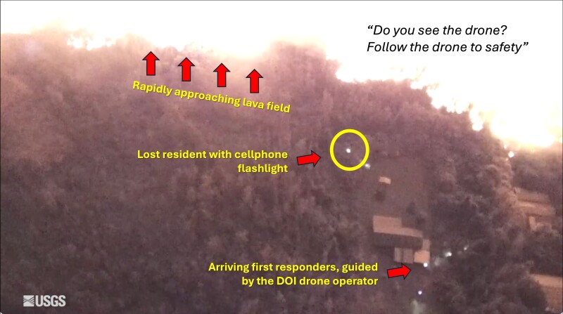
For wildland fire, the lesson is direct. Lava flows and wind-driven fires share lethal characteristics: rapid acceleration, unpredictable movement, degraded visibility, blocked escape routes, and the collapse of traditional situational awareness. In both environments, the difference between life and death often comes down to seconds, visibility, and the ability to act before conditions become untenable.
The proof-of-concept elements are the same ones needed for burnover avoidance: rapid detection of a fast-moving hazard, real-time alerting across the incident, and guided movement through a changing hazard zone. The Kilauea drone saw the threat first, enabled an immediate warning, and helped move a trapped person to safety.40 In wildland fire, drones can do the same when spot fires, wind shifts, or collapsing escape routes threaten crews. Burnover investigations repeatedly show that crews often recognize danger only when escape is no longer possible. Drones can change that timeline.
Kilauea therefore makes the case for UAS in life-threatening, degraded-visibility environments.41 The remaining question is why the same capability is not persistent on every major wildfire. If drones can detect the hazard first, communicate it in real time, and guide people out of danger, the barrier is no longer proof of value. It is the ability to integrate drones, crewed aircraft, and optionally piloted aircraft safely in crowded fire airspace. That is the airspace problem, and it is why NASA’s Portable Airspace Management System (PAMS) matters.
The Airspace Problem — and Why NASA PAMS Changes Everything
Wildland fire airspace is among aviation’s most complex and lethal operating environments.42 A large fire may host air tankers, scoopers, helicopters, lead planes, air tactical group supervisor (ATGS) aircraft, multi-mission platforms, and UAS at multiple altitudes — all in smoke-reduced visibility, over terrain that masks radar and radio signals.43 A midair collision would not merely be an aviation incident; it could be a mass-casualty event.44 45 46 I experienced the risk firsthand on the 2013 Beaver Creek Fire when, flying with an experienced lead plane pilot, we heard an air tanker radio, “don’t climb,” then looked up to see the belly of a C-130 only a few hundred feet above us.
Today, that coordination largely depends on the ATGS, who flies above the fire and visually orchestrates traffic across multiple radios.47 It works, but only when crewed aircraft can fly safely, visibility is adequate, and aircraft loading remains manageable.48 At night, in heavy smoke, or in marginal VFR conditions, sustained crewed operations are often curtailed — precisely when aerial suppression and situational awareness may be most valuable.49
NASA’s Portable Airspace Management System (PAMS) is designed to close that gap.50 It is a suitcase-sized, ground-deployable system built on NASA air traffic management and UAS Traffic Management (UTM) research.51 PAMS provides shared, real-time awareness of aircraft locations and flight intents,52 supports digital coordination among UAS operators, and issues automated alerts when crewed or uncrewed aircraft deviate from approved zones.
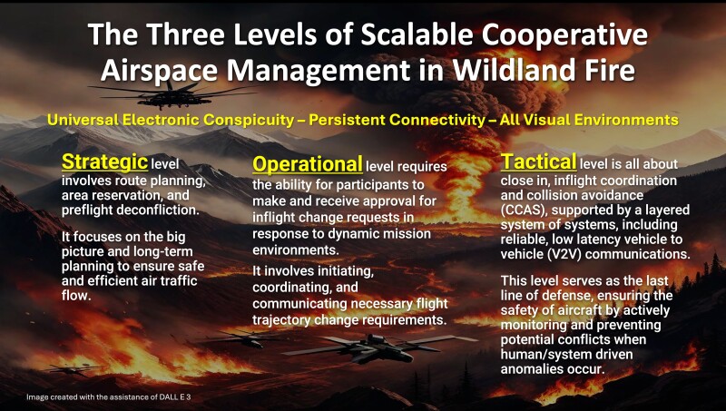
The strategic implication is enormous. PAMS replaces visibility-dependent coordination with digital coordination that can work in darkness, smoke, and terrain-limited environments. It can give pilots, incident commanders, ATGS, and UAS operators the confidence to integrate crewed, uncrewed, and optionally piloted aircraft at the scale required to provide firefighters more opportunities to stay “left of extremis.”
PAMS is therefore enabling infrastructure for a different operational model: one in which loss of visibility does not mean loss of aerial situational awareness, and a crew building handline in near-zero visibility can receive the kind of fire behavior information that has historically been available only in good daylight flying conditions.53
What Interagency Leadership Must Do Now
Let me be clear about where we stand: the proof phase is over. We have already demonstrated and fielded the core capabilities needed to give firefighters and supervisors more opportunities to stay left of extremis:
- Persistent UAS overwatch that detects heat, maps fire perimeters, identifies spot fires, and transmits imagery and video to incident leaders and ground crews when smoke, darkness, or terrain limits crewed aviation.
- Real-time life-safety support demonstrated at North Umpqua, Taylor Creek, and Kilauea, where drones detected unseen hazards, delivered actionable information, and helped keep people ahead of rapidly changing threats.
- Drone-based aerial ignition that reduces exposure to hazardous low-level helicopter ignition missions while enabling safer prescribed fire and night burnout operations.
- Optionally piloted aircraft capable of remotely piloted water delivery, logistics support, and simulated emergency extraction, reducing the need to place pilots and crews in the most hazardous flight environments.
- Digital airspace management through PAMS, showing that drones, crewed aircraft, and optionally piloted aircraft can be coordinated safely in the complex, low-visibility airspace where firefighter information needs are greatest.
What we lack is not capability. We lack scale, consistency, doctrine, and the policy framework to make these proven capabilities mainstream across wildland fire rather than exceptional resources that appear only when the right aircraft, operator, authorization, or funding happens to be available.
A central reason is structural: the federal wildland fire enterprise still lacks an accountable technology requirements authority with the power to define operational needs, validate field-proven capabilities, fund transition, set adoption timelines, and hold agencies responsible. As Dan Reese and I argued in The U.S. Wildland Fire Service at an Inflection Point, the problem is not a lack of ingenuity; it is the absence of a system that moves technology from idea to sustained field capability.54 That gap has left tools that could keep firefighters left of extremis unfielded, fragmented, or marginal long after they proved their value.
The unfulfilled 2019 mandate in Section 1114 of the John D. Dingell, Jr. Conservation, Management, and Recreation Act is the clearest example. Congress directed Interior and Agriculture to accelerate UAS and wildfire technology integration, including technologies to remotely locate fire resources and personnel.55 That capability is foundational: drone-based heat detection, perimeter intelligence, video, and warning signals become actionable only when commanders can connect them to the known location of crews, engines, dozers, aircraft, and escape routes. You cannot guide people away from an emerging burnover threat if you do not know where they are.
President Trump’s Executive Order 14308, Empowering Commonsense Wildfire Prevention and Response, and DOI’s establishment of the U.S. Wildland Fire Service create a rare opportunity to fix this governance failure.56 The order recognizes that firefighters rely on outdated technology, that bureaucracy impedes rapid response, and that DOI and USDA must streamline governance and develop a technology roadmap covering artificial intelligence, data sharing, modeling, mapping, and ignition-identification tools. Interior’s new Wildland Fire Service likewise promises to reduce duplication, modernize response, invest in technology, and build a unified system faster than the fragmented structures it replaces.57
But promise is not implementation. The same bureaucracy that kept field-proven UAS, blue-force tracking, optionally piloted aircraft, AI-enabled decision support, and digital airspace management from scaling can still slow or dilute the reforms now being announced. Chief Brian Fennessy’s Mission-Driven Culture is directly relevant: leader’s intent, trust, decentralized authority, non-punitive reporting, and action in uncertainty are institutional modernization principles as much as fireline leadership principles.58 If the new U.S. Wildland Fire Service is to honor that doctrine, it must empower a requirements authority that can define what capability is needed, by when, at what scale, and with what accountability.
Mainstreaming these tools requires five commitments. First, interagency leaders must provide sustained funding to scale UAS, blue-force tracking, AI decision support, PAMS, and optionally piloted aircraft. Second, they must pre-position UAS and airspace-management packages in high-risk areas before peak fire weather arrives. Third, doctrine must treat persistent aerial situational awareness, thermal mapping, communications relay, and digital deconfliction as standard operational infrastructure. Fourth, the workforce pipeline must produce enough UAS operators, airspace managers, data analysts, and incident leaders to turn these tools into actionable decisions. Fifth, interagency and FAA policy must make mixed crewed, uncrewed, and optionally piloted operations routine, authorized, and repeatable.
Scaling also requires leadership that treats protective innovation as an obligation, not a threat to firefighter identity. Fennessy’s doctrine gives crews the confidence and permission to disengage before uncertainty becomes entrapment; drones, blue-force tracking, AI, and PAMS provide the timely, accurate, decision-oriented information that makes that doctrine operational.
Therefore, modernization must begin with accountable requirements ownership. The U.S. Wildland Fire Service should designate or create a federal wildland fire technology requirements authority to translate firefighter life-safety needs into funded, time-bound capabilities: resource and personnel location, persistent UAS overwatch, drone-to-crew warning pathways, PAMS-enabled airspace integration, AI-supported fire behavior tools, and doctrine for routine use. Without it, the system will keep celebrating demonstrations while failing to deliver routine availability where firefighters need it most.
That is the leadership task now: move from proof to policy, demonstration to doctrine, statutory mandate to operational delivery, and exceptional deployment to routine availability. The question is no longer whether these tools work. The question is whether interagency leadership will create the accountable requirements’ structure needed to make them standard before we are again forced to add names to the Wildland Firefighters Monument.59

Keeping Firefighters “Left of Extremis” with Modern, Proven Tools: Drones, Blue-Force Tracking, AI, and Portable Airspace Management is a fundamental duty of leadership








Comments