

A UNIVERSAL NEED
Whether you are a startup seeking capital, an established business, an aspiring government program, or a long serving one, being able to craft a meaningful and clearly articulated return on investment (ROI) is critical to your success. Established industries usually have well-known ROIs, derived from their clarity and experience with the relevant inputs, outputs, and risks of their product and/or service. However, new disruptive business applications, like drones often require equally new thinking about their ROIs.
When I first became involved in drones during my Navy career in the 1980s, we discussed the ROI of drones as it related to the mission of naval aviation. We believed drones could enable safer operations in four distinct areas: dull, dirty, dangerous, and difficult/denied access use cases. While the 4-Ds accurately described the challenges drones could overcome, they primarily focused on the work environment challenges and the potential negative ROI associated with traditional methods. While appropriate for the military context, they failed to define specific positive outcomes and the constructive ROI that this disruptive technology promised in the commercial and public safety sectors.
When we initiated the U.S. Department of the Interior’s (DOI) “Drones for Good” program in 2006, we recognized the need for a more positive ROI framework, particularly considering the conventional perception of drones as weapons of war and tools of the intelligence community. In developing this strategy, we established several guiding principles for our prospective ROI framework:
1. The framework should be broadly applicable to any drone manufacturer, service provider, emerging, or established drone program, regardless of the industry or use case.
2. It must clearly and effectively demonstrate the disruptive potential of drones in enhancing traditional methods of accomplishing the same task or mission through measurable outcomes.
3. The framework should align with the capabilities of drones and the priorities of users and their customers.
4. It should be easily understandable and relatable across all stakeholder groups, including the public. We understood that drones, unlike other new technologies, often evoke strong opinions, and building and sustaining public trust in their use for “drones for good” was crucial.
5. The framework should be simple and intuitive, making it easy to remember and apply.
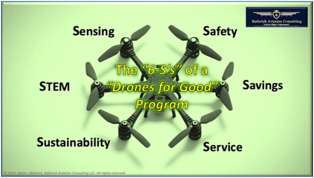
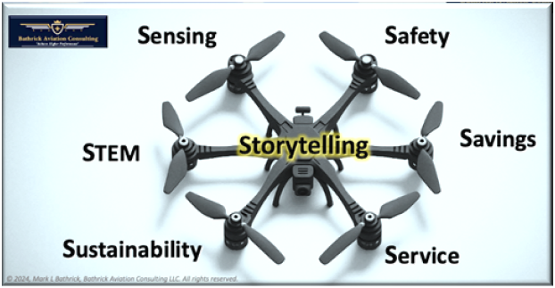
As a result, we developed the 6-Ss framework for the DOI “Drones for Good” Program: Sensing, Safety, Savings, Service, Sustainability, and STEM.[i]
SENSING
One of the most common uses for the drones is to collect imagery or other sensory data.[ii] [iii] For that reason, we start here discussing the factors that have driven increased ROIs in this “S.”
Rapid Growth in Access to the 3rd Dimension: Before the drone fueled democratization of the 3rd dimension, being able to routinely operate in that space required significant funding, training, planning, and specific medical qualifications to become a licensed pilot. These factors severely limited the number of individuals who could venture here. However, current FAA data reinforces how drones have profoundly increased access to the national airspace system (NAS). Since the FAA commercial rule (Part 107) was enacted in August 2016, the number of remote pilots in the U.S. has grown to 427,498 in 2024. In less than nine years, the number of remote pilots has grown to the point that they make up more than 50% of all estimated active airmen certificates held (which have been issued for nearly 100-years).[iv]
Increasing Observable Volume: Drones have enabled a significant increase in sensing capabilities, far surpassing the growth in the number of licensed operators. Unlike ground-based sensors, drone-borne sensors experience a non-linear increase in their observable area. This is because the height and radius of the drone’s observation area both contribute to this expansion. For instance, the observable volume at 200 feet is 2.83 times that at 100 feet, and at 1,000 feet, it is approximately 32 times that at 100 feet.[v]
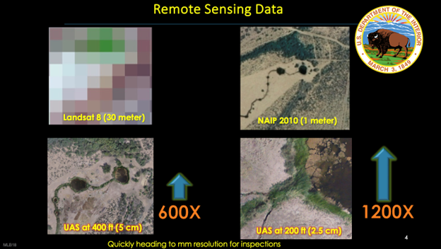
Resolution: The rapid and continuous advancements in reducing the size, weight, power, and cost (SWaP-C) of drones, along with the increasing resolution of optical, infrared (IR), multispectral, and similar sensors, have led to orders of magnitude improvements in resolution compared to traditional sensors carried aboard satellites and manned aircraft. Moreover, the low altitude at which drones operate further enhances their capabilities.
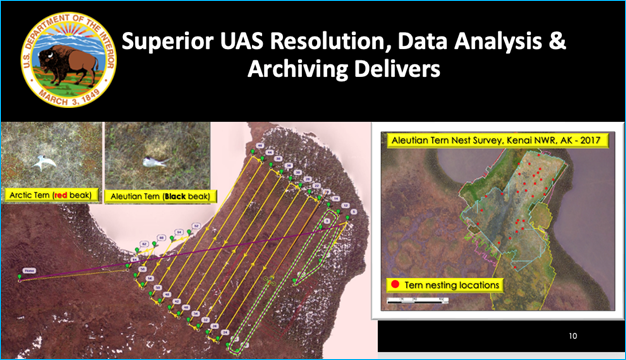
This high-resolution imaging can capture detailed color differentiation, which is crucial as demonstrated in a 2017 DOI survey of the vulnerable Aleutian Tern’s nesting locations in Alaska. However, these surveys faced challenges due to the shared nesting areas and similar appearance of the Aleutian Tern and the Arctic Tern, except for the Aleutian Tern’s distinctive red beak. Before the advent of drones, these surveys were conducted by boat, land, or traditional aircraft, each of which posed difficulties in minimizing disturbance to the birds, which often abandoned their nests when disturbed. By utilizing a battery-powered fixed-wing drone, DOI was able to conduct these surveys quietly, enabling them to overfly the nesting sites and accurately differentiate the Tern species based on the color of their beaks.[vi]
Persistence: While most small drones have limited flight endurance, and current regulations often require waivers for beyond visual line of sight (BVLOS) flights, they offer a greater level of persistence compared to many traditional methods. As drone propulsion technologies continue to advance and regulations permit extended flight distances, the sensory persistence provided by drones will likely increase.
Repeatability: Drones have revolutionized operations by introducing an unprecedented level of repeatability. Unlike traditional methods, which are often hindered by human error, variable conditions, and the inherent limitations of manual surveying, drones can be precisely programmed to follow the same flight path over a target area repeatedly. This high degree of repeatability ensures that data is collected under nearly identical conditions during each mission, which is crucial for accurate trend analysis and identifying significant changes.[vii] [viii]
Variety: Since 2006, small drones have seen a remarkable expansion in their capabilities. This transformation is primarily attributed to the proliferation of sensor payload options, which have elevated them from simple aerial platforms to sophisticated multi-sensor data collection systems. This evolution has not only increased the number of available sensor payload options but has also significantly expanded the scope of actionable data that can be gathered. This data can be utilized in various applications, including environmental monitoring, precision agriculture, infrastructure inspection, and emergency response.
Data Analytics & Better Decision Making: The diverse and extensive amount of high-resolution data collected by drone sensors serves as a rich source of “raw material” from which increasingly sophisticated computing can be applied.
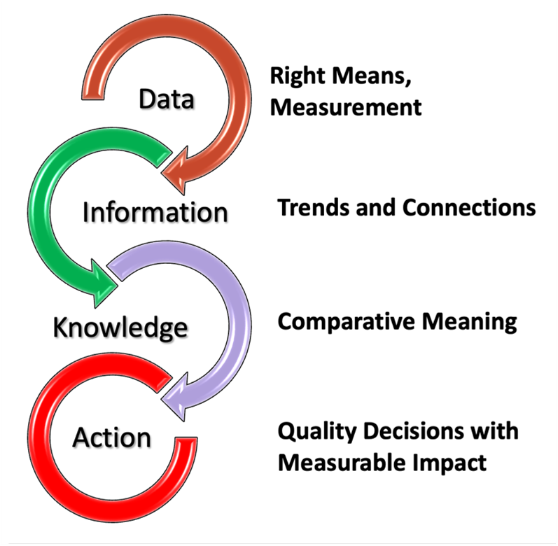
This enables the identification of informative trends and connections, gaining meaningful knowledge about how results compare to expectations, and making better-informed decisions through recommended actions that lead to measurable results. In the early days, this often involved physically transferring the data from the drone to a laptop, where it underwent lengthy processing to produce the final product. While this represented a significant improvement over many previous traditional methods, advancements in AI now hold the promise that much of the data analytics and product development will occur onboard the drone in the future. This expedites the Data-to-Information-to-Knowledge-to-Action process, further enhancing the ROI.[ix]
Factual Record: Drone-borne sensor payloads provide rich data and supporting analytics that offer valuable policy and archival ROIs. For instance, the U.S. Department of Agriculture (USDA) has increasingly relied on drones for precision agriculture initiatives.[x] Drone data, encompassing aspects such as crop health, irrigation requirements, and damage assessments following extreme weather events, supports policy decisions related to subsidies, disaster relief, and long-term environmental management. This data aids in refining government programs aimed at supporting the agricultural sector. At the state level, several transportation agencies have piloted drone programs to inspect bridges and roadway infrastructure. The precise data gathered by these drones informs maintenance schedules and safety protocols. Consequently, the results of these inspections have influenced policy decisions regarding infrastructure investments and funding priorities.
SAFETY
Substituting drones in traditionally hazardous applications delivers a compelling return on investment by significantly enhancing safety while reducing both direct and indirect costs associated with human risk. Drones improve safety by reducing the risk in air and ground operations. Their embedded automation significantly reduces the probability of human factors errors, which account for approximately 85% of all aviation mishaps. Moreover, the absence of a pilot onboard further minimizes the potential for a catastrophic effect of any mishap. The data they collect also improves the response to public safety emergencies, mitigating risk to first responders.
Air Exposure: Drones have been widely used to eliminate the risk from putting pilots and aircrew in the air. In 2016, following repeated helicopter crashes and fatalities in the hazardous aerial ignition mission, DOI partnered with industry to develop the first drone-based aerial ignition capability, eliminating this risk while also able to expand operations to night.[xi] [xii] Drones have also been successfully employed in airborne wildlife and habitat surveys, eliminating a risk which resulted in 66% of all field biologist fatalities from 1937 to 2000.[xiii] Agricultural spraying is another high risk area where drones have increasingly been deployed to reduce human risk in the air (there were 50 agricultural manned aircraft accidents and nine fatalities in 2022).[xiv]
Ground Exposure: By replacing traditional hazardous ground operations, drones can achieve significant safety improvements. The growing use of drones in washing windows and cleaning buildings is a great example of this opportunity.[xv] According to the OSHA Safety Training Institute, falls are the leading cause of death in the construction and window washing industry, accounting for nearly 34% of all fatalities.[xvi] Enhanced safety from these applications extends beyond the participants to the public. In the case of drone window washing, hazards to the public from scaffolding, dropped equipment, etc. are eliminated. Because drones typically complete most tasks in 1/10th the time of traditional methods, the public risk exposure (and inconvenience) time is also reduced. Over time, consistent safety improvements result in reduced costs (e.g., insurance, workmen’s compensation, health care, etc.) and ultimately higher profits.
Saving Lives Through Superior Emergency Operations Response: Drones have also revolutionized emergency operations by delivering real‑time, high‑resolution data that saves lives while minimizing risk to first responders. In some cases, the drone itself has served as part of the rescue. In one striking example from Hawaii in May 2018, a DOI drone detected rapidly advancing lava flows from the Kilauea volcano.[xvii] The operators coordinated the emergency evacuation of a neighborhood in the lava’s path and when a resident became trapped by the encroaching lava, used the lighted drone to guide them toward responding rescuers, who they also guided around lava choked roads.[xviii] This same capability has transformed search and rescue operations worldwide, with aerial platforms capturing critical images and thermal data that allow emergency personnel to avoid entering dangerously unstable or hazardous areas. Drones have also been developed to carry and deliver lifesaving equipment. For instance, in 2018, DOI successfully developed and tested drone-based delivery of an automated external defibrillator (AED) using a small parachute originally designed to deliver gear to smokejumpers.[xix]
Moreover, initiatives such as the Drone as a First Responder (DFR) programs have not only enhanced situational awareness for law enforcement but have also reduced risks to officers and civilians alike. For instance, Chula Vista CA’s cutting‑edge program dispatches drones ahead of ground units, providing live visuals that help officers safely de-escalate potentially volatile incidents before arriving on scene.[xx] By integrating this swift, data‑driven approach into emergency response protocols, drones are proving to be a game‑changer—saving lives and ensuring that those who rush to help do so without unnecessary danger.
SAVINGS
The enhanced savings achieved by substituting drones for traditional methods are significant—generating notable returns on investment across acquisition, operations, training, maintenance, and infrastructure costs. The initial purchase of a drone is often considerably lower than the capital required for manned aircraft, ground-based heavy equipment, or extensive infrastructure projects. Additionally, drone operations benefit from shorter required training programs because of built in autonomy and safety features that help “pilot-proof” the drone from many typical human errors. Drones generally enjoy lower maintenance costs, as their automated systems and modular designs reduce the need for specialized upkeep.
Drones have also been shown to deliver lower recurring annual operations costs where traditional methods for achieving the same tasks and missions were labor-intensive and often necessitated complex logistics and support systems, which contributed to longer project cycles, and higher direct and indirect costs. As an example, in their 2018 and 2019 annual UAS Program Use Reports, DOI reported $14.8M and $15.7M respectively in estimated operational cost savings over traditional methods of accomplishing the same mission tasks.[xxi] [xxii] From data collected across tens of thousands of drone flights, DOI found that on average, drones could complete missions in about 1/7th the time and 1/10th the cost when compared to traditional means of accomplishing the same tasks, often with better data, supporting more informed decisions.[xxiii] In wildland fire management, drones not only dramatically reduced the cost of fielding overhead observation capabilities, but in one 2017 instance when thick smoke precluded all other aircraft from operating, a DOI UAS detected a spot fire behind the fire line and directed crews to extinguish it, saving $50M in infrastructure.[xxiv]
Agriculture has experienced significant cost reduction ROIs with a 60% reduction in targeted treatments realized when drone-based crop monitoring has been incorporated.[xxv] In the construction and infrastructure sectors, companies have embraced drones to conduct surveys and monitor progress, reducing both the time and level of risk compared to conventional methods. Precision drone mapping has also reduced on-site labor and shortened project turnaround times—factors that lower both operational costs and equipment maintenance expenditures.[xxvi] In one case a construction firm saved $1.7 million by using drone surveying instead of traditional methods, cutting training costs, reducing the need for heavy infrastructure, and minimizing the risk of project delays.[xxvii]
Drone as a First Responder (DFR) is among the latest drone applications to demonstrate measurable cost savings and a substantial return on investment. Data from first iteration DFR programs, resulted in roughly 24% of 911 calls for service being resolved without the need to dispatch officers.[xxviii] DFR 2.0, which eliminates the requirement for costly visual observers and drone launch and recovery personnel through airspace awareness technology and automated drone docking and recharging stations will surely increase the ROI of these systems.
These examples highlight how the integration of drone technology not only transforms the operational landscape but also delivers quantifiable financial benefits that can far outweigh the conventional approaches.
SERVICE
The improved service delivered by drones is transforming industries by offering a highly responsive, agile alternative to traditional methods. This “aviation for the masses” is not only democratizing aerial operations—broadening the pool of available operators—but also enabling missions to be executed with remarkable speed and precision. Modern drones are easy to deploy and require minimal preparation compared to manned aircraft, making them an ideal tool when rapid response is critical. For example, during emergency management scenarios such as wildfires or flood responses, drones can be rapidly mobilized to capture real‑time, high‑resolution imagery that guides rescue and mitigation efforts. This agility not only improves situational awareness but also helps alleviate staffing shortages, since a broader range of operators can be quickly trained to handle drone missions. An excellent exploration of this enhanced service model is presented in McKinsey’s 2017 report on the future of unmanned aerial systems, which highlights how drones have become integral to rapid response strategies. [xxix]
In sectors like agriculture and infrastructure, drones have significantly enhanced mission service by offering high-quality, repeatable data collection that traditional methods simply can’t match.[xxx] Similarly, utilities now use drones for routine inspections of critical infrastructure, such as power lines and wind turbines. This approach not only cuts down response times compared to scheduled manned surveys but also reduces the risks and logistical complexities associated with traditional methods.
Some of the most significant service improvements have come from DFR programs. For example, the Arlington TX Police Department (PD) has reported that a drone can arrive at a scene within a couple of minutes—around 2 minutes on average—whereas a conventional ground unit typically takes about 8 minutes to respond, a reduction of approximately 75%.[xxxi] Similarly, the Brookhaven GA PD reports the average drone response time under two minutes.[xxxii]
These examples vividly illustrate how substituting drones for conventional methods also delivers superior mission service to commercial customers and the public that meets the demands of today’s dynamic operational environments.
SUSTAINABILITY
Substituting drones for traditional methods can significantly enhance sustainability, creating a compelling return on investment for both providers and customers. Drones enable operations that are more energy efficient and less resource-intensive, often replacing heavy machinery and manned flights with battery-powered systems. This shift not only minimizes fuel consumption and reduces emissions but also streamlines operations through automated data collection and precise targeting—ultimately lowering the overall carbon footprint and reducing waste. For companies, these environmental improvements translate into cost savings on operational logistics, maintenance, and infrastructure while also strengthening a brand’s commitment to corporate social responsibility. For customers, the adoption of drone technology supports sustainable practices that can result in improved environmental performance over the long term.
Real-world examples illustrate these benefits across various sectors. In the utility industry, for example, drones are now routinely deployed to inspect power lines and wind turbines, replacing fuel-intensive manned flights with agile, low-emission operations. This not only reduces environmental impact but also cuts operational costs—a transformation detailed in the FAA’s report, 7 Ways That Drones Foster Sustainability.[xxxiii] Similarly, in precision agriculture, drones equipped with multispectral imaging systems monitor crop health, which leads to more accurate and efficient use of water and fertilizers. This targeted intervention helps conserve resources, reduces chemical runoff, and promotes sustainable farming practices.
STEM
Drone-based science, technology, engineering and math (STEM) programs are proving to be a game changer for companies and government agencies, offering not only a robust return on investment (ROI) but also a strategic edge in the war for talent. By integrating drones into STEM curricula, these forward-thinking organizations capture the imagination of young people, sparking interest in technology, aviation, and data analytics early on. This exposure creates a potential pipeline of skilled individuals who are more likely to pursue careers in high-tech fields—and potentially within the sponsoring organization itself. Drone STEM programs are opening new career pathways for today’s modern workforce, demonstrating how early engagement with drone technology translates into long-term industry expertise and innovation.[xxxiv] They also offer a potentially quicker and more lucrative alternative to traditional higher education.[xxxv] Proactive investments in STEM—and in specialized drone training—helps organizations mitigate staffing shortages and adapt to technological disruptions faster than traditional training methods. Continuing development of Nano Drones are enabling more schools, colleges, and universities to incorporate drones into their curriculum across varied educational disciplines.[xxxvi]
Drone-based STEM programs also serve as an important outreach mechanism in gaining public trust in drones, assisted by excited STEM participants relating their positive experiences with drones and all they can do in response to their parents’ queries about what they did in school today.[xxxvii]
STORYTELLING
If you’ve been keeping track, this is the 7th “S.” Regardless of the framework that serves as the best guide for determining the ROI in your business or program area, storytelling is the fundamental element that effectively connects all its components. It weaves a broadly compelling message that inspires and ultimately sells.
Blending technical details into your story is also critical for ensuring your innovation is not only understood but also inspires confidence. Establishing and sustaining public trust is key to ultimate success in drones and is best served by practiced and regular application of fact-based storytelling that clearly demonstrates the “goodness” and professionalism of your drone business or program.
Addressing potential concerns upfront is also essential to fostering that trust and transparency. This means embedding within your narrative a discussion of limitations, risk mitigations, or public concerns that your product or service might face. Such openness not only tangibly demonstrates your deep understanding of the technical challenges but also reassures stakeholders that every detail has been carefully considered.
As you work to weave the persuasive 6’S measures of disruptive achievement into your story, consider these important elements:
1. Clarity & Purpose: Define a clear statement that sums up the unique value proposition of your product or service.
2. Know Your Audience: Identify key groups—customers, investors, partners, or regulatory bodies—and understand what matters most to each.
3. Narrative Arc: Setup, conflict, resolution, outcome.
4. Engaging Characters & Relatable Situations: Personas, testimonials, empathy
5. Emotional Connection & Transparency: Authenticity and acknowledging challenges
6. Call to Action: Inspiring next steps that leaves your audience eager to engage further.
By combining these storytelling components and seamlessly integrating technical details into your narrative, you can create a multifaceted story that not only captures attention but also builds the credibility and emotional connection needed to influence customers, investors, and stakeholders alike. This strategic blend of clarity, empathy, and technical insight is key to transforming complex solutions into compelling, memorable experiences. As I was reminded recently by a talented young marketing executive, “real success comes from understanding how people actually use technology and crafting a story that speaks to real world needs." xxxviii
REFERENCES
[i] Drones for Good” – A Government Technology Success Story & Roadmap for Success, a keynote presentation to the Nextgov Federal Tech Innovation in the Other Washington, “Technology as a Force for Change” by Mark L Bathrick, April 26, 2018, accessed May 12, 2025 - https://cdn.govexec.com/media/drones_for_good_a_government_technology_success_story.pdf
[ii] Drones and their Role in a Data-Driven Future by Pilot Institute, May 18, 2021, accessed May 12, 2025 - https://pilotinstitute.com/drone-data-collection/
[iii] Harnessing the Power of Drones for Improved Efficiency and Data Collection Information submitted by: Elvert Cole, Engineer Technician Article written by: Laura T. Anderson, State Public Affairs Officer, August 12, 2024, accessed May 12, 2025 - https://www.nrcs.usda.gov/news/harnessing-the-power-of-drones-for-improved-efficiency-and-data-collection
[iv] 2024 Active Civil Airmen Statistics (MS Excel), Federal Aviation Administration, tab T1, lines 6, 19, accessed May 12, 2025 - https://view.officeapps.live.com/op/view.aspx?src=https%3A%2F%2Fwww.faa.gov%2Fmedia%2F90441&wdOrigin=BROWSELINK[v] Change in observable volume as a function of height above ground and the observable distance to the horizon, assuming flat ground - https://copilot.microsoft.com/shares/MKdpuoNWQoLXEohi2Vaup
[vi] A Tern of Events Alaska’s Elusive Aleutian Tern by Arin Underwood, Alaska Fish & Wildlife News, April 2022, accessed May 12, 2025 - https://www.adfg.alaska.gov/index.cfm?adfg=wildlifenews.view_article&articles_id=1028#:~:text=It%20is%20the%20Aleutian%20Tern%20whose%20population%20is,International%20Union%20for%20the%20Conservation%20of%20Nature%20%28IUCN.%29[vii] Remote Sensing Coastal Change by the USGS Coastal and Marine Hazards and Resources Program, August 31, 2022, accessed May 12, 2025 - https://www.usgs.gov/programs/cmhrp/science/remote-sensing-coastal-change
[viii] Geomorphic Change Detection Using Drone-based Lidar on Fountain Creek, Colorado by USGS, 2020, accessed May 12, 2025 - https://eros.usgs.gov/doi-remote-sensing-activities/2020/usgs/geomorphic-change-detection-using-drone-based-lidar-fountain-creek-colorado[ix] Brain-like AI Promises Game-Changing Advances in Small Drones by Katie Satterlee, Texas A&M University Engineering, April 3, 2025, accessed May 12, 2025 - https://engineering.tamu.edu/news/2025/04/brain-like-ai-promises-game-changing-advances-in-small-drones.html
[x] Precision Agriculture in the Digital Era: Recent Adoption on U.S. Farms, USDA Economic Research Service by Jonathan McFadden, Eri Njuki, and Terry Griffin, February 2023, accessed May 16, 2025 - https://ers.usda.gov/sites/default/files/_laserfiche/publications/105894/EIB-248.pdf?v=31151[xi] DOI UAS Aerial Ignition and Payload Development, by Mark L Bathrick, U.S. Department of the Interior Office of Aviation Services, August 6, 2018, accessed May 12, 2025 - https://www.doi.gov/media/document/doi-uas-aerial-ignition-and-payload-development-082018-pdf
[xii] Firefighters use drone to ignite nighttime firing operations by Bill Gabbert, August 16, 2019, accessed May 16, 2025 - https://fireaviation.com/2019/08/16/firefighters-use-drone-to-ignite-nighttime-firing-operations/[xiii] U.S. Department of the Interior Unmanned Aircraft Systems (UAS) Program 2018 Use Report, page 9 , accessed May 12, 2025 - https://edit.doi.gov/sites/doi.gov/files/uploads/doi_fy_2018_uas_use_report.pdf
[xiv] Wire Strikes Remain Leading Cause of Ag Aviation Accidents in 2022, Agricultural Aviation, Winter 2023, By Scott Bretthauer, Director of Policy, Education & Safety, accessed May 12, 2025 - https://www.agaviationmagazine.org/agriculturalaviation/library/item/winter_2023/4072828/[xv] Libert Drones Aerial Solutions – The future of Cleaning is Now, accessed May 14, 2025 - https://libertybelldrones.com/
[xvi] Saving Lives with Drone Cleaning, Erik Schultz, June 25, 2024, accessed May 14, 2025 - https://www.linkedin.com/pulse/save-lives-drone-cleaning-erik-schultz-7qwpc/?trackingId=130CFXsaQSiItLG7jPq0OQ%3D%3D[xvii] Fast-moving Kilauea lava traps man, drone and cellphone flashlight used to rescue him by Danny Clemens, June 1, 2018, accessed May 14, 2025 - https://abc7news.com/kilauea-volcano-eruption-hawaii/3548892/
[xviii] DOI Unmanned Aircraft System (UAS) Kilauea Eruption Response by Angie Diefenbach, USGS, accessed May 15, 2025 - https://eros.usgs.gov/doi-remote-sensing-activities/2018/usgs/doi-unmanned-aircraft-system-uas-kilauea-eruption-response[xix] Unmanned Aircraft Systems (UAS) Testing – Emergency Equipment Delivery, Office of Aviation Services, Boise, Idaho, April 2018, accessed May 19, 2025 - https://view.officeapps.live.com/op/view.aspx?src=https%3A%2F%2Fwww.doi.gov%2Fsites%2Fdoi.gov%2Ffiles%2Fuploads%2Fapril_2018_preliminary_test_results-oas_unmanned_aircraft_systems_uas_testing-emergency_equipment_delivery.pptx&wdOrigin=BROWSELINK
[xx] Police Department Using Drones as a Tool for De-escalation, Denver Channel 7 by Amanda Brandeis, February 9, 2021, access May 14, 2025 - https://www.denver7.com/news/america-in-crisis/police-department-using-drones-as-a-tool-for-de-escalation[xxi] U.S. Department of the Interior Unmanned Aircraft Systems (UAS) Program 2018 Use Report, page 25, accessed May 16, 2025 - https://www.doi.gov/sites/doi.gov/files/uploads/doi_fy_2018_uas_use_report.pdf
[xxii] U.S. Department of the Interior Unmanned Aircraft Systems (UAS) Program 2019 Use Report, page 29, accessed May 16, 2025 - https://www.doi.gov/sites/doi.gov/files/uploads/fy19-flight-use-report-2020-03-24.pdf[xxiii] 5 Ways Drone Technology Is Used in Federal IT by Phil Goldstein, March 28, 2019, accessed May 16, 2025 - https://fedtechmagazine.com/article/2019/03/5-ways-drone-technology-used-federal-it-perfcon
[xxiv] Drone helped save $50 million in property, infrastructure from 2017 Oregon wildfire by COZI TV newsroom staff, February 9, 2018, accessed on May 16, 2025 - https://kobi5.com/news/71386-71386/[xxv] The Battle Against Invasive Species: Leveraging Drone Tech and Empowering New Warriors, Commercial UAV News, by Mark L. Bathrick, November 13, 2024 - https://www.commercialuavnews.com/the-battle-against-invasive-species-leveraging-drone-tech-and-empowering-new-warriors
[xxvi] Maximizing ROI (Return On Investment) from Drones in Infrastructure Construction, by Pointscene, August 16, 2024, accessed May 16, 2025 - https://pointscene.com/maximizing-roi-return-on-investment-from-drones-in-infrastructure-construction/[xxvii] Drone Program ROI: How Grade Tech Saved $1.7M (and counting), by Propeller Aero, accessed on May 16, 2025 - https://www.propelleraero.com/blog/drone-program-roi-how-grade-tech-saved-1-7m-and-counting/
[xxviii] All the Buzz About Drones as First Responders by Craig Allen, Lieutenant Colonel (Ret.), Illinois State Police; Doug Seirup, Brandon Karr, Chad Karlewicz, & Kyle Williams (LEDA), accessed May 16, 2025 - https://www.policechiefmagazine.org/all-the-buzz-dfr/[xxix] Commercial drones are here: The future of unmanned aerial systems, McKinsey & Company, Capital Projects and Infrastructure, by Pamela Cohn, Alastair Green, Meredith Langstaff, Melanie Roller, December 2017, accessed May 16, 2025 - https://www.mckinsey.com/~/media/McKinsey/Industries/Capital%20Projects%20and%20Infrastructure/Our%20Insights/Commercial%20drones%20are%20here%20The%20future%20of%20unmanned%20aerial%20systems/Commercial-drones-are-here-The-future-of-unmanned-aerial-systems.pdf
[xxx] Drones in Agriculture, Then and Now, DroneDeploy, August 30, 2017, accessed May 16, 2025 - https://www.dronedeploy.com/blog/drones-in-agriculture-then-and-now[xxxi] Arlington Police expand its Drone as a First Responder program, NBC Dallas 5, by Vince Sims, May 12, 2025, accessed May 19, 2025 - https://www.msn.com/en-us/travel/news/arlington-police-expand-its-drone-as-a-first-responder-program/ar-AA1Em25M
[xxxii] Use of Drones as First Responders by Lt Abrem Ayana, Brookhaven PD (GA) & City Attorney Chris Balch, Esq, 2023, slide #5, accessed May 19, 2025 - https://imla.org/wp-content/uploads/2023/11/Ayana-Balch-April-2023-DFR-Presentation.pdf[xxxiii] 7 Ways that Drones Foster Sustainability, FAA Press Office, April 25, 2022 - https://www.faa.gov/sites/faa.gov/files/2022-04/Drones_for_Good.pdf
[xxxiv] "STEM Drone Programs Are Creating Career Pathways for Today’s Modern Workforce." By Brian Pitre, March 24, 2021, accessed May 15, 2025 - https://www.forbes.com/councils/forbestechcouncil/2021/03/24/stem-drone-programs-are-creating-career-pathways-for-todays-modern-workforce/[xxxv]Why Skilled Labor, Especially in the Drone Service Industry, Will Eclipse Traditional Higher Education by Erik Schultz, Liberty Drones, July 12, 2024, accessed May 16, 2025 - https://www.linkedin.com/pulse/why-skilled-labor-especially-drone-service-industry-eclipse-schultz-0r1jc/?trackingId=130CFXsaQSiItLG7jPq0OQ%3D%3D


Comments