

As our populations grow and our technology expands, our infrastructure is becoming increasingly complex and difficult to manage. More than bridges, utilities, and roads, infrastructure is an ecosystem that enables our society to function sustainably. It encompasses things like transportation, energy, public safety, education, agriculture, and natural resource management. The communities who rely on the functionality of this ecosystem to sustain their lives trust public works, businesses, and utilities to maintain its upkeep. These entities, in turn, look to technology to maintain, track, and manage these vital systems, and so much more.
The challenge today is that because these systems have become so complex and onerous, what we’ve done in the past no longer is working. Our infrastructure is crumbling—we can’t keep up with the demands of maintaining it. The American Jobs plan proposal set before congress was developed by the current administration as a direct response to what was seen as a national breakdown of infrastructure. This plan emphasizes that it is more than tackling bridges and roads, it is about ensuring sustainability of our entire society by building inclusive jobs, modernizing processes, and protecting our environment. In a recent article, “Why America’s Infrastructure Needs the Drone Industry,” Commercial UAV News outlined the many reasons why drones can help provide solutions to America’s crumbling infrastructure problem. We provided ample examples of the ways drones make operations faster, safer, more sustainable, and cost efficient while building a modern workforce that can focus on preventative and predictive maintenance rather than putting out fires.
In this article, we continue that conversation by focusing on how these programs can be systematically implemented by looking at the example of North Dakota, which is designing, building, and offering the tools to ensure the success of drone programs throughout the state.
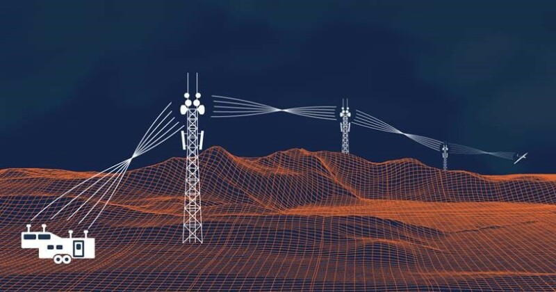
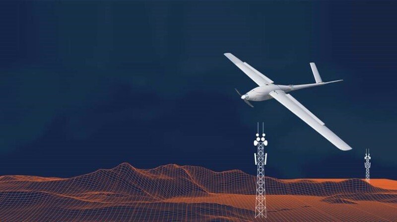
The Northern Plains UAS Test Site in North Dakota has teamed up with companies and agencies like Airspace Link, North Dakota DOT, and Thales to implement and test one of the most unique drone ecosystems in the U.S. North Dakota is making significant investments in critical infrastructure to enable safe, scalable BVLOS UAS operations. The intent is to stand up a viable BVLOS operational network that will show just how America can implement a standardized, accessible, and repeatable system for state-wide drone deployment, which will ultimately enable new industry applications and create new jobs required to invigorate and modernize our approach to infrastructure and adoption of new technologies. The test site is working in lockstep with the FAA to obtain the necessary authorizations for this system and is running the VantisUASTM initiative in parallel with the FAA BEYOND program.
“What we are really trying to accomplish is to lower the barrier for advanced UAS operations into a single network that multiple users can take advantage of to meet their needs to fly beyond visual line of sight,” explained Nick Flom, Executive Director of the Northern Plains UAS Test Site, to Commercial UAV News. “We look at this as an opportunity for jobs, innovation, and technology, not only at the state level but at the local and tribal level. We are going to be able to figure out how we can do this type of integration, what tools are needed, and the types of challenges that present themselves, and that is going to help a lot of other people replicate this process.”
To provide a deeper dive into how this program is set to enable America’s approach to drone technology, we spoke with members of the team involved in implementing and testing this program to find out the key components that is driving their methodology and approach, the broader implications and applications of their project, and more.
Why BVLOS Is Integral to Scaling
There is money to be made today in the drone industry, and this will only continue to grow. Visual line of sight operations has enabled a lot of service providers to deliver value for their customers and agencies in many ways across many sectors. But there are still a lot of high-value clients waiting in the wings to see regulations open up, especially in the agriculture, energy and utility, and transportation space—industries that are often funded or supported by state, local, tribal, and federal governments. These sectors have assets that span hundreds, if not thousands, of miles that need better solutions than traditional methods, which are costly, dangerous, tedious, and inefficient. And in scenarios where BVLOS has been approved, drones have proven time and again that they are the ideal cost effective, safe, and efficient solution.
Despite this, the stringent requirements for obtaining BVLOS waivers is a deterrent for those that could benefit significantly from scalable UAS applications. The cost of entry has been too steep and time consuming to be worth implementing. The VantisUASTM program is on track to change this by investing in shared use physical and digital infrastructure that will support many industry UAS applications.
“When we look back at the early predictions of the industry, there was a lot of buzz around drones disrupting a lot of industries, especially agriculture, but we don’t see a lot of UAS operations happening right now in agriculture,” pointed out Flom. “This may be oversimplifying it, but when I fly visual line of sight, I can cover hundreds of acres an hour; but when I can fly beyond visual line of sight, I can cover thousands if not tens of thousands of acres an hour. We don’t have that scalability component with visual line of sight. For example, for a linear inspection, if I have to fly that visual line of sight by the time I’ve taken off, landed and gone to the next spot, I probably could have driven or found a different way to conduct that inspection—I can’t scale my operation that way.”
The State of North Dakota is committed to changing this scenario in a big way. Understanding that lowering the requirements for BVLOS waivers with the FAA is necessary for adoption, North Dakota is looking at what they can build and develop as a state-wide service to reduce that burden. The results are promising for scaling operations beyond visual line of sight and could one day provide the blueprint for other states and countries around the globe.
“We’re seeing incremental steps that are already making a difference,” stated Flom. “We’ve been able to demonstrate operations with precision agriculture flying at 15,000 feet doing 10,000 plus acres an hour. With the IPP program, and now the Beyond program, we are able to put this system in place with the support of our state.”
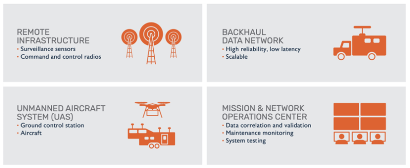
One of the key components that is enabling VantisUASTM is infrastructure.
Why We Need Drone Infrastructure
There is a lot that goes into securing proper clearance for BVLOS and other advanced operations. In order to get a waiver to fly a mission BVLOS, everything needs to be purchased, tested, and proven through ample data gathering before it will be approved by the FAA, and it is usually on a mission-by-mission basis. North Dakota sees another path that leverages existing infrastructure and builds out an integrated state-wide system to support advanced drone operations.
“Each and every time somebody wants to fly beyond visual line of sight it is bring your own equipment, bring your own surveillance, bring your own platforms, bring your own ground control system, bring your own communications, and so on,” explained Frank Matus, Director of Digital Aviation Market Development at Thales, who is bringing decades of aviation experience to help North Dakota with systems integration. “A section of airspace is then cordoned off in order to ensure that the airspace is completely sterile of manned aviators. This model isn’t scalable. By looking at the network as a whole system, in which you are able to leverage services from the state to fly, VantisUASTM will help unlock the true potential of BVLOS. Stakeholders no longer have to go off and invest in aviation or surveillance-related technology that isn’t part of their core business. They can take advantage of the network and realize their return on investment.”
In order to accomplish a lot of this without breaking the bank, North Dakota is working with their DOT to find ways to leverage existing infrastructure and update it to support drone operations.
“There is a lot of infrastructure already out there,” explained Russ Buchholz, Innovations and Facility Manager at NDDOT, who has been with this project since its beginnings in the IPP program. “We’re looking at how we can leverage that existing infrastructure to provide what is needed to support this program by working with other government agencies like the DOT.”
The final result of providing this infrastructure with VantisUASTM is the democratization of the airspace for advanced operations. Because the state has already gone through the process with the FAA to ensure proper air and ground tracking, management, risk mitigation and so on, obtaining advanced operation waivers become a lot less cumbersome because they are accessible to all and, most importantly, repeatable.
Drone Processes Need to Be Replicable
A major factor in whether the FAA will grant a waiver to fly BVLOS is predicated on the ability of the applicant to build a convincing safety case, which requires a lot of data. This process becomes a lot smoother when processes, technology, and standards have already been proven reliable in real world operations. In theory, if the FAA has already granted a waiver or authorized similar operations that leverage the same infrastructure and systems, there is a precedent set, which makes it easier for the next operator to make their case and get to market more quickly. This approach that is being taken in North Dakota to provide shared use infrastructure will help the industry scale.
“From a user perspective, they want consistency and continuity and not a patchwork quilt of different systems, configurations, and datasets to have to use every time they setup in a new location. I think that clear performance-based criteria along with consistency in the data models and performance measurements will go a long way toward helping streamline these approval processes,” explained Lisa Peterson, VP of Business Development & Marketing at Airspace Link, Inc., who is in charge of providing ground risk assessment data for the VantisUASTM system and more. “If you can rinse and repeat, this is how you reach scale. We are doing as much as we can to normalize the process in North Dakota and across the whole U.S. This should also help set the stage for streamlining the regulatory approval processes.”
Community Engagement Is the Lynchpin
So why did this happen in North Dakota and not other states? The major component that distinguishes North Dakota from many of the other states was support at the legal, governmental, and community levels. None of this could have been made possible without the support of these communities and entities in North Dakota. From state, local, and tribal governments to individual citizens, the communities in North Dakota understood the value of the investment, and this is because leading members of the program spent time with stakeholders.
Drilling down to this level of engagement is an element that can be easily overlooked but was critical for the success of North Dakota’s program and it was integral that the partners they connected with were able to support that mission. For example, Airspace Link has an established history of providing solutions to DOTs at every level – state, local and regional metropolitan planning organizations. By ensuring that they and their partners are working at all levels of the state, North Dakota is ensuring the system will work for everyone who will need and benefit from it.
“This is an example of state, local, and tribal governments working together,” explained Flom. “We have a forward-looking governor who really supports this initiative. He believes in a whole of government approach and looks at this initiative as something that is going to help out the state of North Dakota. It is going to help our state agencies, our DOTs, and first responders who are understaffed in rural areas of the state. It is going to help from a safety standpoint. If we’ve learned anything in the last year, is how we need to prevent avoidable trips to the hospital. Rural medicine was already a challenge in North Dakota, we can use drones to make that and other systems and processes better.”
Conclusion
North Dakota is demonstrating what it means to fully utilize the capabilities of drone technology for the maintenance and preservation of our infrastructure by working to lower the barriers to beyond visual line of sight for its communities. Though each state is ultimately going to have different motivations that will inspire them to look into drone technology, what we discover through North Dakota’s program will be able to inform how we can approach advanced operations at a national or even global scale.
The key is to find what matters to your state and communicate it across all levels of the community. How these arguments resonate with the needs and challenges of a community will point to where infrastructure and other services have been failing them and how drones can be of the greatest use to the community, whether that is to provide jobs, improve transportation and delivery networks, provide better utilities, manage sustainable crops and natural resources, support public safety efforts, reduce carbon emissions, or one of the many other services drones can provide.


Comments