

One thing you hear over and over in the drone industry is how fast the technology changes and evolves. Stakeholders have justifiable concerns that by the time they’ve made the effort to integrate a given solution, the technology will already be outdated which will put them in an endless upgrade cycle. However, looking at the adoption of this technology in such a limited way ignores the value it can create in present while opening various opportunities in the future. Those limitations are especially true when it comes to the opportunities the technology has already been able to define for specific applications like surveying.
Case and point is the LiDAR vs photogrammetry for aerial surveying debate that is still being waged. We’ve outlined how and why the discussion shouldn’t be about choosing one over the other, but instead about how and where these solutions can compliment one another, and how deciding which is “best” all depends on details that vary by project and application. These nuances are explored in detail in Skyward’s new photogrammetry training course for commercial drone programs, but how have changes to the technology changed the approach that professionals might be able to take? What can students expect to learn in this workshop, and how are professionals across the industry answering these “LiDAR vs photogrammetry” questions to create value?
 To find out, we connected with Diego Barrera, Director of Professional Services for Skyward, A Verizon company. He provided answers to all of those questions and more, defining what it can mean for operators of all types and sizes to create real value with a drone program.
Jeremiah Karpowicz: Drones are increasingly being recognized as an ideal tool for photogrammetry. Can you tell us more about the process and what it’s being used for today?
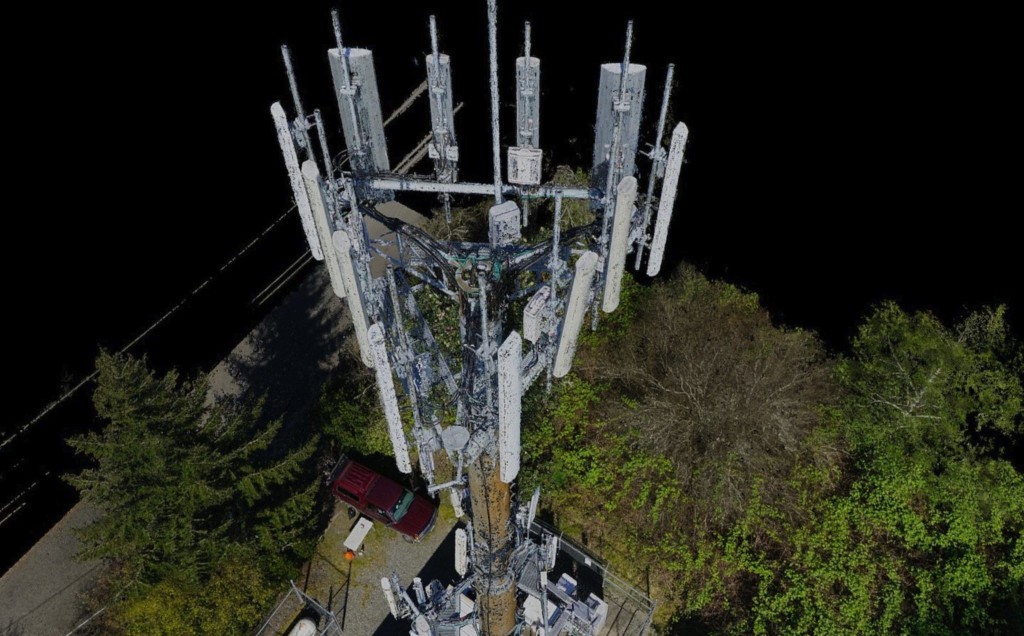
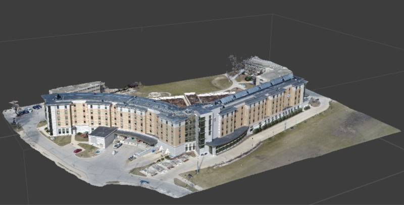
Diego Barrera: Specifically, photogrammetry is the process of collecting geo-referenced, two-dimensional images and using software to stitch them together into two-dimensional (2D) maps (orthomosaics) or three-dimensional (3D) models. A processing engine uses location data associated with each image to identify the overlap between images. Using this data, the engine estimates the third dimension of topographical areas and vertical structures. The output is a 3D point cloud and photorealistic mesh that serves as a digital representation of the area or structure being surveyed. Teams can use this to gather measurements, inspection criteria and other valuable insights.
We’re seeing more drone programs using drones to produce 2D maps and 3D models via photogrammetry, this includes creating renderings of buildings, job sites, infrastructure and more. In addition, the models produced by photogrammetry are being used in applications ranging from building information modeling (BIM) and stockpile calculations to terrain surveys and infrastructure inspection.
Today, most modern drones are equipped with high-quality cameras and use GPS systems to provide accurate location data. These capabilities, paired with an aerial perspective, make drones ideal for photogrammetry surveys, and drone programs can recognize the benefits of photogrammetry right away. In many industries, aerial mapping and 3D modelling can be part of the value proposition when calculating the return on investment (ROI) in a drone program, but successful photogrammetry requires safe operation of the drone and effective collection of the imagery. And learning to do that while avoiding a significant amount of trial and error requires training, which is what Skyward can provide to our customers.
How is Skyward supporting this trend for customers?
We know photogrammetry can be a complicated, technical topic. To help our customers get more value out of drones, we introduced a new mapping and modeling training course. Led by our team of drone experts, Skyward’s photogrammetry training course is a one-day workshop designed to equip drone pilots with what they need to help drone programs go from no experience to producing high-value deliverables. Customers in media and telecommunications are putting Skyward’s photogrammetry training to work and quickly producing products that are valuable to their businesses.
The program is available as a standalone course, or our customers can add it to Skyward’s Program Start package, which equips companies with the policies, equipment, software and training that can help them launch a high-value drone program and achieve value quickly, to get a group of drone pilots up and running in just weeks. In addition, the training can be conducted using a free trial of a photogrammetry processing engine or customized with a company’s tool of choice.
What’s the biggest misconception people have when it comes to sorting out whether photogrammetry or LiDAR is the right solution for a project?
There are benefits and tradeoffs to both systems, and LiDAR is not, in all ways, superior to photogrammetry. LiDAR employs very precise active sensors that generate 3D point clouds by bouncing light beams off of all objects in a scanned area. The light rays can penetrate vegetation to model underlying elements that go unseen by passive, visible light sensors found in aerial cameras. However, LiDAR is a big investment. Equipment costs are generally higher, as is the cost in training employees to use the equipment competently and adapting workflows to accommodate LiDAR-generated point clouds. On the other hand, companies using drones to take pictures and video for non-modeling purposes are already equipped to broaden the scope of their drone operations to include modeling with the same equipment and some additional photogrammetry training.
Companies should first consider the output required and work backwards from there. Some reasons to use LiDAR might include modeling a forest bed under tree canopy cover or accurately detecting smaller items such as power lines, which photogrammetry may not model as accurately. Photogrammetry is superior in its ease of use and ability to transition from non-modeling uses of drones, and the colorful images produce photorealistic mesh overlays for the approximated 3D point clouds, making it easier to contextualize the output. Generally speaking, photogrammetry can also be several times less expensive than a LiDAR system.
How many of the issues that people run into with “photogrammetry vs LiDAR” are on account of not identifying what kind of data they really need?
With so many options for drone systems and sensors capable of LiDAR or photogrammetry, it can be overwhelming to choose the right system. Remember that these are tools, and the initial focus should be on what output your organization needs. From there, look for the minimum system needed for your organization to learn and realize ROI while positioning the program for scale. Benefits of using the smallest and lightest-weight viable drone and payload include:
- lower cost, enabling you to achieve ROI sooner
- portability
- ease of deployment
- less operational risk (from having lighter-weight systems)
In many cases, simultaneously collecting and combining both images and LiDAR will yield the best, most accurate mapping solution. Is the ability to do so different or distinct from how you were able to capture this info in the past?
While this statement may be true, the underlying assumption here is that this is common practice, which is far from the truth, especially when considering companies that are using drones for the first time or considering investing in them for aerial mapping and modeling. Combining photogrammetry and LiDAR is often reserved for engineering-grade work because the end products are more accurate — they combine the accuracy of LiDAR-generated point clouds wrapped with a photogrammetrically-generated 3D mesh. However, combining the two modeling technologies will cost more than employing one system or the other, and carrying the dual payload will require a bigger drone, which is more expensive and risk-prone.
When combined with accurate use of geo-rectification methods like ground-control points, real-time kinematic and post-processing kinematic, the accuracy of photogrammetrically-estimated point clouds are getting closer and closer to matching the accuracy of LiDAR-calculated point clouds.
Is there any downside to this simultaneous capture of information?
Combining the two modeling technologies will cost more than employing one system or the other, and carrying the dual payload will require a bigger drone, which is more expensive and risk-prone. Also, combining the two distinctly different model outputs (the LiDAR cloud and the photo mesh) requires more expensive post-flight processing to align the two.
Can you walk us through Skyward’s photogrammetry training workshop? What can students expect to learn?
Our new photogrammetry training course teaches participants how different camera elements affect both the quality of imagery collected and the model created. Students also get hands-on practice with Automated Flight Modes in Skyward’s InFlight mobile app, learning to capture the necessary imagery with survey operations. This data collected can then be ingested into the customer’s preferred processing engine to build high-quality 2D maps and 3D models.
Skyward’s photogrammetry training is designed to streamline a drone program’s path toward ROI and strengthen the value of drones across a company. In combination with Skyward’s Program Start package, this training can fast track a drone program to full-scale operations and better results.
What are some of the questions that people should be asking when they’re making decisions about utilizing photogrammetry and/or LiDAR for a project? Is there baseline advice you’d offer to anyone sorting through these challenges?
The initial focus should be on what output you and your organization needs. From there, look for the minimum system needed for your organization to learn and realize ROI while positioning the program for scale.
Beyond that, here are some specific questions to ask when making these decisions:
- What level of accuracy is required by the end users of my map/model?
- Is a photorealistic 3D mesh required?
- What is my budget?
- What technology is the best fit for the capability of my operators, data processors, end users and company?

.jpg.small.400x400.jpg)


Comments