


Earlier this month, professionals from the geospatial industry, experts in airborne and terrestrial data capture technologies, and built world professionals came together in Denver, Colorado for the 2024 edition of Geo Week. The annual event highlights the newest and most innovative technologies for these sectors, on both the hardware and software side, and exemplifies how all of these spaces are converging at a rapid pace through fascinating panel discussions and informative presentations throughout the three-day event.
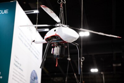
“Convergence” was the one word that Dawn Zoldi came away with, as she explained in a recent article on Commercial UAV News highlighting her experience at the event. She notes the wide variety of technology that is showcased at the event, ranging from software solutions, to massive scanning systems designed for crewed aircraft, to ground-based robots, and so much more. That said, UAVs certainly had an outsized presence throughout the event in multiple ways, as demonstrated below.
UAVs throughout the show floor
Walking through the show floor, which included 200 exhibitors, there was a bevy of technology on display, but it was clear that drones dominated the space. Part of it is simply the nature of the technology – it goes without saying that a drone is going to stand out more than, say, screens showing a demonstration of new software – but it was also just the sheer number. Just walking through the main entrance, you were immediately put in front of payloads for UAV surveying with sensors from RIEGL, and not far behind them was WISPR Systems’ booth, which showcased their new SkyScout drone.
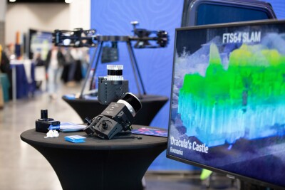
And that was just the first couple of things on display when you first walk in. Walking through the rest of the event’s largest-ever show floor, there were more drones and payloads seemingly everywhere you turned. Essentially every type of drone you could think of was on the floor as well, with multi-rotor systems, fixed wing, and fixed-wing VTOL drones. There was also a plethora of payloads to collect data with all of these different drones, ranging from scanning systems mentioned above, to camera systems from companies like Phase One, to software solutions needed to process all of this data, like 3Dsurvey’s solution for photogrammetric workflows. If you had any interest in drone-related workflows in the geospatial realm, you were sure to find what you were looking for walking around the floor, and chances are it didn’t take long to find it.
Opening new avenues
Walking through the show floor was certainly eye-opening as to the presence of UAVs throughout Geo Week 2024, but as someone who spent most of their time in sessions, it was these times where the power of these systems really shone through. Throughout so much of the event, those inside the industry highlighted all of the fascinating ways their UAVs are being used to capture data.
In fact, there was an entire session that highlighted the unique projects people throughout these industries were working on, and drones played a heavy role throughout these presentations. Ron Krawczyk, for example, talked about how his company used UAVs to find “orphan wells,” which are from the pre-World War II era and can pose health risks to surrounding communities. Alex Fraess-Ehrfeld, meanwhile, highlighted how drones combined with AI are being used to inspect the growing number of solar panels, while Saulius Zaura used drones to create 3D models of windmills throughout Eastern Europe in countries like Lithuania, Latvia, and Estonia.
In a separate session, DJI’s Kyle Miller highlighted the way their UAVs, payloads, and software were used to help uncover secrets of ancient Mayan Civilization in Central America. Yet another session was all about the ways surveyors are using drones in their workflows, with examples ranging from redesigning a golf course to surveying in the Grand Canyon. All throughout the week, it became more clear that the use of drones is opening up so many new project possibilities for surveyors and other professionals all around the world.
UAVs have moved out of the niche
While those previous tangible examples were certainly hard to ignore, coming out of Geo Week what really stood out regarding the drone surveying space was more intangible. That’s the fact that drones are now fully integrated into the geospatial industry. It would be disingenuous to say that this is a completely new development, as drones have long been embedded into these workflows, but there is a different feel to it now.
For a long time, it was seen as a new tool that surveyors should try, and that was how the conversations around the technology were generally framed. Now, though, that connotation has begun to shift, treating UAVs like any other traditional surveying tool. Drones are, to put it simply, a crucial and often expected part of the workflow. That’s not to say there isn’t tremendous growth in this space, because there are still plenty of surveyors who have yet to really dive into using UAVs, but the way people talk about it has shifted in a way that shows the power of drones and the possibilities their implementation opens have been recognized.


Comments