


Geo Week stands out as the foremost gathering facilitating enhanced collaboration among built environment experts, advanced airborne/terrestrial technologies and commercial 3D technology enthusiasts. Originating in response to the evolving demands of professionals in the built world and geospatial sectors, it recognizes the ongoing fusion of technologies. Positioned at the heart of the current transformative landscape, Geo Week serves as the nexus for pivotal developments in new technological advancements, including automated workflows and hardware breakthroughs. Read on for a scan of the event (pun intended).
One Word: Convergence
Trend #1: Send in the Robots
 Drones dominated the show floor this year. WISPR Systems unveiled its groundbreaking SkyScout drone, weighing just 4.7 lbs, it features an impressive flight time of 26-30 minutes with smart, hot-swappable, plane-safe batteries and a failsafe mechanism for safe, uninterrupted operations. Equipped with Here4 and HerePro GNSS antenna options, the drone offers precise RTK and PPK geo tagging capabilities for accurate data collection. The SkyScout offers five payload options that come complete with a custom quick attach designed in coordination with Gremsy. These payloads are the 24MP WISPR Mapper, Sony ILX-LR1, Gremsy Zio, Gremsy Vio and the RESEPI WISPR M2X LiDAR. (For a rundown of drone tech at the show, check out this DroneLife article.)
Flying robots were not the only eye-catchers. The swimming ones were equally impressive. CHCNAV’s hard-to-miss bright yellow APACHE 3 Pro USV (uncrewed surface vehicle or USV), a compact hydrographic “drone,” with a single beam GNSS/INS technology, enables advanced bathymetric surveying. In the event of GNSS signal loss, such as under bridges, the APACHE 3 Pro retains its course using autonomous navigation. Other autonomous features include its cutting-edge millimeter-wave collision avoidance system that can detect obstructions within a wide 110° angle ahead, which plots a detour course when it encounters an obstacle. Its light frame (only 10kg), combined with a semi-recessed motor and internal rotor motor design, contribute to a shallower draft which translates into easy maneuver through diverse water depths. Importantly, a D270 single-beam echo sounder standard feature also incorporates a built-in water temperature sensor that facilitates real-time sound velocity correction to account for temperature fluctuations for exceptional depth measurement accuracy.
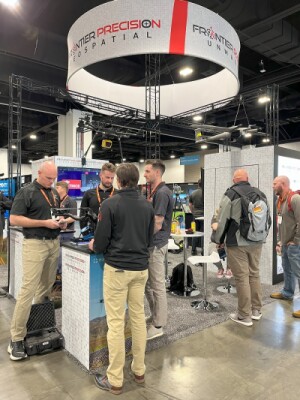 It seems like lately every tech show has a “Spot” Q-UGV roaming the floor, and Geo Week was no different in that respect. Not only did we see Spot taking his daily walks, we also found him at rest in the Frontier Precision and Exyn Technologies Booths. In the geospatial world, companies are working hard to fit Spot with their latest sensors (more below), such as Exyn’s new Nexys, a fully modular and autonomous 3D solution for the most demanding surveying and inspection environments. When affixed to Spot, its Autonomy Level 4 (AL-4) features enable intelligent autonomous navigation and mapping in dynamic, complex surroundings and GPS-denied areas. It achieves unparalleled data capture speeds and instant point cloud colorization through the integration of cutting-edge LiDAR technology and the company’s exclusive SLAM algorithms as well as real-time visualization of detailed, colorized data directly onto a 3D point cloud (up to 1.9 million scan points per second with survey-grade accuracy up to 5mm @ 1 sigma) using hemispherical cameras.
From the floor, Ben Williams, the Exyn Technologies’ COO said, “We are especially excited to get the Exyn Nexys in the hands of survey teams everywhere. The improved modularity and performance gives those teams a leap forward in speed, accuracy, and flexibility to accomplish their jobs. We're looking forward to helping push the bounds of what's possible in mobile mapping and autonomous data collection with the help of our customers and partners across the industry!"
Trend #2: Heads and Workflows in the Cloud
3Dsurvey’s photogrammetry software (newly released version 2.18) offers a robust solution for processing geospatial data derived from various sources such as drones, LiDAR, sonar, GNSS, and terrestrial images. The company introduced 3Dsurvey Cloud to enhance project collaboration and management and allow for easy data upload, intuitive project comparison and ease of sharing through links. This facilitates enhanced client engagement with detailed analyses and interactive tools. It also features an integrated CAD engine that streamlines the workflow and enables direct CAD detailing on aerial images from 3D modeling; advanced layer management that seamlessly integrates it with existing workflows for project consistency and efficiency; and versatile tools for 2D and 3D mapping, volume calculations, cross sections, profiles and contours.
In the GIS software class, Blue Marble Geographics released version 25.1 of its Global Mapper Pro, part of its larger suite, at the show. A cost-effective and user-friendly GIS data processing application, this software goes beyond basic utility by incorporating advanced features such as distance and area calculations, raster blending, spectral analysis, elevation querying and more. With an intuitive interface and logical layout, users can quickly achieve efficient data processing, accurate map creation and streamlined spatial data management access to a wide range of spatial datasets. The software can be directly deployed within organizations and evolves with changing needs to alleviate the need for costly extensions or modules. The company also provides comprehensive support, for a complete out-of-the-box solution.
These are but a few of the many outstanding software solutions highlights at this year’s event.
Trend #3: Sensors and Sensibility
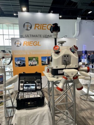 Industry goliath Riegl announced its new Riegl VQ-860-G high performance topo-bathymetric airborne laser scanner at the show. Improves the ability to penetrate depths when surveying inland and nearshore waters, boosting efficiency in bathymetric tasks. The entire system comes with the option of integrating a factory-calibrated INS/GNSS system and a digital camera for enhanced functionality. The system offers outstanding depth performance, supporting a wide operational span of flight altitudes from 75m to 600m, with enhanced accuracy, speedy measurement rates and scanning speeds (up to 100 kHz and up to 100 scans/sec, respectively), precise ranging and multi-target capability using echo digitization and online waveform processing. Its compact and robust design ensures durability, while large internal storage capacity and optional integration of an INS/GNSS system and digital camera provides for high autonomy. With a weight of just 15 kg (33 lbs), it's possible to integrate this device into drones.
Reigl wasn’t the only big geo-focused company to show. Trimble (who sponsored a killer happy hour and announced a drone-related partnership with DroneDeploy for commercial mapping), N|V|5 (who had Moscow Mules flowing in their booth) and many others were also there in full force. PhaseOne showcased its new compact, lightweight (weighs under 700 g), power-efficient and P5 sensor and camera drone-based surveying payload integrated on Quantum Systems’ Trinity Pro, a next-gen fixed wing eVTOL drone.
 Then there were the smaller guys, like digital twin industry expert Matterport, which displayed its Pro3 LiDAR camera in the Carahsoft booth with distribution and solution integration partner Arcadus. Delivering unmatched 3D visual clarity, Matterport’s Pro3 enables digital twins that streamline project management across every phase of design and construction. Ideal for large indoor and outdoor areas, this latest LiDAR camera boasts unrivaled speed and an extended range of 20 meters. In addition to its own cameras, Matterport’s digital twin software solution is compatible with several others, including Leica Geosystem’s BLK360 G1, to capture a given space in 3-D. Matterport also offers plans to create immersive 3D experiences (including on mobile devices), from capture, to sharing to virtual reality (VR) tours.
Matterport advocate, Javan Clark, Co-Founder of Arcadus said, “For many of our public sector and regulated industry customers, Matterport's platform achieves the right balance of cost, capability, and ease of use. No single device or vendor offering can ideally serve all scenarios, and Matterport fits nicely in the middle market between promotional virtual tours, and high-end AEC/survey-grade use cases.”
By the way, digital twins permeate the ACE sector now. They reduce travel and time costs by 50%, survey costs and BIM file creation by 70% and site visits by 75%. This translates into a 30% reduction in cost and time saves and a 75% resolution of project issues without escalation.
Speaking of digital twins and Leica, we ran into Frank Collazo, the company’s Autonomous Reality Capture Consultant for the U.S. and Canada at the Hexagon booth. His comment: “Leica has pretty much all environments covered for your digital twins with their fleet of BLK autonomous sensors - the BLK2GO, BLK2FLY or BLKARC - from underground mines, dangerous plant environments and other hard to reach and inaccessible places. And the processing is seamless across our entire suite.”
Trend #4: Here to Serve
Situated next to Carahsoft on the floor, Austin, Texas-based SAM-Construction Services, the nation's largest provider of geospatial and inspection services, helps businesses reimagine their infrastructure strategies through its Managed Geospatial Services™ (MGS) digital ecosystem. The company’s network of over 1,600 professionals researches, locates, inspects and digitizes infrastructure assets and surrounding environments. These experts provide leaders with actionable intelligence by leveraging high-precision geospatial data from a wide-range of cutting-edge technologies, such as high-density terrestrial, mobile, and airborne LiDAR, image solutions, 3D scanners, and advanced instruments to gather enriched geospatial data for applications like BIM, Digital Twins, 3D Reality Models, and GIS.
Across the expo hall floor, Allen & Company, Inc. highlighted their technology-driven company surveying, mapping, and geospatial services. Focused primarily on serving Florida and the Southern U.S., Allen’s dedicated teams offer drone aerial mapping, 3D modeling, laser scanning, building information modeling, digital twin technology, AR/XR visualization, and GIS point cloud data acquisition services. The company caters to a diverse range of industries including architecture, engineering, construction, development, commercial real estate, healthcare, resorts, theme parks, and various other sectors across the United States. (And, fun fact, had one of the coolest swag offerings of the week: a whiskey glass featuring intricately sculpted mountains built into the bottom!)
Trend #5: Gadgets Galore
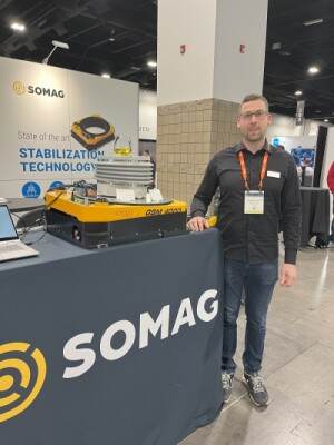 SOMAG, a world market leader in aerial photogrammetry stabilization platforms, highlighted its AG Jena, the company’s latest high-precision gyro stabilization mount, by showcasing it in action with a half-full wine glass sitting atop (barely moving, by the way!) This multi-domain gyro stabilization device offers a range of key performance-optimizing features including: stabilization accuracy (sensor movements reduced, on average, by a factor of 50); compatibility with existing airborne sensor systems for integration into various setups; a passive vibration isolation ring that decouples high-frequency vibrations (>15 Hz) for enhanced stability; and compatibility with popular Inertial Measurement Units (IMUs) and Flight Management Systems to allow for remotely controlled operation and improved stabilization performance. SOMAG
Just as no tech show is not complete without a Spot Q-UGV prancing around the expo hall, a geospatial show is not complete without someone mapping the place with NavVis’ wearable mobile mapping system - in this case, the company’s VLX 3. The NavVis VLX 3 efficiently provides laser scanning professionals with extensive 3D measurements and 360º images. According to Noah Johnson, the company’s U.S. Business Development lead, NavVis’ secret sauce: “Our proprietary SLAM algorithm mated to four cameras and two 32-layer lidar sensors ergonomically mounted to a carbon fiber exoskeleton, delivers the best combination of speed and accuracy on the market.” (Watch NavVis and other industry leaders discuss Geo Week on the Full Crew live from the expo hall floor: https://www.youtube.com/watch?v=MW4GuQPo1HI)
Zoller+Frohlich (Z+F) showed off its equally cool wearable scanner, the FlexScan. Designed as a mapping SLAM platform for mobile applications, the FlexScan can efficiently achieve highly accurate measurements from various angles. The target markets for this product include time-sensitive or large-scale applications such as AEC, facility management, process industries, heritage documentation and forensics.
Isaac Barreto, Z+F’s Laser Sales Engineer, told us, "The FlexScan is pushing the envelope in the reality capture space by taking the accuracy of a static terrestrial scanner and making it mobile while keeping that millimeter accuracy.”
The Sky is Not the Limit
This article just skimmed the surface of the companies and Geo Week… and the world of possibilities that they open for all of us. Learn more at Geo Week.


Comments