

The innovative ways drones are being used to collect information that would otherwise be difficult or impossible to gather are as impressive as they are revolutionary. Drone technology has been used to enable high accuracy mapping, but it has also been used to study the health of whales without ever coming into physical contact with the creatures. These use cases illustrate what can happen once professionals in various fields get their hands on the technology and actively consider what can be done with it.
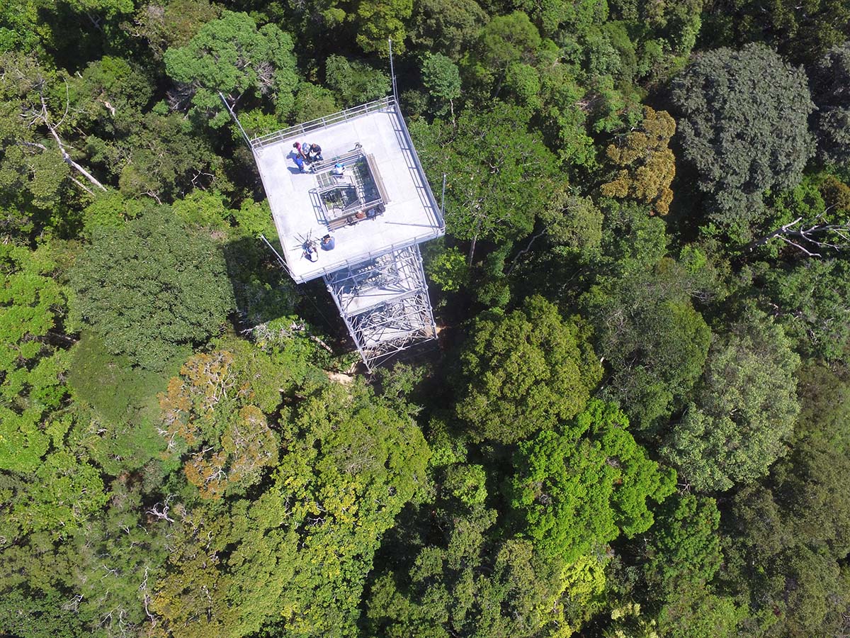
Dr. Scot T. Martin has demonstrated what’s possible with drones on a whole different level though. As an environmental chemist focused on measuring emissions from both vegetation and human activities in various ecosystems, he has traveled all over the world to study the connection between emissions and climate. Thanks to a strong collaboration with Amazonas State University (UEA), he’s recently been able to deploy drones for this work in the Amazon Rainforest, deep in Brazil’s remote Amazonas state. There, he has been utilizing drone technology to measure the Amazon’s air by “sniffing” the environment using sensors specially designed and built by members of his lab. Doing so has provided his team with insight never before available around the ecosystem of the Rainforest.It’s impossible to overstate the importance of this work, which is being supported by the Harvard Climate Change Solutions Fund, since it has and will provide a more meaningful understanding around how this environment is changing. The success Dr. Martin has had with the technology has compelled him to deploy a fleet of drones to collect air samples at different heights. This information will not only provide scientists with more accurate information but could help create an early warning system for potentially disastrous changes to the Rainforest.Many of these insights will be discussed by Dr. Martin at the upcoming DJI AirWorks event, where the Gordon McKay Professor of Environmental Sciences and Engineering and Professor of Earth and Planetary Sciences at Harvard University is set to present. To highlight his work and some of the things he’s set to talk through in detail at the event, we caught up with Dr. Martin for an interview. We discussed how his team is using drones right now, what kind of a difference doing so has made for his research, what he’s looking forward to discussing with participants at the AirWorks event and much more.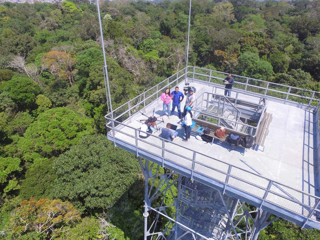 Jeremiah Karpowicz: I wanted to start this interview with a question about your line of research, but since you’re out in the Amazon Rainforest as we speak, maybe it’s better if you tell us how and why the approach you’ll be taking with drone technology to gather info on this very trip has been so significant? Dr. Scot T. Martin: The first thing to understand is that we rarely have a camera on the drone. What we're trying to do is collect samples, so the camera is off the drone and is replaced by our own sampler box.We’ve adjusted the interface of the onboard DJI computer so that it can communicate better with the tablet to control the sampler box that we’ve mounted to the drone. Once we mount this electronic nose to the drone, we use it to fly it around and sniff the forest.This opens up numerous applications in the environment, and we can also use different types of sampler boxes. It’s actually led to a cottage industry of sorts, and there are groups around the world developing these boxes. The M600 from DJI has basically become the standard, which has allowed us to agree on a standard box design so we can swap sensors on and off to gather the type of info that we could previously only collect from a tower or airplane or tethered balloons. The flexibility of the drones has opened up a whole new set of possibilities for us. What more can you tell us about what it previously meant to gather this info via a tower or tethered balloon? What kind of a difference does the drone really make for you? In atmospheric sciences, our standard array of approaches is airplanes, tethered balloons, satellites and towers. Each of them has their place, but there are serious limitations associated with each of them.The data you can gather from a tower is great, but it’s also limiting. We’re trying to gather data that tells us what’s happening across the Rainforest, but if we’re only doing that in the areas where towers happen to be located, we have to make assumptions around how that applies to the rest of the forest. In an area like Amazonas, that's not a good assumption, because we’re dealing with terrain that goes up and down 100 meters, as well as areas that go from being water-logged with certain trees and certain ecosystems to dry land at the top of the hills. The types of trees and ecosystems that grow in those areas are much different.A tethered balloon is a nice idea but atmospheric sciences have basically given up on them because they are very difficult to control and very difficult to fly. Tethered balloons sound like a good idea, but they're actually very rarely used for a whole host of practical reasons.Aircraft is great, but if your science is 1 or 2km in distance, an aircraft isn’t an ideal fit because your aircraft is moving much faster than that. Satellite gives you a big picture of the forest, but you're looking at what might be between 5-10km resolution. Missing in this whole constellation in all of that is what a drone can do. Why is it so important to be able to collect data at that 1-2km level though? Does it relate to the assumptions you’ve previously had to make about terrain that is vastly different? Yes, and that’s partly because it’s very tempting to take a measurement around a tower and declare, "this is Amazonas." But guess where the towers are placed? They're placed in areas that are nice and what you call terra firma, with firm ground and tops of hills, so there can be a lot of bias in what we think we know about Amazonas chemistry and the types of things, and what the trees omit.With a drone, we can go out at that radius of 1-2km. We can sniff the various organic chemicals coming out over the forest and in the sand forest and all types of sub-forest ecosystems that make up the bio-diversity in the Amazon. The tree, besides exchanging carbon dioxide, exchanges a whole bunch of organic molecules into the atmosphere for a number of reasons. There's a dynamic exchange of organic molecules all through the forest if you could smell them. It really opens up a whole new dimension to study the heterogeneity of the forest and the forest emissions, what plants, what kind of organic compounds plants emit, how they communicate with other plants. That's the general thing we've been working on for about two years. Can you talk a little bit about the logistics of swapping out the camera system? In general, in atmospheric sciences, we're not engineering experts, but we bring along amateur engineering capability because we're used to building our own sensors for whatever purpose, because there are a lot of things you just can't buy. So we knew the kinds of questions we had to ask DJI when it came to this swap.The scale of things, the cost, software, etc. are all in the realm of what a talented university lab can do. It's not trivial, but at the same time, it's not something where you have to bring in a company to sort out. The M600 is very affordable, and once we figured out what it would take to get our sampler box attached to it, we were up and running in a way that is practical for the scale that university laboratories operate at.As we’ve expanded our use of drones though, we’ve realized we also want to have a camera in the air. Keeping one up there allows us to point the camera downward to see what stage of senescence the trees are at. That’s something we actually haven’t done yet, but we’re planning to see how that works in the next month or so. I’ll let you explain what senescence means, but what kind of a difference or distinction will that mean for your research? Most people know the temperatures and changes associated with spring and fall seasons, but in the Amazon, many trees are on their own clock. So some are getting their yellow leaves at a certain time while others are still fully green. It's a 365-day a year phenomenon. There are some dry-wet season differences, but many of these trees are all going through their annual cycles individually on their own clocks. We want to capture data associated with those cycles with the camera.By taking that second drone out, we can film the forest underneath. We have to get close to the forest because the atmosphere is turbulent, so the higher up you go from the forest, the more everything that gets emitted from the forest mixes and averages out. That's why we want to be down by that 10m level, and we can only be there with the drone. That’s a great example of a different approach you’re able to take thanks to drone technology, but what kind of a difference does that make for your research as a whole? Does it or will it enable a bottom-line difference? There are probably five or six stories I could tell there.The Amazon is under stress, both from things the Brazilian government can control, which includes things like development and deforestation, along with things that are out of the Brazilian boundaries, which are issues like global climate change and changing rainfall patterns. What does that all mean to the forest though? The forests are emitting all these various organic chemicals for different reasons, some of which are stress factors. We know when they get under drought, the emissions change. Knowing when those changes are happening is going to help us avoid a disaster scenario. I’d say that’s a big difference. What more can you tell us about this disaster scenario?It’s a scenario for the Amazon forest called the "tipping point". In the Rainforest, the rain supports the plants, but the plants then re-emit the water and make the rain. The problem is that if you take down enough of the forest, that feedback is negatively impacted. The more forest you take down, the less rain you have, and on it goes. If you take down enough of the forest you’ll reach a tipping point which directly leads to the savannization of half the Amazon forest. That’s the disaster scenario.Could we have some type of early warning system for this by being able to smell the forest? So we'd know if we're passing into that regime or not? If you’re sniffing out and identifying the different concentrations of emissions and levels they’re at in a given plant or area, there's the possibility that we could develop this kind of an early warning system to identify when something drastic happens with those levels. So if the smell of the forest changes, so to speak, then we would know that the forest was undergoing some dynamic change, and probably not a desirable change. That's just one aspect of the stakes here though.In general, understanding why plants emit these compounds, what they're used for, and how they communicate has been hindered because we haven't been able to spatially map out which plants are emitting these compounds at which times and for which reasons. I call it the mesoscale with the drones. That's 1km-type resolution in the horizontal that has been missing.We've had the tower, which is a fixed location and we've had aircraft, which are 10km, but we've had this missing scale. The types of things we might discover and learn about the forest are really boundless because of this. How much from the research you’re doing right now in the Amazon will you be able to present and talk through at the upcoming DJI Airworks event? I'm not exactly sure yet, but that's the nature of science!I know I'll be showing some of the things we're doing in the Amazon, and then making the point that you can do a lot of interesting things if you don't have a camera. I think a lot of people look at a UAV and camera as being hand-in-hand and don't separate the two. Of course, there are different types of cameras, but I want to be able to show people the possibilities drones have with other types of sensors and samplers and with some of the things we have and are learning thanks to these devices. What are you most looking forward to doing or being part of at the event?My background is in atmospheric chemistry. I really only got started with anything to do with drones about two years ago. At the end of the day, we're chemists, so I'm interested in showing people at the event what we're doing with fleets of drones and exploring what direction we can and should take that in.For example, I know there are opportunities related to machine-learning for identification purposes, and with using sensors that can provide us with the same or better info than our sampler. With the sampler, we have to take stuff back to the lab and don't get the results until the next day. Sensors allow us to get results in real-time.Suppose we start using a sensor that smells something interesting. How would our drone correct itself in real-time to try and find the plant that's emitting that specific compound? What control would we have over those decisions? Those are the kinds of things I want to discuss with participants and attendees. More than anything else, what’s one thing you want attendees to know about the conversations you’ll be looking to have at the event? Drones are enabling us to do some incredible science, and I’ll always be much more interested in the science than I am the drone. So I want to connect with people whose interest is specifically in the drone, and the kind of data they can gather. I want to talk to people who are looking to solve problems with this technology. I have problems I need solved, and I’m excited about the possibilities when it comes to discovering what else we can adopt and develop with UAVs. Learn more about Dr. Martin’s work as well as a variety of other fascinating ways drones are being used to reshape the global economy at the upcoming DJI AirWorks event in Dallas, Texas on October 30th – November 1st


Comments