Issue #183 of California Surveyor featured a guest post from Daniel Katz at Aerotas, entitled “What You Need to Know to Determine If UAVs Are Right For Your Survey Business”. It’s a great look how UAVs are impacting the surveying industry right now as well as how they’ll continue to make a difference in the future.
In the article, Katz breaks down the basic UAV stack, talks through the deliverables UAVs can produce, discusses how those deliverables translate to real value and plenty more. You can read the whole article by
downloading the digital copy of the magazine.
Issues around what it does and will mean to legally operate a UAV under Part 107 is something we’ve
covered in general and
specifically for land surveyors, but I wanted to further explore a few of the things Katz mentioned in his article. He provided some more insight associated with the logistics around what using a drone will mean for land surveyors as well as how the
Aerotas Map Package can make a difference.
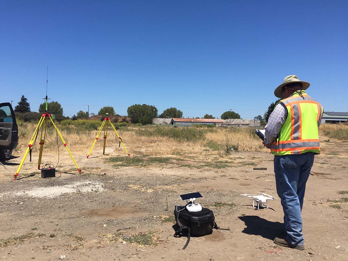
- Approach
The article mentions that most survey firms’ UAV operations involve three pieces of technology: a UAV with a camera, autopilot software, and image processing software. While complete drone solutions like the one Aerotas offers are out there and on the rise, many individuals and organizations end up putting these things together on their own, which can end up being both challenging and costly in numerous ways.
“When an organization tries to piece together a drone program themselves, they risk producing bad data, running an unreliable operation, and -- worst case scenario -- a crash,” said Katz. “Often when organizations try to take a DIY approach to drone operations, they don’t realize that they don’t know all the components that they need to put in place.”
It takes a lot of time, energy, and testing to identify which option for each component works best. An entirely separate set of configurations and tests then need to be performed to get everything working together effectively, reliably, and safely. That’s not to say DIY solutions can or won’t work, but surveyors need to consider the best approach around how they can leverage drone technology.
- Process
With so many people talking about all the different things that
drones can do for surveyors, it can be easy to think UAVs are set to completely revolutionize the industry. That’s why it’s essential to recognize the difference between the models and orthophotos put together from data captured by drones as compared to the models and orthophotos assembled by more traditional means, is practically non-existent.
“Fundamentally, the outputs from drones are no different from those of traditional means,” Katz explained. “The basic principles of photogrammetry have been around for well over one hundred years. UAVs, faster computers, and better processing software just means we can do it faster and cheaper. Every individual camera or software can have its own slight differences in process or calibration, but the fundamentals are the same as they have always been.”
Anyone who is convinced or is trying to convince someone that drones will inherently change what surveyors are doing is misinformed. UAVs are tools that can make surveyors more efficient and effective, but any surveyor that thinks or believes drones will inherently change their process should reconsider how they can and should use these tools.
- Processing Time
While a drone might just be another tool for a surveyor, it’s an especially powerful one. Many surveyors are able to complete a job in 60% less time than by conventional terrestrial methods once they’re familiar with this new process. How quickly can the data captured from that job actually be utilized though?
“An experienced operator with a good computer can process the raw data into a ground control corrected, georeferenced orthophoto and surface model in a few hours,” Katz mentioned. “However, it takes a significant amount of experience to reach that level of proficiency, which is why, when we get surveyors started using UAVs, we run the data processing for them as part of our
Aerotas Map Package.”
An orthophoto is utilizable immediately, as a backdrop to linework or for completing two-dimensional planimetrics. The utility of a surface model requires additional steps in order to refine the model and then complete the linework from the model. No matter the details, drones represent a more efficient approach by utilizing that faster processing time. However, being able to actually see that faster time depends on knowing how to take advantage of those possibilities.
-
 Deliverables
The article in
California Surveyor also lays out a number of details around the specific deliverables that most surveyors use a UAV to produce. Those three deliverables are a surface model, an ortho-rectified photograph, and individual photos and videos. While it’s evident where and how these three pieces of information are going to be relevant, how else can these deliverables be utilized for the benefits of the overall project?
“Orthophotos are valuable for planning, some planimetric drawings, putting behind drawings, and communicating the feel of the land to clients and stakeholders,” Katz explained. “Surface models enable surveyors to produce contours, breaklines, and full line work of all features. Both also serve as valuable records for surveyors, so that if a team misses collecting or mislabels a point in the field, the orthophoto and model allow them to pull that point digitally without having to make another trip to the site. We also see a lot of firms produce 4K video to produce marketing materials, or as client-pleasing bonus deliverables.”
There are plenty of creative ways that people are using drones as well as how they’re using the data that those drones are gathering. Orthophotos and surface models are and will continue to be the key deliverables for most surveyors, but there are clearly other options in terms of how surveyors can find and create value via the info UAVs gather.
- Savings
One thing you come across over and over when it comes to utilizing drones on a project is how they can represent a tremendous cost savings, and that usually comes down to a matter of man-hours. That was an item mentioned in the article as well, but I wanted to find out what those specific details were, because it’s essential to see how reduced man-hours can be directly correlated as a cost savings for a project.
“We recently helped a client map over 600 acres of very hilly and rough terrain,” said Katz. “It took two days to map by drone, compared to the weeks it would have taken terrestrially. On average from clients we hear about a 60% time savings on average projects, over terrestrial methods. Surveying a 10 acre plot conventionally takes a two-man team a full day -- 16 man-hours -- whereas the same job by drone would take a total of 6 hours, including set-up, flight, and processing.”
It’s easy to talk about all the savings a company could potentially see by utilizing a drone, but without ever getting specific it can be difficult to quantify exactly what those savings look like. As Katz mentioned in the article and fully explained above, whatever up-front cost a firm will face in procuring a drone program can easily be made up and further leveraged.
- Potential Pitfalls
There are clearly some very “standard” benefits that surveyors can expect to see when they utilize drones in an efficient manner that are associated with time and man-hours. What are some of the issues that can arise in this process though? Will operators encounter issues if they’re utilizing data that isn’t accurate?
“Bad data rarely causes a problem as long as there is an actual person reviewing the final output,” Katz mentioned. “The benefit of working primarily with photos is that errors are almost always apparent. Fully automated processing can often make mistakes, but those are obvious in the form of dual images, blurry images, or just bad 3D model artifacts. This is why we always keep a human in the loop for processing and data quality review, as it makes sure we catch any erroneous data issues before they make it out the door.”
That potential for erroneous data ties into the top priorities operators need to take into account on any project, which relate to accuracy, acreage, ground coverage and weather. However, anyone who thinks all of those things should all be measured in an equal manner might need to adjust their perspective. Well-designed operations and training will enable operators to consider all of these variables as necessary to avoid potential pitfalls related to data and other operation logistics.
- Safety
Safety is always something that comes up whenever we’re talking about how drones can impact a project, but the people who are
actually out in these situations appreciate what drones can do in this area in a way no one else can. We can talk about safety in very abstract terms, but that concept means something very specific to the people who no longer need to put themselves in dangerous situations because of these tools.
“Using UAVs improves safety for surveyors by significantly reducing their need to be in harm’s way,” Katz explained. “Just last month
a surveyor was killed in Sardinia, New York when he was surveying a roadway and was hit by a car. A drone would have enabled him to survey that roadway without having to stand in the road, which would have saved his life. Between active roads and dangerous terrain, surveyors are regularly being exposed to significant dangers in order to capture points on the ground. Drones substantially reduce these risks.”
That reduction in risk cannot be overstated when we’re talking about a profession in which people have and continue to lose their lives. It cannot be overstated enough how much of an impact these tools have on a project when the difference between using them can be a life or death proposition.
- The Future
The changes to regulation
under Part 107 have opened up tremendous amounts of opportunity for surveyors, but there is a lot of incorrect info about what is changing and how it’s changing. Nonetheless, there is a huge opportunity for surveyors that recognize the advantages associated with being early-movers. That’s just part of what’s so exhilarating about the future of the industry.
“I’m most excited about how this technology is enabling the next generation of surveyors,” Katz concluded. “The survey industry faces a growing age divide -- there are not enough young surveyors to take over for those who are approaching retirement. When we work with the younger generation of surveyors, it’s clear that they see how drones will enable them to run businesses that are massively more efficient than their predecessors, and be more profitable as well. This next generation of surveyors sees that drones will not just revolutionize how they survey, but the entire business model of surveying, and we are excited to be enabling it with our
Aerotas Map Package!”
Drone technology has matured to the point where it is no longer about hype or possibility. Now it’s about practicality, and being user friendly. There are critical regulatory openings, and users are showing substantial understanding and acceptance of the technology. For anyone interested in exploring or fully leveraging UAV technology, there is no better time than now.


Comments