| 5 Questions with a UAVIP |
|---|
Commercial UAV News will be conducting a series of interviews with top asset owners who are set to attend the Commercial UAV Expo as UAVIPs. We’ll be exploring the issues and interests of large enterprise users of UAVs in a specific way that no other industry event focuses on. |
Find out more about the UAVIP Program and see if you qualify |
With keynotes from people like
Jonathan Downey and sessions such as
Trends and Market Opportunities for Commercial UAVs, the
Commercial UAV Expo will have something for everyone. Representatives from countless organizations are set to be at the event as attendees, and being able to find out more about who these people are and how they’re using drone technology is something
I’ve been exploring by connecting with UAVIPs.
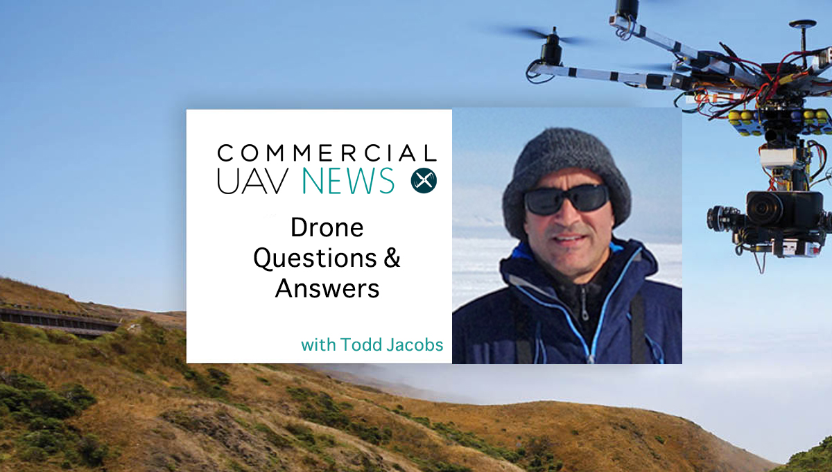
Todd Jacobs is from the National Oceanic and Atmospheric Administration (NOAA), and he’s set to attend the Expo as a
UAVIP, which takes place October 31
st – November 2
nd at the MGM Grand in Las Vegas. He has been with the organization since 1989, and has been involved with NOAA’s UAS program since it began in 2004. He explained that history in our interview, which ran a bit more than my standard five questions, but I couldn’t stop myself from further exploring a few of the things he mentioned.
Tell us a little bit about your history with UAVs in the capacity of your role with NOAA. How have you and are you using drones?Todd Jacobs: In late 2004 I got selected to be part of a team of folks representing various offices in NOAA, which is an agency composed of several sub-agencies like the National Weather Service and the National Marine Fisheries Service. I work for the National Ocean Service, which does things like chart the oceans and manage coastal zones and National Marine Sanctuaries.
I was picked to be one of the representatives for a project that we were collaborating on with NASA and General Atomics. It was around putting a NOAA payload on Altair, which was a pre-production Predator B with a special high altitude wingset. We developed a payload that was representative of many of the types of missions that NOAA would fly on a persistent, medium-high altitude long endurance platform. I came to specialize in using small unmanned aircraft to access remote and hostile environments, either from the shore or ships, to form various marine monitoring strategies. That included marine mammal and seabird surveys, oil spill quantification and tactical support for disasters, plus a lot more.
What kinds of things have you been focused on as the support for these uses has expanded?In November of 2014 there was a big meeting for the UAS program and Sandy MacDonald, who was the first visionary of UAS in NOAA, challenged us to work on implementing UAS into data gathering to respond to environment events, be it a tsunami, oil spill, volcano or anything else. It was a simple challenge, but to implement that, there are tons of things you have to do. You have to have your three basics: access to equipment, qualified, current and competent operators and access to the airspace and frequencies for command and control and data links.
It tied into what I wanted to focus on with the technology, because I'm after the big gains with UAS. Those gains are coming in remote and hazardous locations where you don't want to put people. Drones can also make a huge difference in terms of being able to react and respond to things in near-real time. It's about spontaneity. I'm trying to drive down what is usually months of advance prep for working on securing airspace and getting the crew scheduled, getting the equipment tested and shipped, deploying the equipment, dealing with weather, etc. It's something that is time consuming to get results.
So much of it is about being able to get down from months or weeks to hours. That's been my focus.
Have you been able to make that happen?In May of 2015, I got a couple phone calls that let me know there was an oil spill off of Santa Barbara. My office is in Santa Barbara, so I knew we had access to Puma AE UAS equipment, including advanced payloads (high resolution Nadir mapping cameras in this case) and operators through our CRADA (Cooperative Research and Development Agreement) with AeroVironment that supported half a dozen oil spill drill scenarios. We had already provided support to oil spill drills in the Santa Barbara Channel and in the Arctic with AeroVironment’s Pumas, streamed data into incident command centers, etc. It was right in our lap.
NOAA’s HAZMAT group then called to say they wanted to see if they could officially test the Pumas by tasking them through the incident command structure to support damage assessment work. That's documenting how much oil is out there and the effects of the oil on the nearshore environment. We also got in touch with AeroVironment and they said they would send us their best team and all the gear we needed.
I got hold of my boss, the director of the UAS Program, and I told her that this was it. I told her that I needed NOAA’s Aircraft Operations Center to work with the FAA to get an emergency COA or TFR, that I needed them to authorize these flights under NOAA, and challenged them to go through the paperwork that they wanted 110 days to review in 110 minutes. We had already done this exact thing several times, but now it was real.
It took two whole days for all those pieces to come in place, but we set a precedent. We were the first unmanned aircraft operation to be legitimately tasked through an incident command to not only support data collection during an oil spill response, but we coordinated and flew in conjunction with two manned helicopters. We were flying, talking all day and coordinating flight plans. That had never been done before. We mapped that whole oil spill and demonstrated mapping the main spill area at Refugio Bay at 1½ cm per pixel, so we’re talking about super high-resolution mapping.
These are the sorts of assets we can create and utilize in the short-term and long-term, which is very powerful. I'm trying to work on the optimization of equipment and imaging resolutions to enable integration into not only the NAS but into operations everywhere, even in places like hurricanes.
NOAA wants to fly into hurricanes with drones?The way hurricane missions have been quantified traditionally is that we have two WP-3D Orion Hurricane Hunters, and those are big, heavy aircraft. The P-3 penetrates the eyewall of the hurricane and flies in the eye while it's dropping these data packages called dropsonds. They send back info about wind velocity, direction, humidity, temperature, etc. to the airplane for as long as they're functional. The Air Force does hurricane quantification using C-130s which are similar, but they do not penetrate the eyewall.
There was an event a number of years ago where one of our P-3's was in such a precarious position after having an engine flame out while flying in the eye of a Hurricane Hugo, that the crew was putting on their survival suits and getting ready to ditch the plane. But, they were able to get out of it and get back. That was a watershed event and got the agency to begin thinking about different approaches.
NOAA’s Aircraft Operations Center, UAS Program and the National Weather Service are comparing and considering how we can someday possibly avoid sending people into hurricanes by using UAS technology. In conjunction with NASA, we can fly a Global Hawk persistently above and around hurricanes all day and half the night. Working with NCAR (US National Center for Atmospheric Research), we've developed a new payload system that can get dropped from the Global Hawk. The UAS can fly over 13,000 miles and stay aloft for over 30 hours. The spatial extent and resolution of data is amazing.
Flying into the eye of a hurricane strikes me as the definition of dangerous, but such obvious hazards aren’t the only precarious positions your people find themselves in, are they?I've spent a lot of time at sea working with mature systems that you can launch and recover from ships, given that that's how we get to the most remote places we go to. The most dangerous thing that wildlife biologists do is flying in airplanes for surveys. That's how more wildlife biologists are killed every year. It's a huge issue because they're flying off of cliff faces in helicopters, in remote areas with little to no redundancy or way off-shore, in arctic conditions. It's a very dangerous pursuit.
How are you able to mitigate dangers to those people and the environments themselves with UAVs? Two summers ago I managed a big project where I was out in Hawaii for about 11 weeks straight. We collaborated with NASA on the first remote deployment of Ikhana, their MQ-9 Predator B from Barking Sands Kauai, and we flew Puma AE from the NOAA Ship Hi'ialakai in support of the annual Hawaiian Monk Seal Surveys in the the Papahānaumokuākea Marine National Monument (Northwest Hawaiian archipelago). We were also testing the Puma system for its ability to help locate lost fishing nets that get entangled in the reefs so they can be removed when possible.
The way the monk seals are traditionally surveyed is by a landing party of biologists ashore from the ship via small boat. They get on a skiff, which is lowered to the water from about 40 above. Around six biologists are on this thing, which then needs to time the surf and burn it through shore break to drive them right up on the beach. The people that hop out are required to wearbrand new clothes with tags that have been in the deep freeze for at least 72 hours, so that there's no chance of introducing any exotic organism or seed into these pristine environments.
To the extent that we can do these surveys with a UAS, we can operate from the main ship itself and not have to put that team ashore on a skiff. That allows us to eliminate the risk of a landing party because we don't have to send the scientists through the surf a thousand miles away from medical facilities. We don't have to risk introducing exotic organisms to these environments. Plus it's faster and is less disturbing to the animals being surveyed.
We're augmenting and also changing our approach because of these capabilities.
Wrapping things up, you’re set to attend the Commercial UAV Expo, which will be taking place on October 31st and running through November 2nd in Las Vegas. What are you hoping to see and experience at the event?I'll be on the lookout for some technology to support streaming high-resolution full motion video when around flying beyond visual line of sight (BVLOS). In Antarctica, we flew Puma 25 miles from the icebreaker to support the coast guard activities. Flying BVLOS is going to be the next major advance as we move toward spontaneity to operate small UAS for data collection, emergency response, law enforcement, etc.
I've also always got my eyes out for waterproof VTOL UAS with a decent range that we can operate reliably from ships. After 30 years of going out to sea with scientific gear, I can tell you that everything eventually ends up in the water. My take on operating UAS in general from the sea is that they either have to be designed to be waterproof or they have to be priced at a point that they're expendable. Because no matter what you do, it's going to end up in the water. That's something I'll be looking for because it's a hole in our inventory.
Do you qualify for a UAVIP free conference pass? Find out here, or simply register for the Commercial UAV Expo 


Comments