

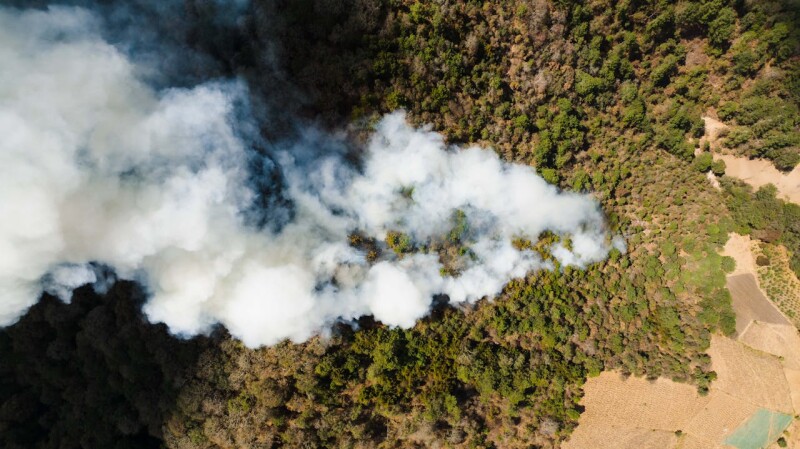
From tracking wildfires to surveying previously unreachable landscapes, drones have fundamentally transformed the way emergency response professionals operate before, during, and after natural disasters. However, a recent article exploring the difference that real-time location data can make highlights how much further value can be created when it comes to saving lives and keeping teams out of danger.
Mike Cox is the Director of Fire and EMS Solutions at Esri and he’s been working with emergency response teams of all shapes and sizes to adopt new tools and technology that better enable their efforts. Those efforts led to many lessons learned from the search and rescue response to Hurricane Ian in 2022 as well as how the Search and Rescue Common Operating Platform (SARCOP) has transformed hurricane response with real-time tracking. Drones have also been utilized to enhance the safety of first responders during wildfire response and at music festivals, showcasing the many different ways the technology is making a difference to first responders and the general public.
What does it mean to utilize drone technology to not only avoid the duplication of efforts but also reduce risk to safety personnel? Does real-time mapping enable tangible advantages during emergencies? What's the best way to integrate these new tools? Answers to these questions should define the approach to adoption and integration that makes sense to individual teams and for entire agencies.
Understanding the “Holy Grail” of Public Safety
SARCOP is a multiagency platform designed to share information and intelligence throughout all levels of incident response. That goes from first responders in the field to decision-makers in the Emergency Operations Center. The program has been running successfully since 2017 but a streamlined approach was defined in 2020 with the creation of the National Search and Rescue Geospatial Coordination (NSARGC) Group. Today, the platform provides a shared operational view that enhances coordination to better support thorough search efforts.
That kind of shared operational view is essential to effective response efforts, especially when multiple agencies at local, state, and federal levels are involved. Coordination plays a crucial role in executing an initial risk assessment, which is the foundational step of any incident response. Without a shared operational view, response effectiveness can be limited, and it’s easy to understand why.
“Think about a fire engine pulling up to a house and just seeing smoke coming out of it,” Cox said. “That team doesn’t know where the fire is, or if anyone’s inside, or how long it’s been burning. It’s the same for a large-scale event. The search for life is the first priority, and if verified data can inform the decisions I make as part of that process, then maybe I don't send somebody into a hot zone to get that information. If I’m getting that insight through remote sensing and GIS, I’m making a decision that not only keeps that person out of harm’s way but also allows me to use that person in a way we know will benefit the overall response.”
Cox explained that same type of initial risk assessment is what personnel from the Federal Emergency Management Agency (FEMA) will do when they show up. Where should they concentrate their efforts? Who needs to be deployed where? By leveraging drone-collected data and other SARCOPS tools, emergency responders can avoid duplicating efforts and achieve better collaboration with local authorities, including law enforcement and even utilities, frequently needed during disasters.
It's impossible to overstate the importance of not unnecessarily sending resources into something like a hot zone though. When search teams operate with the same reliable data, they can more accurately assess the probability and possibility of rescue, which is significant at every stage of the response effort.
“Keeping teams out of those situations is something that came up when we had significant flooding in Kentucky a few years ago,” Cox told Commercial UAV News. “Using SARCOP, they could see there were areas that were 20 or 30 feet under water, so those areas could be eliminated from our rapid search efforts. It makes a huge difference to be able to identify those kinds of hazards in your decision-making process. That allows us to focus on something we can deal with right now, as opposed to having a team go out just to find out there’s nothing they can do.”
That kind of active decision-making is also positively impacted by passive efforts of personnel that are using the technology. ArcGIS Field Maps from Esri allow teams to not only know where a mobile workforce is in real-time but also see and understand where they've been. The technology is also incredibly easy to use as well, as a firefighter simply needs to pull up the app when doing a search. As they document the area, they’ll leave a breadcrumb trail that enables anyone in the command post to see where they’ve been to confirm what areas have been searched.
At the end of the operational period, using machine learning analysis, that same data can inform whether a given area or structure needs to be more fully examined. Not having to manually go through and verify that information saves an incredible amount of time and resources that can be redeployed more effectively.
Enabling that kind of tracking for public safety resources all day, every day, is something that Cox called the “holy grail” for the industry. If somebody calls for help when inside a structure, the command post wants to be able to send support to a specific location. Without accurate location data in a 3D view, that’s not something they can do. This technology can enable a safer working environment to support someone in need.
The adoption of such tools isn’t just about the technology though, as the people who use them as well as the systems they operate within are even more critical. Successfully using these new tools and technologies to deliver more targeted services that meet community needs requires a clear understanding of what data moves between different teams and departments and how it’s doing so. This understanding can start modestly but quickly expand in both scope and impact.
Adoption, Integration, Collaboration...and Donuts
An incredible example of cross-department collaboration was showcased at the recent Esri Federal GIS conference, which highlighted what it meant for the Government of the District of Columbia Fire and Emergency Medical Services Department to work with the Government of the District of Columbia Office of the Chief Technology Officer. While shared dashboards and workflows made a tangible impact, their approach to collaboration is what truly made the difference. Cox frequently highlights this point when discussing the adoption of tools like ArcGIS or the use of real-time location data, as many teams don't realize what could be easily enabled with better collaboration.
“My biggest issue is that leadership often doesn’t realize that their city, county or state agency is already engaged with GIS,” Cox said. “I've had many a presentation where a fire or police chief will ask me how much a certain piece of software costs, only to come to find out that their utilities department, or their road department, already has it. If you’re engaged with Esri, that means all of the agencies get access, but making all of the stakeholders or even those individual users aware of that fact can be a big challenge.”
Having that awareness can define an entire emergency response operation, as local government agencies are the most in need for technology support and good data for making decisions in the first 12 or 24 hours, long before FEMA or other outside resources are deployed. The ability to perform accurate risk assessments and establish a foundational information base that others can then plug into is the reason so many local agencies have adopted SARCOP, which is now easier than ever.
Recent updates to improve usability have helped spur adoption, as the ease of use of the mobile applications in the field is incredibly important for firefighters and rescuers. With new learning models and AI, search segments can be evenly split up automatically to ensure teams aren't overworked while others aren't underworked. Using an app or QR code, users can be up and running in three clicks.
Recognizing these distinctions is crucial for anyone still using pre-SARCOM methods or systems that rely on info collected during an operational period. During an emergency situation, info gets old fast, which can adversely affect decision-making and processes in the short and long term.
“A team could spend an entire day putting together physical mapping resources that have details like where a rescue victim was found, where structural damage occurred, etc.” Cox explained. “Those kinds of physical assets are then supplied to the task force leader working in the command post at the end of the day. They’ll use that info for further planning, but by the time those decisions are being made, some of that info could be eight hours old. That task force leader is now making decisions on something someone saw in the field that's completely irrelevant. With SARCOP, the task force leader can evaluate info that isn’t eight hours old but eight seconds old.”
That same information can also be utilized after the emergency period ends. Following a hurricane, FEMA might coordinate with over 30 departments and agencies to respond and recover. If individuals and entire agencies can utilize data that’s already been captured, the number of personnel they send out can be reduced, thereby reducing the cost overall.
These kinds of technology details matter, but answers around coordination and collaboration are far more fundamental. That’s why experts like Cox believe the only way to effectively adopt and utilize new tools and technology is to approach such things in a way that’s much more about people than process.
“I would tell a police chief or a firefighter to grab some coffee and donuts and sit down with one of the IT directors that’s outside their department,” Cox said. “Those conversations allow you to get a consensus around priorities and objectives that are bigger than any one team or department, but they also allow you to find out what you actually own. Public safety agencies probably have access through other agencies to software and technology they may not even know about, so go find out. Have those meetings and make those friends, because it’s the best way to tell the public safety story in a way others can really understand and then help you with.”


Comments