

To say the drone market environment is a vast one is a bit of an understatement. Numerous organizations of all types and sizes are working to establish themselves in one way or another in the marketplace, but some have been doing so for a lot longer than others. Lehmann Aviation has been developing and manufacturing ultra-rugged and cost-effective professional drones since 2005, and with the announcement of their brand-new L-A Series, they aren’t showing any signs of slowing down.
You can read more about that announcement via the press release below, but I was able to connect with Lehmann Aviation Founder and CEO Benjamin Lehmann to explore this announcement in a bit more detail. He laid out some further info about how these products can make an impact for individual operators and organizations as a whole. Jeremiah Karpowicz: Your company just announced the release of the L-A Series, which is comprised of three fully automatic aircraft for three major mapping applications. How do you feel these products differentiate themselves from your competitors?Benjamin Lehmann: First of all, at Lehmann Aviation we design professional drones for harsh environments, so our major goal is to make them ultra-rugged, reliable and easy to use. Since 2005 our customers have been flying our aircraft all over the world, at temperatures from -25°c to +60°c (-13°F to 140°F) and tough environment conditions, so our team of engineers has used more than 10 years of operational experience to design our new L- A Series.Our goal is to give our customers the best R.O.I. they can find on the market. We design and manufacture durable professional tools that can serve our clients long-time, and it is very important for us that our customers feel the right value for each our product, and also feel ensured to win money quickly with them. Each of the models in the series are geared toward a different type of professional: the LA500 is for Mining and Construction, the LA500-AG is for Precision Agriculture and the LA500-RTK is for highly accurate Mapping and DEM. What sort of specific results will professionals in these industries see on account of using these products that are specifically designed for their industry?All our L-A Series is based on the same platform, but each model has specific functions and hardware in order to facilitate day-to-day operations for each type of application.LA500 is done for general mapping purposes, and is our entry level model for mining and construction. Thanks to different cameras options (thermal, RGB, NIR …), with up to 24.3Mp resolution cameras, LA500 is a versatile aircraft that can make multiple measurements faster and at lower costs.LA500-AG comes with a specific multispectral camera already installed to allow our customers to manage their crops ultra-efficiently, much faster and at lower cost than any ground survey. They will be able to Create a reflectance map of their crop and count plants; Detect drought, erosion, pests and plant disease at early stage; as well as Adjust the exact amount of fertilizer and water they really need.LA500-RTK is for those who need the most precise data. This version will enable them to save hundreds of labour hours by making high precision DEM in just few minutes, without the need of any GCP (ground control point). Why is it significant that owners will be able to replace or upgrade any part of the drone if needed without changing the whole system?In our world where technology is evolving so fast, we want our customers to be satisfied on a long term basis. For this reason we will propose them to upgrade their material on a regular basis, in order to always get the best and up-to-date tool they need in the field.Also, our new modular design enables lower costs of operations and maintenance, as it provides easy parts replacement, with no obligation to shipping the system back. Each operation can be done easily and quickly, right in the field. Since all of these aircraft are programmed and controlled through the brand-new version of OperationCenter software, would you consider them a “complete drone solution”? Our UAS are data acquisition systems. With OperationCenter v2, our customers will be able to operate all our aircraft, L-A Series, L-M Series and upcoming models, in accordance with their mission needs.So they are complete drone solutions. But even if most of our competitors do, we are not pushing specific post processing software, as there are many tools on the market now, and we let them choose what is best for their specific needs, in accordance with their budget and professional preferences.
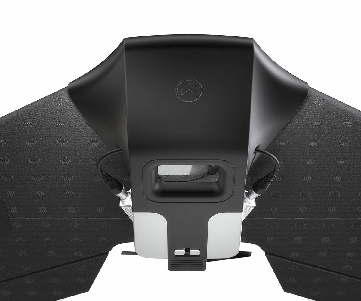
 Lehmann Aviation redefines mapping drones with the brand-new L-A SeriesLehmann Aviation (www.lehmannaviation.com) announced launch of a totally new L-A Series line of professional mapping drones for operators around the world. Lehmann Aviation also shared new features from the all new OperationCenter v2, the most advanced Drone Management System.The new ground-breaking L-A Series is comprised of three fully automatic aircraft for three major mapping applications: LA500 for Mining and Construction, LA500-AG for Precision Agriculture and LA500-RTK for highly accurate Mapping and DEM. Modular by design, L-A Series redefines mapping dronesThe new L-A series was totally redesigned from scratch, putting together 10 years of operational experience and customers suggestions, from all around the world. Made of aluminium, carbon fibre and EPP foam, with a new unique modular design and new powerful autopilot, the systems are even more rugged, reliable and easier to use than previous aircraft, at the same ultra-competitive and unmatched prices on the market.Now totally modular by design, which enables to replace or upgrade any part of the drone if needed without changing the whole system, the new L-A Series will provide the best R.O.I. to its owners, now and in the future. Coming with detachable winglets while keeping the same small weight of less than 1250gr/44oz (maximum, including the camera), the drones are also much more compact and easy to transport.All the aircraft are programmed and controlled through the brand-new version of OperationCenter software for Windows 10. OperationCenter v2, with a lot of new features and a powerful integrated User Interface, is the world’s most advanced control software for fixed wing drones. Achieve your mapping goals with one single systemThe new aircraft, working with Sony α6000 (24.3Mp on a large APS-C sensor), multispectral Sequoia (LA500-AG only), thermal Flir View Pro, or even a simple GoPro Hero4 cameras, enable to take images at up to 25km/15.5miles range and 45 minutes flight time. Hand-launched drones fly and land autonomously in just few meters, even on rough surfaces.The launching prices - a limited time offer - of the new L-A series aircraft are as follows (ready to fly aircraft including Long Range Data Modem):
- LA500: USD3,490 / 3,490€* (camera not included)
- LA500-RTK: USD5,890 / 5,890€* (camera not included)
- LA500-AG: USD7,990 / 7,990€* (including Sequoia camera)


Comments