Flight time and weather conditions are often cited as two of the most challenging logistical issues that drone operators deal with, but that might not be the case for much longer. Advances to battery technology are changing the paradigm around how long drones can be expected to stay in the air, while the creation of drone weather risk management frameworks like ones from TruWeather Solutions have proven to keep UAVs flying 40 percent more of the time when weather uncertainty is a factor. Recovering lost profits for weather sensitive businesses is just the beginning of the value these types of tools can open up though.
TruWeather is a weather data and analytics company founded in 2015. Founder Don Berchoff was a twenty-four-year Air Force veteran and former National Weather Service Director for Science and Technology, which enabled him to form an incredible understanding around weather challenges, since the Air Force has been flying drones for over 20 years. In 2001, US Air Force financial analysts validated that framework when they were able to use it to cut aviation weather delays from 5,000 to 1,800 in one year, recovering over $200 M, illustrating the potential value of weather data. Their TruFliteUAS™ system is designed to meet the needs of several drone industry segments.
We connected with Berchoff to get a better sense of what it can mean for commercial drone operators to similarly create value with weather data, which can mean everything from improving the protection of personnel and equipment to reducing liability to improving operational results. We discussed TruWeather’s deep aviation and weather pedigree, what makes the info his solution provides distinct from the info anyone can find on a weather app, what he’ll be showcasing with the product at the upcoming
Commercial UAV Expo and much more.
Jeremiah Karpowicz: Why do you think the UAS industry need better weather data?Don Berchoff: Drones by their very nature are very weather vulnerable. Seemingly benign wind, turbulence, icing, precipitation, fog, and clouds to larger aircraft can significantly impact the stability control and travel distance of drones due to their light weight and design, and reliance on batteries. The current aviation weather system was designed for where manned aircraft fly, in well weather-instrumented cylinders of airspace around airports. Drones will operate nearly everywhere, and there are significant weather data reporting gaps away from airports, especially below 1,000 ft in the near-Earth zone. This zone has terrain that impacts wind speed and direction and daytime heating causes gusty winds, turbulence and large temperature contrasts between cities and rural areas that drains battery usage and shortens travel distance. Having very granular understanding of micro-climates in real time will enhance safe and profitable operations.
Isn’t the information that operators can get from their Weather App, TV Station, or the National Weather Service good enough? The public weather services most users are familiar with from TV stations, applications, or National Weather Service are perfect for general weather knowledge. But just as the military and airlines cannot rely on public weather services for mission critical operations, neither can drone operators. Drones, especially when they begin flying beyond visual line of sight at five, ten or fifteen miles from the takeoff location, will require micro-weather data with more granularity and customization to reduce accident and liability risk.
For example, a forecast of 30% chance of showers and thunderstorms on a specific day can cover an area of 15-20 counties. It doesn’t specifically tell when and where the rain will fall. The uncertainty of such a forecast either causes an operator to fly without a clear understanding of the risk, or causes a conservative approach, that may unnecessarily ground the drone, preventing it from producing important revenue and reducing profitability.
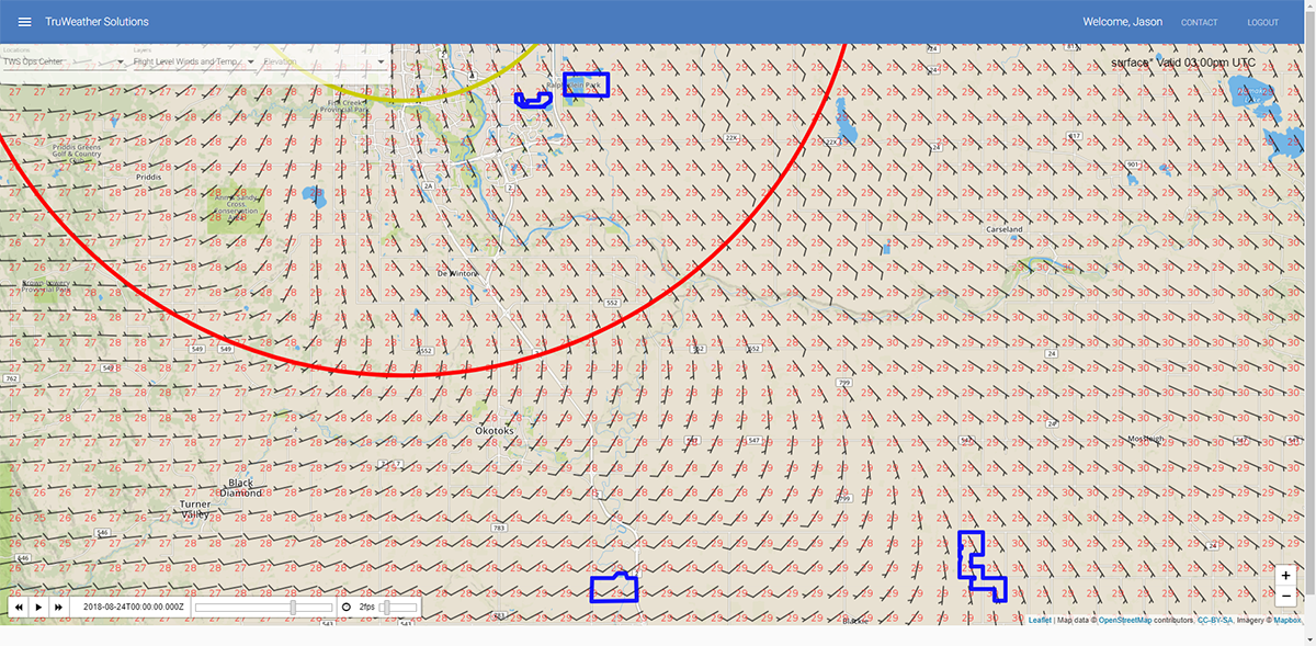
TruWeather's 100-meter resolution wind forecast supporting BVLOS Pilot Project in Alberta, Canada
TruWeather will drive down weather uncertainty by a fusion internet-of-things data collection and micro-weather detection systems, producing very precise weather predictions for where drones fly using computer acceleration technology and generating machine learning algorithms that will translate weather data for the operator into simply flight path go/no go indicators. TruWeather will detect fine scale weather, for example, how a nearby hilltop affects the winds coming down the valley, or how the nearby lake may affect temperatures that impact icing or battery life.
As society and businesses become more dependent on drones and scheduled services, TruFliteUAS™, will provide “weather for drones” and generate 40% more drone fleet flight time when weather is a factor.
How have you seen tasks or even entire projects impacted by stakeholders who don’t actively consider the weather?TruWeather does not have insight into stakeholders who do not actively consider weather as we are only focused on those who understand the benefits and leverage our services.
For example, TruWeather is currently supporting the NUAIR Alliance and NASA test missions flying at Griffiss Air Force Base. TruWeather’s precise weather data and real-time integration in decision-making saved time and money, while advising officials on how various weather events would impact operations. TruWeather followed general weather forecasts and those forecasts did not provide enough fidelity on local fog and showers that impacted several test periods. TruWeather’s risk assessments enabled rescheduling of flight times to optimize good weather periods and avoided deploying costly assets during bad weather periods. The pinpoint forecasts optimized resources and enabled several tests to finish on time with all objectives met.
Similar results occurred when TruWeather assisted Quantifly, one of our fellow GENIUS NY 2018 companies. TruWeather provided targeted weather data to conduct a traffic and parking study for the city of Detroit. Drone platform specific wind predictions were provided from 0-500 ft for every hour from 7 am to 7 pm, which included a high-risk period between 3-5 pm for developing thunderstorms. Quantify prepared accordingly and at 2:50 pm TruWeather issued an alert, allowing the drone to safety land and avoid the threat. Forty minutes later, the drone was relaunched, the mission completed, and the drone available for a new job the following day.
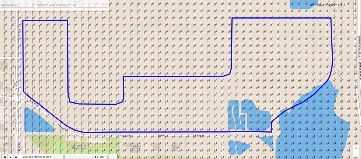
As you zoom in, notice the increased density and granularity of data.
For business, better weather data will provide more confidence in decision-making. “Can I fly right now and complete my mission?”, “Can I schedule operations tomorrow?” and “Do I have a system in place to be aware of and notified of weather threats while my drone is in flight?” TruFliteUAS™ answers these questions and allow our users to focus on the mission at hand, satisfy their customers, and maximize flight time, and more importantly profits. TruFliteUAS™ will increase flight time by 40 percent when weather uncertainty is a factor, resulting in more productivity and revenue generation.
For consumer and regulators, the primary concern is safety. Weather is a primary risk to drone safety. Drone operators cannot engineer weather out of the equation, but precise weather data and awareness, coupled with a disciplined risk management and decision system will reduce the threat. TruFliteUAS™ we will enable consumers and regulators to safely use this technology for the benefits of communities and mitigate the risk of weather threats so that pilots and companies can safely and reliably operate in communities.
What sort of info and insights are you hoping to share with Commercial UAV Expo attendees?TruWeather Solution’s main goal at the Commercial UAV expo is to educate users on what is possible. Weather happens, but good data, planning and decisions can result in safer, more productive operations. TruWeather seeks to narrow the gap of uncertainty and help our clients achieve more flight time, greater reliability, and a greater ROI. We believe that by educating users we can show a path to successful UAV integration into the National Air Space and help to be an economic engine for any aspiring UAV business or program.
If I’m a commercial operator that thinks any headaches or additional costs related to weather are just part of life or the price of doing business, what would you tell me?The cost of weather was $534B in 2014. Through accredited studies, up to 40 percent of these costs are recoverable. Weather costs U.S. airlines over $3B a year.
Drones will have similar weather impacts, and without a systematic approach to mitigation, it will cost businesses money that is recoverable. Even on a perfectly clear day, winds on the ground may seem acceptable, but at 200-300 ft elevation, they could cause unexpected battery use, requiring mission termination at a cost of several hundred, or thousands of dollars.
TruFliteUAS™ is designed to identify these risks, make operators aware of them, and enable a better business decision to save time or money. We can’t stop the weather, but we can empower our TruWeather clients to mitigate the weather.
To learn more about TruWeather, make sure you stop by booth #109 at the upcoming Commercial UAV Expo, happening October 1-3 in Las Vegas. 


.jpg.small.400x400.jpg)


Comments