


Being able to use drones to perform established tasks in faster, cheaper, and safer ways has always been a top priority for organizations of all types, with state agencies specifically taking advantage of the opportunities the technology represents. Whether it’s measuring the success of a drone program or quantifying exactly how much money is saved when using drones, stakeholders have been able to calculate the value the technology unlocks when compared to their traditional approaches.
Those traditional approaches are often related to an inspection or data gathering process, but there’s so much more to the tasks that the Alaska Department of Transportation & Public Facilities (DOT&PF) is responsible for on account of their avalanche mitigation efforts. A recent news report highlighted the difference it made when drones were used to drop two explosives from UAS a first for the USA. It showcased exactly how drones can be used to enhance safety and efficiency in the department’s avalanche mitigation efforts.
This recent work is built upon efforts that go much further back, highlighting the commitment it takes to enable success. Doing so can make a difference in multiple ways though, with enhancements in safety and efficiency that others can learn from as they work to integrate drone technology.
 The Process of Drone Integration
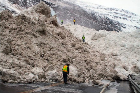
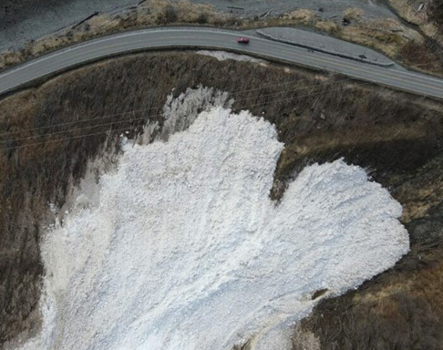
The goal of DOT&PF Snow Avalanche Program is to improve safety for highway users while also minimizing avalanche related traffic delays and road closures. As part of these efforts, crews use military artillery to artificially trigger avalanches that are smaller to prevent larger, unmitigated avalanches from coming down and impacting open roadways. The department’s use of explosives in this manner is not unique, as others in the region use similar methods, while the practice itself goes all the way back to the 1870s.
Much more recent is the work by the US Department of Transportation and Washington State Department of Transportation in the early 2000s, which demonstrated the feasibility of using a heavy lift UAS platform to drop a single explosive round for avalanche control. The DOT&PF utilized insights from these efforts as part of their recent test of two different drone systems with various types of payloads, which included standard (non-military) civilian avalanche explosives.
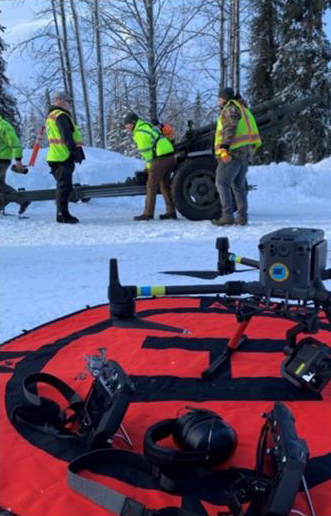
Artillery has been utilized in Alaska in this manner since the 1950s, but the team currently has multiple pieces of equipment on lease from the US Army in Alaska. A stipulation with those leases, which also include training that is strictly observed and required, has made the department’s exploration of drone technology even more of a priority.
“As part of our contract with the Army, we’re actually mandated to stop using artillery pieces of equipment when commercially viable alternatives are on the market,” said Timothy Glassett, DOT&PF Avalanche and Artillery Program Manager. “We’re focused on exploring these options as they’re available in order to fulfill that commitment while also keeping our team and the public that much safer.”
As a quick illustration of what that commitment meant just to be able to conduct this test, the DOT&PF got permission from the FAA, which thoroughly evaluated the proposal to utilize UAS equipped with an explosive device to trigger the avalanches. [GTD(1] Additionally, the Alaska Railroad Corporation needed to provide approval, since the testing was being conducted along RR infrastructure. There were also requirements for pilots within both of those organizations, the land managers, the Forest Service, the ATF and even local fire departments and law enforcement. But all of that came after sorting out the technology piece.
 This test was ultimately done to explore an alternative to Remote Avalanche Control Systems (RACS). These large, stationery boxes are standard for avalanche hazard reduction. A drone was outfitted with Drone Amplified’s DART system. It is an in-development system for this application. Drone Amplified was chosen because of its IGNIS fire management system, which in the eyes of the FAA, is very similar to explosives or flying with hazardous material and deploying it from the air. Drone Amplified has experience with this exact type of application.
"Essentially, these are flaming balls that get dropped from the sky,” Glassett told Commercial UAV News. “They had been used as part of wildfire efforts to decrease the development of large, destructive wildfires. They already had that authorization from the FAA to drop flammable material from UAS, so we were able to work with the FAA to get an authorization within a year, which was quite a bit faster for this kind of explosive work.”
Glassett mentioned that Drone Amplified’s solution wasn’t the only one they tested, but theirs was the only one that met the DOT&PF team’s flight requirements for distance and the overall safety of the system as a whole. That technology piece along with Drone Amplified’s experience working with complex UAS systems allowed the DOT&PF team to more quickly showcase how drones could enhance safety and efficiency. They’re specifics that can now be quantified and built upon by DOT&PF.
Just as critically though, these lessons define a blueprint for others interested in deploying drone technology for these sorts of applications and beyond.
 “Augmenting What We Need to Do”
Like any integration process for a new piece of technology, Glassett mentioned how the department’s work to define the efficiency and feasibility of drones needed to be connected with the economics. The RACS there planning on using to trigger an avalanche cost well into the six figures, and each is for the most part only good for one location. That’s in contrast to UAS that can practically go anywhere at what might be one quarter of the cost.
That said, drones aren’t viewed as a full-on replacement for RACS, but to instead fill in the gaps and complement their overall avalanche mitigation efforts, many of which go beyond RACS. Looking at the adoption of any new tool in this way is all part of a wider transformation for the department.
“While we’re looking to move away from relying on artillery, we know that UAS isn't going to replace what an artillery piece can do, for multiple reasons,” Glassett said. “UAS is limited by size and range, and right now, we’re only authorized to use the technology at this one specific location that is quite isolated. But as we prove the capabilities, our goal is to get authorization to use it in other locations and fully define where it can augment what we need to do in a way that makes sense.”
Less artillery missions means a redistribution of team resources, as there are set requirements of support for any artillery mission. Fewer teams in the field to provide that support also decreases exposure to risk and increase the time that those teams can get back to maintaining the highways. The safety difference between flying with explosives on a helicopter versus putting them on a drone is significant.
Those risks are especially prevalent in ski areas, where teams are going out on skis to either toss explosives or place them. Some of those are steep avalanche prone areas, which means a drone could be used instead of a human. All of that ties into where Glassett sees the most opportunity and potential.
“I strongly believe there is a space within avalanche mitigation for UAS work,” Glassett mentioned. “Outside of UAS mitigation testing, we're using UAS for all kinds of different other things, from mapping to emergency response. On the mitigation side though, it really is a blueprint for every other railroad program or for any transportation corridor or ski area to be able to use drones in places you can’t safely get to on skis or where one of the RACS doesn’t have you covered.”
That blueprint is one other states interested in deploying drone technology for avalanche mitigation can now utilize, but the potential to use this model goes beyond avalanche applications. The permissions and technology challenges that DOT&PF had to sort out are no small feat, and for many other departments, such challenges would not be nearly as intense. Nonetheless, sorting out where to begin can be a daunting task, which is why Glassett’s advice is to start small.
“Just flying a UAS for imagery is the most basic thing you can do but there's an incredible amount of value you can get just from doing that,” Glassett said. “You can easily deploy a UAS with thermal capability to more effectively search an area and save time. And once you get that down, you have a baseline for longer term planning that can include mitigation efforts. Right now, most people are just using UAS to take pictures, and that’s a great place to start. But it’s also just barely scraping the surface of what UAS can do.”


Comments