


The drone industry is waking-up. UAV systems are flying off the shelves, sensors are being identified to help us visualize an increasing range of phenomena, and end-user applications are being identified in every industry imaginable, but none of that is as important as the shift that was on display at the Commercial UAV Expo. The transition to focus on the data these devices are gathering, rather than the devices themselves, is both significant and necessary
In his keynote at Commercial UAV Expo Americas, Intel’s Anil Nanduri again emphasized how ‘data is the new oil, and drones are the new wells’. It was very noticeable how conversations have moved from the form and function of UAV sensors, to trying to work out what to do with all the data that they collect. Ultimately, that's the endeavor that needs to be utilized to justify the investment in the system.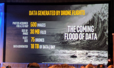
Data floods
Data is heavy. It has overheads associated with it that are far greater than the UAV platforms that are used to capture it. Firms like Intel that are focused on information technology and processing have always been savvy to this.That's part of the reason why the theme that this industry is ‘not a drone market, but an information market’ was front and center throughout the event.The UAV industry has rushed to deploy drone collection platforms in so many contexts. It’s a community that has been fascinated with the feasibility of whether a drone can be used, how it can be flown, and what previously impossible business case it can make. However, what seems to be an afterthought for many is the realization of the magnitude of the volumes of data being collected, requirements of security, processing and access overheads. The need to do something with that data right now (also known as turning it into ‘actionable information’), is a topic that many presentations focused on.Storage, security and the cloud
Few of these themes are new. They’re topics that we’ve discussed at length in the past, especially in the context of data transfer and the speed at which return on investment (ROI) can be achieved for a drone operation. However, the nuance and detail with which these topics are now being discussed is an exciting development.UAV use has been increasing across the enterprise, and that’s why it was interesting to see an increase in the discussions about security in the Q&A sessions for industries such as mining. There are industries where data transfer and storage strategies via UAVs have been dealt with in a relatively piecemeal manner. Highly regulated industries have always needed to work in the context of secure file transfer protocols and policies that require planning in their use.Cloud-based solutions for sharing data and generating deliverables were prominent, and various organizations recognized how and why such things would be important. Companies like Airware and Drone Deploy had foresight in terms of creating solutions for generating specific market deliverables from UAV photographic data for sectors such as mining and insurance. That said, it seems everyone has a ‘cloud solution’ of some type.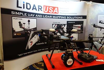 To name three examples from the show, there was the new cloud-based geographic/mapping oriented platform, 4D Mapper, and they believe that they have strengths in the UAV inspection market. Bentley’s ContextCapture now offers a cloud-processing engine that enables the streaming of its reality mesh deliverables via its ProjectWise ContextShare enterprise platform. Lastly, LiDARUSA has recognized the challenges that operators of their UAV and mobile mapping systems face when sharing deliverables with onward clients. It’s part of the reason they developed their ‘myPointClouds.com’ service as a means for their clients to upload point clouds from a survey to share via web browser.It’s a theme that extends beyond these companies though. We are also seeing movements towards integration of siloed drone-processes with the generic data management systems of the enterprise, such as SAP database systems as indicated in the Aeryon Lab’s partnership with Black & Veatch. These are integrations that indicate maturity of the UAV community.


Comments