

UAVOS, a developer and manufacturer of security and commercial solutions based on advanced Unmanned Systems, has recently completed a drone-based inspection in the agriculture sector to measure  water content in soil. Combining digital data and UAVOS's customized software has allowed to provide innovative analysis for water management in agriculture and land management. UAVOS's inspection technology offers timely and accurate insights into the dynamics of soil drainage and moisture content which is able to contribute to productivity of land.
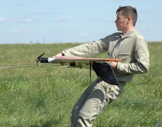
UAVOS’s UAS solution for gathering such soil moisture data is based around its fixed-wing Borey uncrewed aerial system (UAS), and features a multispectral sensor payload designed to provide both spatial and temporal resolution for better understanding of the soil moisture levels. The Borey UAS with a multispectral camera supplies full coverage soil moisture measurements over an area of up to 2,220 acres (9 km²) per flight. The flights have been conducted at low altitude missions of 150 m above ground level. This low altitude is required for the sensor to accurately map soil moisture up to 10 cm/pixel resolution.
The data provided by the Borey UAS equipped with a multispectral camera offers information for the entire area scanned – not just representative samples. Following the drone inspection, UAVOS' mapping professionals provide the client with a detailed report which includes High-definition images and video, Orthomosaic images for import into GIS, Digital surface model (DSM) and digital terrain model (DTM) as well as 3D images to help future crop plantation planning and monitoring growth.


Comments