DJI AirWorks 2018 saw numerous product updates and announcements along with innovative showcases of drone technology, but the news about the partnership between Microsoft and SlantRange caught our eye. Some of that is due to how quickly such announcements can enable tangible results since the initial conversations SlantRange had about the DJI Payload SDK that took place at AirWorks 2017 saw the 3PX announced 4 months later, but this news is about the future just as much as it’s about the present.
The partnership is designed to combine Microsoft’s latest Internet of Things (IoT) connectivity with SlantRange’s edge-computing capabilities, which could lead to the creation of an integrated product offering in agriculture. It’s proof of Microsoft’s dedication to innovation in agriculture technology, which should open up incredible opportunities that involve AI, edge computing, and cloud-based infrastructure.
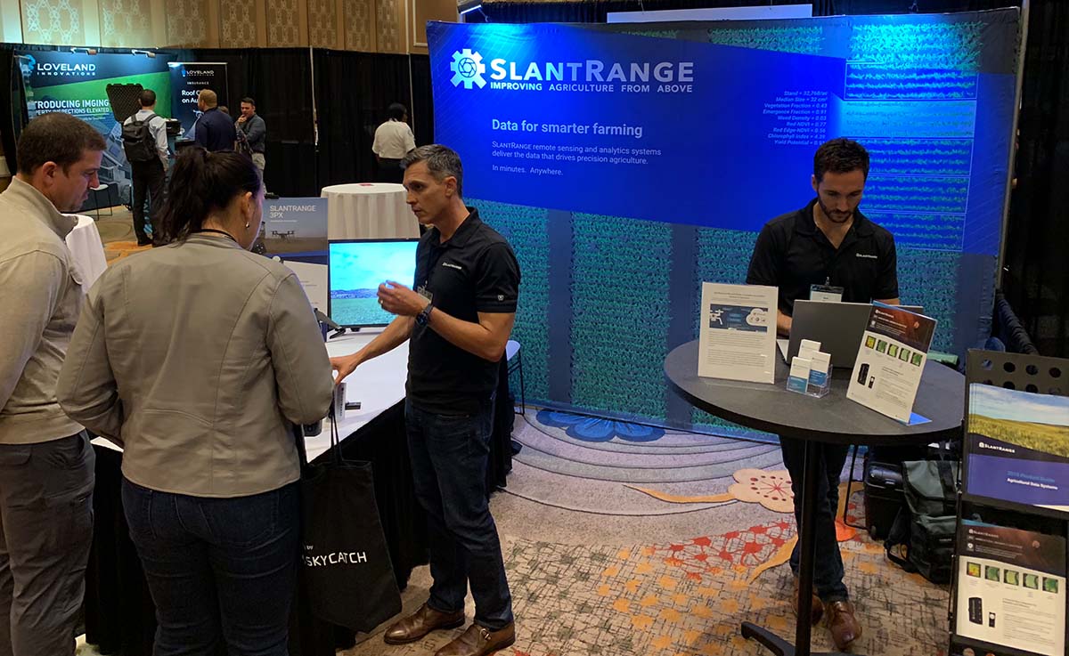
Michael Ritter, CEO of
SlantRange, was at the event to discuss how his company is set to enable these opportunities for anyone operating large-scale drone programs in agriculture, but he had much more to say about how and where SlantRange solutions are making a difference for growers of all types and sizes. He discussed how SlantRange solutions have enabled tangible benefits, and we were able to connect with him to discuss those benefits, the ramifications of the Microsoft partnership and much more.
Jeremiah Karpowicz: One of the biggest struggles for operators of all types in agriculture is working through what it means to transition from “exploring” drone technology to “implementing” it. In what ways have you been able to do that, and how will your partnership with Microsoft make that process even easier? Michael Ritter: This is really the classic question of scale. Time and time again we receive inquiries from people who have either a) tried a low-endurance drone and a simple RGB camera only to find that it doesn’t provide enough value to justify the cost and effort, or b) tried a more capable system but as soon as they attempt to scale their operations, they realize that the data management and data processing becomes a major bottleneck, both in terms of time and more importantly cost.
Our data collection methods and edge-compute data processing engine were developed specifically for agriculture and allow our customers to scale much more efficiently. Not only do our analytics run completely offline, but our low overlap data collection methods and front-end spectral filtering enables our processing to be extremely efficient, with a typical processing time of around 10 minutes for a 100-acre field. And perhaps more importantly, our software plans support unlimited processing, with no per acre charges. With a cloud-based processing solution, the more data you upload and process, the more you will pay for that service.
We’re also developing new solutions to support the implementation of our technology at the enterprise scale. We’ve recently partnered with Microsoft to integrate their Azure IoT Edge technology stack into our product offering. This will provide enterprise users with a full suite of secure tools for large-scale implementation, such as device management and configuration, deployment of new analytics algorithms, distribution of Artificial Intelligence and Machine Learning models between the edge and the cloud, as well as cloud-based data aggregation and analytics.
Are these solutions the essence of what makes your products distinct and different from some of the other options that are available? There are three key areas we focus on when describing the value of our solutions and how they’re differentiated in the market.
First, is the accuracy of our sensor technology. The value of the data we provide is driven by the accuracy of the measurements we collect with our sensors. The best example of this is our radiometric calibration technique, or more simply, the method by which we account for changing sunlight conditions. We now have 3 issued
patents on this foundational technology which, in short, allows you to compare data sets over time to unlock the long-term value of the data we provide.
Second, is the efficiency and scalability of our analytics workflow, provided by our edge-compute processing architecture I discussed above.
Third, and perhaps most important, is the value of the data products we provide. The imagery from a calibrated low-altitude multispectral sensor supports the generation of some very unique and high-value data products that simply aren’t possible from other imaging solutions, such as manned aircraft or satellites. Plant counts, plant size distributions, and separating plant populations from weed populations are just a few examples.
We also provide some customized solutions specifically for agricultural researchers. Our
Aerial Phenotyping service provides this same set of high-value data products but measures and tracks them for each and every test plot of a field trial across a full growing season. We are currently providing these services for large enterprise clients, including BASF, Bayer, Land O’Lakes, and AgReliant and will be expanding the service next season.
Our commitment to data security is another area of differentiation for SlantRange. As part of our partnership with Microsoft, we are in the process of implementing Azure Sphere as the core for our hardware and analytics solutions. Azure Sphere is an integrated hardware, software, and services suite that provides Microsoft’s latest enterprise-grade security for IoT devices, both at the edge and in the cloud. With the growing concern over data security in connected devices and precision agriculture, which was recently highlighted in the Department of Homeland Security’s report titled “
Threats to Precision Agriculture”, we see our edge-compute model implemented on Azure Sphere as an ideal solution to provide this valuable data in an extremely secure fashion. In cases where you may not be able to ensure the data security of the drone, this solution would provide an encapsulated secure payload, completely independent from the drone.
Are the challenges with the integration of these new tools typically related to the technology itself, or to people’s aversion to change? How do you approach overcoming either?It’s definitely a combination of both. As I discussed above, there are certainly challenges to overcome to make the integration of these new tools more seamless and minimally disruptive to existing workflows. However, as with any industry, there is the common distribution of technology adoption, ranging from the early adopters to the laggards. We’ve attempted to make our products as simple as possible for basic users while providing advanced features for more advanced users.
We also have several industry partnerships that allow us to provide more integrated solutions. A great example is the SlantRange 3PX multispectral sensor, which we developed in partnership with DJI. As a launch partner for their Payload SDK, we developed the 3PX to provide a turnkey aerial imaging and analytics solution for their Matrice 200 series of drones. Using DJI’s new SKYPORT technology, the 3PX mounts directly to the DJI gimbal port, providing a simple plug-and-play mounting solution while also eliminating the need for any external power cables or batteries. The 3PX also provides real-time data through the DJI datalink to monitor your data collection while the drone is in flight. These types of integrations are critical to simplify the initial barriers to adoption.
Are these issues with integration and technology related to any common challenges you’ve seen across projects and regions? What are some of the other challenges you run into? One of the most common challenges we see is the huge range of problems and pain points that need to be addressed on the farm. Every grower or agronomist is looking for a unique set of solutions based on not only the crops they grow, but also on their particular region, weather patterns, soil types, management practices, and a wide variety of other variables. While there are clearly some common needs across this space, a one-size-fits-all technology solution will not always provide enough value to drive adoption.
For our products in aerial imaging and analytics for agriculture, we approach this challenge by providing a core processing and analytics engine that can provide basic metrics such as plant counting and stress conditions, then building customized analytics tools to provide new capabilities for more specific use cases. For example, we recently adapted our plant counting tool, originally developed for counting corn plants, to count and measure the size of pineapples for a global fruit producer. We also offer our Smart Detection
TM tool, which allows a user to train our software on a particular feature in the field, such as a weed, irrigation leak, or lodged plant, and then identify that feature anywhere else in that field, or any other field on which they’ve collected imagery. This allows our customers to start with our core product offering and customize it to their specific needs and applications.
Another common challenge is what we call the “cloud first” approach to agriculture technology development. Many companies in the space are attempting to apply traditional cloud-centric solutions to the agriculture market where you simply can’t rely on the availability of a high-bandwidth network connection or any network connection at all for that matter, that is required to support these solutions. We recognized this limitation at the inception of SlantRange and pursued an “edge-compute” architecture in which all of the data processing is done at the point of collection with no network connection required. This has been a big contributor to our growth, particularly in areas with less computing and networking infrastructure, and we now have customers using SlantRange solutions in more than 45 countries.
With that said, we certainly recognize the power of cloud computing and the new insights that can be gained by aggregating data from multiple sources and leveraging the power of cloud computing and analytics. We simply make the distinction that our solutions
support, but are not
dependent on, these cloud-based architectures.
On a related note, another challenge people are facing when trying to implement new tools and technology on the farm is the isolation of various data sources into silos. I saw an excellent talk at the InfoAg Conference this year where a university researcher summarized their efforts to go “all in” on digital agriculture for one entire growing season. While he showed some very compelling results, he also emphasized that they ended up using 30+ different software applications and a huge list of customized tools to integrate the various data sources and formats. While some industry standards are in place, additional standards for data formats as well as communication will need to be established, and of course, implemented and supported by the solution providers, to drive large-scale adoption of these new technologies.
I know your AirWorks presentation included some specific examples of where and how SlantRange solutions have created tangible benefits, but I wanted to see if there was one or two you could briefly mention here. The use cases for our technology are extremely varied so reducing the value of our analytics to a simple dollars per acre number is quite difficult. However, we make an effort to document as many case studies as we can to show examples of the cost savings that our customers are achieving. As an example, one of our
blog posts summarizes how a Minnesota corn grower was able to achieve a $35 per acre increase in his profits by implementing a variable rate nitrogen program based on the plant stress measurements from the SlantRange 3p sensor and our SlantView™ analytics.
We’re also seeing dramatic improvements in accuracy and efficiency from our Aerial Phenotyping customers. Prior to implementing our solutions, most of them were relying on manual counts and subjective assessments of their test plots to generate the data needed to support their breeding research. As we finish our second season of providing these services, we’ll be quantifying these improvements and sharing them whenever possible.
Issues when it comes to reducing the value of this technology to a simple dollars per acre number is pervasive, and I wonder if that ultimately comes back to someone not asking the right questions associated with the data they’re capturing. Is the root of this issue really about farmers not understanding what it means for them to convert data into actionable information?We actually try to address this question from the other direction.
Rather than asking customers to find a way to turn the data they’re capturing into “actionable” information, we feel that it’s on us, the solution providers, to provide higher value information that’s easier to put into action. As I mentioned above, the spatial and spectral resolution that can be achieved with a low altitude multispectral sensor enables the generation of very high-value information that can’t be achieved with other platforms.
While the Normalized Difference Vegetation Index (NDVI), the industry standard for crop stress measurements, can certainly provide some valuable insights on the condition of your crops, there is much more specific information that can be provided with these systems, and that’s the core focus of our data analytics team.
What has you excited about the way drones have or might be able to change expectations for your projects? How will they impact challenges farmers of all types and sizes are struggling with?The most obvious near-term development will be the formalization of the Beyond Visual Line of Sight (BVLOS) regulations by the FAA. While the acronym suggests the ability for a pilot to fly a drone beyond where he/she can see it, what it really means is a path toward fully autonomous systems.
Once you remove the one-to-one relationship between a single pilot for a single drone, the economics of operating a drone program at scale completely changes. Clearly, some technology developments will be required to fully take advantage of these regulations, but much of this work is already in progress. There are several companies pursuing the drone-in-a-box concept for fully autonomous flights, battery swaps and charging, payload swaps, and data offload and processing. And of course autonomous payloads will be required as well.
We already have the technology in place to support autonomous operations through the combination of our on-board processing and edge computing and we’ll be adding new connectivity, analytics, fleet management, and security capabilities through our integration with the Microsoft Azure IoT Edge suite.
What would you say to someone who told you they saw the potential of drones, but thinks adopting them is going to be too much of a challenge for their workflow or farm?“Let’s talk.”
But seriously, the technology development is moving very quickly and these systems are becoming more integrated, more capable, and more efficient at a very rapid pace. With that said, it’s still
very early and the current requirements to implement a drone program may still be too daunting for many users in the agriculture space.
There is still so much room to grow and that will come with new technology, new regulations, and new business models. So some may choose to remain on the sidelines for now...but to those folks I would say, “don’t wait too long as it might just pass you by!”


Comments