


In 2016, exactly a decade ago, the uncrewed aviation community held its breath, waiting for the FAA to release its much-anticipated Part 107 initial regulation. Back then, drones were still treated as the scrappy newcomers of aerial photogrammetry; useful and promising, but peripheral to the "real" work of large‑format mapping. That era is definitively over. As Geo Week 2026 prepares to open its doors in Denver from February 16 through 18, the program makes one thing unmistakably clear: Uncrewed aviation is no longer an accessory to the geospatial profession. It is one of its primary engines of innovation.
This year’s agenda reflects a profession that has absorbed drones into its core identity. Photogrammetry, lidar, remote sensing, and digital twin workflows are now built around the assumption that drones will be part of the data acquisition mix. The shift is not simply technological; it is cultural. Drones are portrayed not as disruptive outsiders but as mature, dependable, and increasingly indispensable tools for mapping professionals.
The structure of the conference itself reinforces this evolution. UAV and UAS applications appear across multiple tracks, not siloed into a niche corner but integrated into discussions of aerial lidar, data acquisition, AI‑driven automation, and enterprise‑scale digital workflows. The message is subtle but powerful: Drones are not a specialty topic. They are part of the mainstream.
Exhibitors and speakers echo this theme. Companies like NV5, long associated with traditional airborne mapping, now present workflows that seamlessly blend piloted aircraft, drones, and terrestrial sensors. Their sessions on bathymetric lidar, aerial surveying best practices, and ASPRS (American Society for Photogrammetry and Remote Sensing) standards highlight how drone‑based acquisition has become routine in both engineering and environmental applications. The presence of these topics in high‑profile sessions signals that drone photogrammetry is no longer a parallel track to ‘real’ aerial mapping, it is one of its pillars.
Software developers reinforce the same narrative. 3Dsurvey, returning with a preview of its latest photogrammetry and 3D‑data integration tools, emphasize workflows designed to seamlessly combine drone imagery alongside terrestrial scans and traditional aerial photography. The emphasis is on interoperability, automation, and speed, the very qualities that have made drones so attractive to surveyors and mapping firms. The fact that these tools are showcased as general photogrammetry solutions, rather than ‘drone‑only’ products, reflects the collapsing boundaries between platforms.
What stands out most in this year’s program is how drones are framed not just as data‑capture devices but as catalysts for broader transformation. The rise of AI‑driven photogrammetry, automated point‑cloud classification, and natural‑language geospatial agents is tied directly to the volume, frequency, and diversity of drone‑acquired data. Drones have accelerated the tempo of mapping, and the software ecosystem has evolved to keep pace. Geo Week 2026’s emphasis on automation and digital workflows is, in many ways, a response to the operational realities that drones have introduced.
Digital twins, once the domain of large infrastructure owners and national mapping agencies, are now accessible to smaller firms precisely because drones make high‑frequency, high‑resolution updates feasible. The conference’s focus on BIM/GIS integration (Building Information Modeling and Geographic Information Systems, respectively), real‑time modeling, and enterprise‑scale 3D environments reflects this democratization. Drones have made it possible to maintain living spatial models of assets, construction sites, and natural environments, a capability that would have been prohibitively expensive using only manned aircraft.
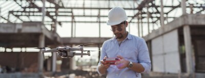
Today, construction companies can have regular flights of every active site and know exactly how the project is advancing and the available quantities of certain materials with incredible precision.
Another notable theme is the maturation of standards. ASPRS sessions on accuracy, classification, and best practices increasingly incorporate drone‑specific considerations. This is a sign of a profession that has moved past experimentation and into consolidation. The industry is no longer asking whether drones can meet mapping‑grade requirements; it is defining how they should. Standards discussions at Geo Week now treat drones as part of the same continuum as traditional aerial platforms, with expectations for deliverables, metadata, and quality control that reflect their central role.
As we wait for Part 108 to be released this year, the industry is now asking questions about larger flying times and, for the first time, a real competitor to traditional aircraft in larger areas and broader scales.
The cultural shift is equally important. The tone of the program suggests that drones are now viewed as professional instruments rather than gadgets. The early years of the drone boom were marked by excitement, but also by skepticism, concerns about reliability, accuracy, and regulatory uncertainty. Today, those concerns have largely been resolved through better sensors, more robust airframes, clearer regulations, and a generation of practitioners who have grown up with drones as part of their everyday toolkit. Geo Week 2026 reflects a profession that has embraced drones not because they are new, but because they are effective.
This acceptance has also expanded the scope of what photogrammetry means. The discipline is no longer defined solely by large‑format cameras and fixed‑wing aircraft. It now encompasses multispectral and thermal imaging, low‑altitude oblique capture, rapid‑response documentation, and hybrid lidar‑photogrammetry workflows, all areas where drones excel. The result is a more flexible, responsive, and creative profession, capable of capturing the world in ways that were once impractical or impossible.
As the geospatial community gathers in Denver, the conversations around drones will not be about novelty. They will be about optimization, integration, and the next frontier of automation. The profession has moved past the question of whether drones belong in photogrammetry. The question now is how far they can take it.


Comments