

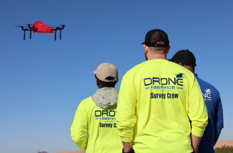
Companies that want drone data often face a long list of costs and compliance tasks before the first flight. A recent webinar hosted on Commercial UAV News and sponsored by Drone as a Service, a division of ZenaTech, looked at whether paying for finished data, rather than buying aircraft and building a program internally, can lower that barrier.
In a webinar moderated by ZenaTech’s Mark Masterson, insights came from panelists Linda Montgomery, vice president of corporate development at ZenaTech; Phil Franklin, vice president of operations and business development for the Americas at ZenaTech; Tom Bellis, marketing director at ZenaTech; and Donald Rudy, director of business development at Cardinal Land Surveying. A free, on-demand recording is available now for anyone who couldn’t attend the live conversation, with a quick recap of some of the 60-minute webinar below.
How the model works
Franklin described Drone as a Service as an on-demand data collection offering built on autonomous drones. A customer brings a question about a site, structure, field, or warehouse, and the company returns processed data. The company owns the aircraft, sensors and certified pilots, and it handles compliance, processing and integration with customer software. Franklin said clients do not receive raw data or a hard drive.
He said the service rests on three pillars: accessibility, autonomy and scalability. The drones use onboard AI for 360-degree obstacle avoidance and terrain following, and AI also handles much of the post-flight processing.
Bellis outlined five service lines: surveying and mapping, assessments and inspections, power washing, precision agriculture, and aerial photo and video. Customers span construction, oil and gas, solar, mining and government.
Where the network came from
Montgomery said ZenaTech began as a software company around 2017 or 2018. A supply chain project that involved monitoring plants in a field showed how hard it was to set up drones quickly, which led the company to build its own aircraft under the ZenaDrone name. It operates three manufacturing facilities.
The company then began acquiring what Montgomery called under-digitized legacy businesses, starting with land surveying, where the total station dates to the 1980s. Franklin said the network has grown in two years to about 40 businesses and locations across North America, Europe and Australia, including 29 acquisitions. Slides listed 29 land survey and geospatial firms, more than 40 professional surveyors, and more than 15 industries served. Montgomery said the company operates in 14 U.S. states.
The barriers
Franklin listed the obstacles to running an in-house program: choosing a platform and sensors, hiring and training pilots, keeping up with changing FAA rules, insurance, maintenance and data management. He said few insurers specialize in drone operations, and that some widely used drones could be removed from the market, leaving owners to absorb the consequences.
Montgomery said customers buy an outcome, such as a completed survey or inspection, while the provider keeps the technology current. She added that recurring work, including power washing and government construction, can be offered as a subscription that simplifies budgeting.
Reported results
Rudy said Cardinal Land Surveying joined the network in 2025. He said lidar-equipped drones have cut two to four days from some projects. The firm prices jobs both ways, traditional and drone, before presenting options to clients, and he said clients almost always choose the drone option, with savings of several thousand dollars on some projects. Many jobs still combine drone and ground methods, and flights near airports and government facilities can be restricted. He added that surveying still needs people, and licensing requirements vary by state.
Franklin said drones can reduce return trips for rework and can replace teams of one to 10 people doing quarterly warehouse inventory scans. He said AI processing has shortened some deliverable timelines from three to five weeks to between three days and a week.
Slides also cited 50 percent in project cost savings and 60 percent faster data delivery compared with traditional surveys. The webinar did not explain how those figures were calculated.
Fleet and data handling
Bellis described four ZenaDrone models. The IQ Nano is an indoor drone for inventory counts using barcode, QR, and RFID scans. The IQ Square handles inspections and power washing. The IQ Quad is the main survey and mapping aircraft, carrying lidar, multispectral and thermal sensors, with ground-penetrating radar in development. The ZenaDrone 1000 flies up to an hour, carries payloads and performs spraying and spreading work. Bellis said the company was among the first service providers to receive that authorization in Ireland.
Franklin said data can be hosted in the company’s environment or the client’s, including local networks for municipal and government customers.
Limits and outlook
Franklin said a large mine running daily stockpile flights could justify an in-house program, but he argued that needs tend to grow beyond the first drone. In Q&A, panelists said organizations with internal drone teams can use the service for added capacity or specialty sensors. Franklin cautioned that output depends on the inputs. “We can only give you as good as you give us,” he said.
Montgomery said clearer beyond visual line of sight rules are expected in the coming months and would reduce reliance on FAA waivers. Montgomery and Franklin both said the company plans to add locations and services.
A white paper on drone as a service for land surveying is available at droneasaservice.com.
Register for your on-demand recording, plus access to all slides, by following the link below.












Comments