

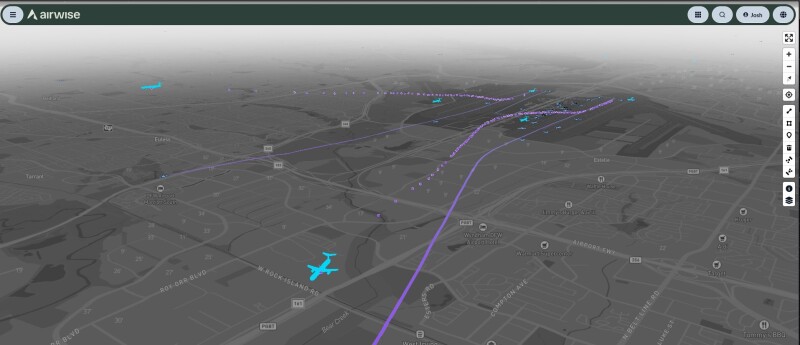
.png.small.400x400.png) A new strategic partnership was announced this week between uAvionix, a provider of airspace surveillance and communications solutions, and Airwise Solutions, a provider of drone operations software, UTM, and airspace operational intelligence. The partnership was developed to support Skyway Range through the integration of surveillance data from uAvionix FlightLine into the Airwise Platform and Nexus common operating picture, the latter of which was released this month. In the announcement, the companies say that this collaboration will deliver “enhanced airspace intelligence” to support safe, scalable BVLOS operations.
A new strategic partnership was announced this week between uAvionix, a provider of airspace surveillance and communications solutions, and Airwise Solutions, a provider of drone operations software, UTM, and airspace operational intelligence. The partnership was developed to support Skyway Range through the integration of surveillance data from uAvionix FlightLine into the Airwise Platform and Nexus common operating picture, the latter of which was released this month. In the announcement, the companies say that this collaboration will deliver “enhanced airspace intelligence” to support safe, scalable BVLOS operations.
Given the areas of expertise for the two companies at the center of this partnership, they will be able to provide operators with a more complete understanding of the operating environment in the given airspace due to the combination of uAvionix’s low-altitude ADS-B surveillance and Airwise’s UTM capabilities. By delivering deduplicated, low-latency cooperative aircraft data directly within the latter’s platform, the solution will improve situational awareness, operational coordination, and deconfliction for complex missions. FlightLine draws on uAvionix's nationwide FlightStation network and picks up cooperative aircraft on both ADS-B frequencies, 978 MHz UAT and 1090 MHz ES, with the data reaching the Airwise platform through a secure API.
The companies say that this integrated solution will provide:
- Real-Time Airspace Awareness through continuous visibility of cooperative aircraft operating in shared airspace.
- Enhanced Operational Safety with low-latency surveillance supporting informed decision-making and deconfliction.
- Proactive System Health Monitoring through real-time visibility into FlightStation sensor status and data integrity.
- Accelerated UTM Deployment with seamless integration that simplifies implementation for enterprise operators.
- Scalable Operations to support organizations ranging from individual flight operations to nationwide enterprise drone programs.
As noted above, this new partnership centers around operations at Skyway Range, a testing environment for uncrewed systems located in Tulsa, Oklahoma. The range covers an area of 1,200 square miles with a 114-nautical-mile perimeter, providing testing opportunities across a diverse range of topography and infrastructure in both urban and rural conditions. They fly over 300 days per year and partner with WindShape for indoor weather testing, all of which provide an ideal backdrop for testing as new types of missions emerge with BVLOS operations becoming more regular.
“By integrating FlightLine directly into the Airwise platform and Nexus COP, we are eliminating the burden of local sensor deployment while providing operators with trusted, FAA-grade airspace traffic data right out of the box,” said Thomas Jimenez, vice president of uncrewed systems at uAvionix, in a statement.
“As drone operations continue to grow in complexity, operators need more than individual software tools; they need trusted data delivered within a unified operational environment,” added John Powers, chief revenue officer at Airwise Solutions.
This new integrated capability is available immediately for participants at Skyway Range, the release said, as well as for enterprise customers utilizing the Airwise platform and Nexus common operating picture.
“We are building the future of aviation in the city of Tulsa and beyond,” said Jason George, Skyway Range general manager. “Having a world-renowned airspace data provider coupled with a local UTM provider sends a message to the region that this ecosystem produces world-class technology, not just world-class infrastructure.”











Comments