

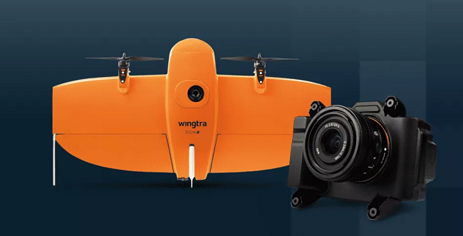
The introduction of Wingtra’s new RGB61 payload marks the latest in a recent series of innovations in the drone-based mapping camera market. According to Wingtra, the RGB61, which is compatible with the WingtraOne GEN II drone, allows users to capture 600 ha (1480 ac) in two flights, instead of three, and process 40 % less data for the same area. This, the company said, enables customers to map large areas in less time, which allows them to take on more mapping projects.
In February, Commercial UAV News reported that Atmos would begin integrating Sony’s new α7R mark III and IV cameras into its VTOL fixed-wing drones in an effort to improve coverage and accuracy in surveying and mapping applications. Wingtra’s RGB61 is also based on the use of Sony cameras. In a statement, Wingtra explained that the new camera “marks a leap forward for the entire drone mapping industry, as engineers have customized the Sony Alpha 7 Mark IV 61MP RGB camera to offer the most efficient, data-light UAV data solution on the market.”
Improvements like these in camera and sensor technology are critical to further the use of drones in mapping projects. In a recent Commercial UAV News report, “6 Barriers to Surveying and Mapping and How to Overcome Them,” industry experts weighed in the opportunities and challenges facing mapping professionals when using drones. Among the key takeaways from the report was the importance of capturing large quantities of accurate data.
Technologies like Wingtra’s new RGB61, the Atmos camera integration, and other recent advances, such as the Mosaic X mobile mapping camera and Event 38 Unmanned Systems’ decision to offer its fixed-wing mapping drone with a gimballed EO/IR camera from NextVision, show that the industry is working to meet the image quality and data capture needs of customers.
For Wingtra, that means offering a series of new features to help mapping clients. According to the company, the RGB61 has a 24mm lens to “optimize data capture efficiency and prevent distortion" and provides “seamless, in-app light-settings control, and reliable, ultra-high accuracy image capture with every flight.” The improved image quality and accuracy levels, Wingtra asserted, help "identify key features on maps and enhances matching point identification in photogrammetry post-processing software.”
Other features of the RGB61 include payload integration with the WingtraOne’s mission-planning app, “WingtraPilot, for “fine control in different light conditions.” The RGB61 can also be integrated “with a high-quality PPK GNSS data correction system,” which enables users to receive “survey-grade results and sharp imagery from every WingtraOne GEN II VTOL fixed-wing drone flight, all with minimum ground control.”
Moreover, Wingtra reported, the RGB61 benefits from partnerships with companies such as Propeller and Pix4D to support higher resolution.

.jpg.small.400x400.jpg)


Comments