

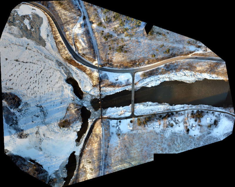
Many surveyors and mappers have long recognized the potential of drone technology in their work. Whether conducting operations for companies in fields like mining, construction, energy, and agriculture, surveying and mapping professionals have found ways to cut costs, enhance safety, and increase accuracy by integrating uncrewed systems.
The power and potential of UAV technology in surveying and mapping is highlighted in a recent article in American Surveyor. The article reports that traditional survey methods, including the use of scaffolding, rope, and mobile elevating work platforms, are “costly, time-consuming, and require a lot of workforces.” Moreover, the piece states, “the biggest disadvantage is that you can’t guarantee workplace health and safety with conventional methods.”
Using drones, on the other hand, keeps personnel away from potentially dangerous environments like “like rocky terrains, marsh, swamps, high altitudes, and others.” Ultimately, the article states, “drone surveying is better in every sense than the traditional methods. It’s less tedious, cost-effective, accurate, and safer.”
Still, despite all the advantages of UAV technology, not every mapping and surveying operation has fully embraced drones. Industry experts point to data workflow creation, customer expectations, training and personnel, and regulations as a few of the issues that hold some surveyors and mappers back from deploying the technology
Below is a look at six barriers to drone adoption in surveying and mapping—and what can be done to overcome those challenges.
1. Creating Drone Data Workflows
How do we create drone and data collection operations tailored to specific surveying and mapping projects? What factors must be considered to ensure accuracy and usability?
Josh Adams from Adams Surveying Company, LLC, a firm that provides surveying, mapping and construction services throughout Texas, stated that one of the problems of workflow creations is that many drone professionals simply don’t have the knowledge to develop effective data workflows.
“It is difficult to create a workflow when you do not understand the root of what is needed from the end user, be it an engineer, site intendant, FEMA, title company, etc.,” he explained. “Same goes the opposing way—it is difficult to make a workflow from the survey standpoint when many surveyors do not know the capabilities of the drone technology.”
Adams said that surveyors and mappers “need the pilots’ collaboration to open their eyes to a new generation of tools and equipment to marry into their existing workflows.”
Ultimately, Adams believes that “workflows should be developed from the surveying side, and pure drone pilots should work to collaborate with surveyors rather than try and take on the industry as an individual.”
To help in this process, experts like Adams state that proper training is essential, along with collaboration with clients.
During a 2022 Commercial UAV News webinar on surveying and mapping, Joe Hutton, Director for Inertial Technology, Land, and Airborne Products at Applanix Corporation, talked about the importance of creating “a complete survey solution.” He explained how his company works closely with its clients to create workflows that analyze data that has been captured by cameras and lidar to “get the end-user what they need.” Matching client expectations with the right technology is key to creating a useful drone data workflow.
2. Defining the Accuracy You Need
Some surveyors, mappers, and clients attempt to capture more data than they really need. But what happens when we attempt to capture more data than necessary? And do we need 2mm accuracy for every job?
Josh Adams said, “for different jobs, different degrees of accuracy are required.” He explained that the degree of accuracy required to collect data on a large construction project, such as the building of an apartment complex, “is very complex and difficult for many drone-based operations.” however, he said, “a survey of raw land is easier to produce and qc with fundamental skills and knowledge.”
“Whether we’re mapping raw land or dense urban areas with drones, it takes a deep understanding of data extraction software to be proficient,” Adams stated. “Most raw land sites can be detailed with fundamental software skills; however, you still need an understanding of how the algorithms and tools are working to find the flaws and manually edit as needed.”
The other side of the accuracy, Adams continued is understanding coordinate systems. “Is the site in a Published system or is in in a Local Coordinate System? Do we know what map projection to use? How do we correct and adjust for the differences? These are highly impactful items when dealing with engineering design that can be very costly if incorrect data is represented,” he said.
The need to perform a full analysis of the project and match the degree of accuracy required to the parameters of job can save time and money and ensure that clients get the necessary data. “Finding the right tool for every job is very important,” Adams said.
3. Capturing the Accuracy You Need
Once you’ve determined the level of accuracy you need, you now face the challenge of collecting that accurate data. Unfortunately, “capturing accuracy” is a challenge for many seeking to use drones in surveying and mapping. For many, the solution comes down to a trade-off between simplicity and accuracy.
In an interview with Commercial UAV News, Aerotas founder Logan Campbell explained that some automated, cloud-based solutions “lack the accuracy and customization that comes with more manual processing. A lot of problems or errors that would be caught in manual processing might slip through the cracks in cloud-based solutions, so it’s important to be very careful.”
Campbell stated that “just a few mistakes in accuracy, processing, or having to revisit a project site will counter all of those time savings, make you look bad in front of a client, and cost money. A single error in final accuracy might delay a project by a whole day or more.”
He said that “having the expertise to prevent errors before they happen and catch any errors in a timely manner is the best way to save money. This is why expert processing is the best choice for a lot of companies.”
4. Regulations
Everyone who interacts with the drone industry, including surveyors and mappers, must confront the ongoing challenges of complying with local, state, and federal regulations and adapting to changes in the regulatory environment. Fortunately, many believe that the regulator environment is improving, and the process of receiving waivers and approvals for new drone-based operations is getting easier.
During the surveying and mapping webinar, Colin Romberger, Solutions Engineering Manager at Skydio, explained how his company helps customers get BVLOS waivers. Working through the approval process over and over, and proving, repeatedly, that operations can be flown safely, “has given the FAA a lot of confidence” in his company, Romberger said.
“We’re seeing quick turnaround times” for waiver applications, he reported. “In general, I think things are moving in the right direction.”
For surveyors and mappers in Europe, however, many report that the regulatory environment is still challenging. At the same webinar, Philipp Amon, Manager of ULS Business Division for REIGL, explained that “there is a national process in each country” to receive approval for longer, higher drone operations.
“There’s quite a lot of paperwork to get to next-level flights,” he said. “This process is not yet automated, and it takes a lot of time. I hope this will be improved in the next couple of years.”
5. Training and Personnel
To use drones to optimal effect, companies must get their staff fully trained on hardware, data collection systems, and analysis software. But training can be a challenge, as there is a perception seasoned surveying and mapping pros may be reluctant to learn about new ways of doing their jobs.
During surveying and mapping webinar, Skydio’s Romberger said that “training is a huge part of getting folks to be proficient and being able to generate valuable products that are going to move the needle and really show their worth.” Romberger explained that his company, like many others, has designed an easy-to-use platform to operate its products “because we know that it can be a struggle to learn new systems and the complexity involved in learning new systems that are designed for surveying and mapping purposes.”
Creating easy-to-use systems and getting employees properly trained on those programs is essential to get the most of drone-based surveying and mapping operations. Many UAV experts feel that the best way to learn how to use drones in the industry is to be a seasoned surveyor or mapping first and then learn how to apply drone systems to the work.
Fortunately, many surveyors and mappers are enthusiastic about learning new systems to improve the efficiency, accuracy, and safety of their operations. At that same Commercial UAV News webinar, Joe Hutton, Director for Inertial Technology, Land, and Airborne Products at Applanix Corporation, said that he has seen “a real eagerness” among surveyors and mappers to learn about drone technology.
“I think people realize that the only get out what they put in,” he said.
6. Managing expectations
While many surveying and mapping professionals have worked with clients who unreasonable expectations about what drones can do, some assert that expectations can be managed through education and collaboration.
During the webinar, Joe Hutton from Applanix said, “I think there is an educational process in what this technology can bring. We’re still not beyond the stage where this is second nature.”
Building on that statement, Romberger explained that Skydio “spends a lot of time working with our clients” and “we discover that they see the technology for the first time they realize that there a lot of other things that we can do.” Instead of tamping down expectations, he said that, many times, they discover “new and emerging uses.”
Watch for new installments of our "6 Barriers to Drone Adoption" series in the weeks to come.


Comments