

The value that drone operators can find at the software layer is becoming a bigger and bigger topic as UAV technology continues to mature. Drone hardware is on its’ way to becoming commoditized, and while that process won’t be a simple one, it will and already has highlighted why utilizing software that will easily enable and create opportunities for operators is so critical.
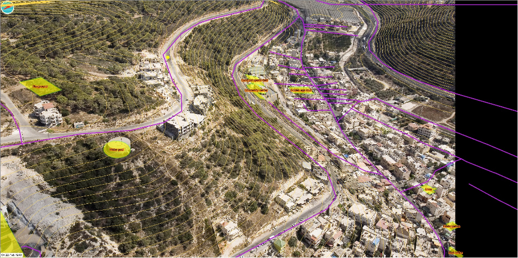
This is a fact that companies like DroneDeploy and Pix4D have been talking about for a long while now, but professionals that work with oblique imagery recognize this requirement in a very different way, because they have very specific needs. Idan Computers Ltd. has created Oblimapper to meet these necessities with a powerful and robust solution.ObliMapper is an image capturing, handling and analysis tool, designed to combine the benefits of orthophoto with the rich detail of oblique photos. It’s also designed to work for and with off-the-shelf drones. With its’ 360 view of the area, ObliMapper is designed to transform visual data into accurate, meaningful and actionable intelligence. In some ways it’s the culmination of the work the company has been doing for over twenty years.“We have been developing software for oblique images for almost two decades, working with all the major aerial oblique camera manufacturers,” said Joseph Freund, CEO and founder of Idan. “They were incredibly expensive systems though, and that limited the audience. Drones have been a real game changer, and we decided to adapt this technology to present the market with something they wanted and needed.”As Art Kalinski detailed in his excellent article, Metric oblique image collection with UAVs, the system can be boiled down to four stages: flight planning, image capture, processing and analyzing. You can watch the video below to see exactly what that looks like: With just about any off-the-shelf drone, users have all they need to fly the drone 100% autonomously. Using a sophisticated algorithm and template system, the drone takes off, flies and lands in less than 15 minutes. Once the data has been offloaded to the computer, Oblimapper software provides users with a full project in less than 3 minutes.The ease of use is what’s especially important to highlight, both in terms of being able to use the software with just about any drone as well as how the system processes and analyses the information autonomously. Users can view the up-to-date oblique images from all directions, utilize the accurate measurements on the oblique images and get specific details around terrain analysis, contour lines, slopes, visibility etc. Some users have mastered the system after only using it for three to four hours.As ever though, the details around usability are critical to understand, so what types of professionals are using this system? And how are they able to utilize the information the system provides them?“In terms of customers, the variety of users we have are pretty amazing,” Freund said. “Entrepreneurs are using it to monitor large construction sites, municipalities are using it to control safety and enforce regulation, insurance companies are using it to get a better knowledge and understanding of a situation and cellular antenna companies have used it for maintenance. We’ve also see it used by fire brigades, rescue teams, and many more.”As a specific example, the CEO of an Israeli railway company is constantly monitoring, from his smartphone, the data that the system is generating. Idan also has a customer tasked with redesigning a part of Tel Aviv, and they’re being helped by an international team of consultants located across the world. The program allows them to share the exact the same images with one another so they can all focus on the exact same issues.Idan has up until this point been focused on the market in Israel, but they’re looking to extend their product and brand across the entire world. With that in mind, what’s the best way for someone to see if ObliMapper is the right fit for them or their project, regardless of where they’re located?“The best thing anyone can do is to try it out for themselves,” Freund concluded. “We are providing an evaluation kit someone can use with almost no learning curve. We strongly believe that this method will be a standard way to use drones for many other fields to come. It is a real affordable 3D for the masses.”

.jpg.small.400x400.jpg)


Comments