
We all know that drones are capable of mapping a user-defined horizontal area automatically, and really, there’s no shortage of software that can utilize automation to create incredible efficiencies. Whether it's stereographic mapping or software that automates the processing of drone-based imagery into photogrammetric products, professionals across the world have been able to use this technology to make real differences in horizontal areas. Recently though, Latvia-based SPH Engineering launched an automatic vertical scanning tool to do the same, but, as the name states, vertically.
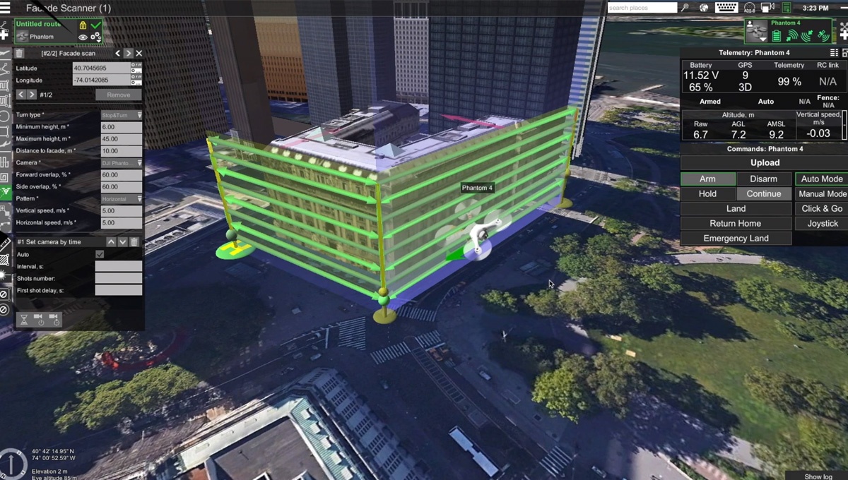
Founded in 2013, SPH Engineering is the company behind the Universal Ground Control Software (UgCS), a complete platform to plan and fly drone survey missions. The software works for various types of missions, such as standard land surveying photogrammetry, magnetic and other low altitude mission planning, PV Solar Panel and Powerline inspections, Ground Penetrating Radar (GPR) surveys, and more.With the launch of a new software update, the company introduced what they call the “automatic Facade Scan tool” for drone inspection mission planning, “a time and cost saver for construction, engineering and mining industries”. This tool provides pilots with a completely new way to automatically create accurate 3D models of buildings or cultural heritage objects, find heat leaks or damage to walls, examine open quarries, or even unstable pits.Similar to horizontal mapping missions, the Facade tool allows pilots to draw a vertical plane over the desired area just as easily. Then, pilots need to specify the distance to the area in question, as well as side and forward overlap, for the software to automatically calculate the optimal flying path and perform the mission. In addition, it supports the import of 3D objects and custom DEM data using the terrain-following function.Available under a lifetime license for $600 or $2000, or a temporary license of between 1 and 3 months for $69 or $199, respectively, UgCS supports most UAVs, including DJI drones, and is MAVLink compatible.Subscribe
The information you submit will be stored and used to communicate with you about your interest in Commercial UAV News. To understand more about how we use and store information, please refer to our privacy policy.
March 1, 2019
SPH Engineering Launches an Automatic Vertical Scanning Tool for Drones

Want more stories like this? Subscribe today!


Technology in general makes João Antunes tick, but the specific ways it has created and changed the landscape in IT, gaming and computers ignited curiosity that’s turned into a passion for him. As the son of a journalist writing about how these industries have emerged and evolved, he has an incredible perspective when it comes to understanding the kind of disruption new technologies can create in a given space. He’s committed to showcasing what that disruption will mean for professionals as they work to utilize brand new pieces of hardware, software, systems and processes.
Featured Report
Featured Authors More Authors ›

Featured Authors


Newsletter Signup
Our Events


Our Events
September 1-3, 2026 • Las Vegas
February 23-25, 2027 • Salt Lake City
Comments