

As the number of surveys using UAV lidar and photogrammetry solutions continue to increase, solutions to improve and verify accuracy become even more critical to assure surveys are executed properly and achieve the specified level of accuracy. Routescene, a developer and manufacturer of integrated UAV 3D mapping solutions, developed new Ground Control Targets (GCT) to improve lidar survey results and identify any errors early.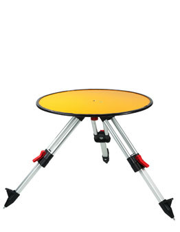
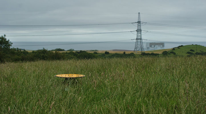
Deployed on known and accurately co-ordinated Ground Control Points (GCP) before a UAV lidar survey, Routescene’s GCT are large, robust, and wind-resistant discs (60cm diameter and 5.5kg weigh) that attach to mini tripods designed for quick repositioning and leveling. To enable accurate leveling and remove the need for a tribrach, each GCT comes with a built-in bubble level. According to Routescene, establishing GCT brings many benefits including: checking for errors in your survey to achieve robust and quantifiable results; the ability to calibrate the equipment on every project; prevent unnecessary repeat visits to remote sites; simplify post-processing; and avoid data alignment issues. While the number of GCT may differ from one survey area to another due to its size, Routescene recommends 4-8 targets, used for the boresight calibration and as checkpoints, for a 500 x 500m area.
“We advocate that every UAV lidar survey has ground control established,” Gert Riemersma, Routescene’s CEO, wrote. “Setting Ground Control Points (GCP) helps to demonstrate a certain level of accuracy has been achieved. Also avoids data processing issues and assists with the calibration of the sensors on the drone: all of which improve the confidence in the accuracy of the survey.”
In a lidar point-cloud, identifying individual features can be a difficult task since the points are discrete with a space between each individual point. Covered with highly retro-reflective material to provide high-intensity returns, after 200-300 hits by the lidar system’s lasers, GCT are easily identifiable in the resultant geo-referenced point-cloud. With this, Routescene’s post-processing software, LidarViewer Pro, can easily and automatically generate Quality Assurance Reports.
“It is typical in lidar surveys to select a flat surface and analyze each axis individually, which is mathematically far more robust,” Riemersma added. “However, in practice finding a flat surface in a highly vegetated undulating terrain is a tricky task. The solution… utilize dedicated Ground Control Targets during a lidar survey to enable ground control.”
Available now, Routescene’s Ground Control Targets package comes with four Ground Control Targets, four mini tripods, and one tough carry bag with a handle for four GCT.


Comments