


Exyn Technologies, a pioneer in SLAM-based LiDAR scanning technology and autonomous robotics, has launched Exyn Nexys, a revolutionary modular 3D mapping solution. Designed for professionals in construction, AEC, geospatial, and mining industries, 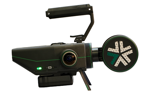 Nexys is a complete mapping and surveying ecosystem that allows users to quickly capture highly accurate, colorized, real-time 3D point clouds in complex, dangerous, or inhospitable environments.
"We are excited to introduce Exyn Nexys to the world, a testament to Exyn's dedication to leading-edge innovation and our commitment to transforming the mapping and surveying landscape," said Brandon Torres Declet, CEO of Exyn Technologies.
Here’s a look at some of the features of Exyn Nexys:
Unmatched Modularity for Every Mapping Scenario
Nexys’ groundbreaking modular design allows for deployment in various configurations, including handheld, backpack-mounted, vehicle-mounted, drone-integrated, or via ground robots. Highly versatile and ruggedly ergonomic, the Nexys can be quickly and easily switched between a variety of configurations, giving users the flexibility and cost efficiency to use one device in any mapping environment - inside, outside, below ground, short or long distance, autonomous or piloted, connected or not connected to communications networks.
This adaptability makes Nexys an essential tool for comprehensive mapping across diverse environments, from indoor and underground spaces to rugged outdoor terrains.
Advanced Technology for Optimal Performance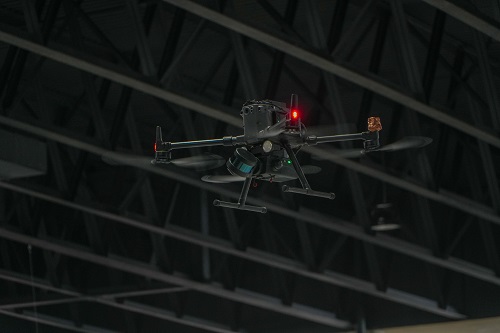 Equipped with state-of-the-art LiDAR technology and Exyn's proprietary SLAM algorithms, Nexys delivers survey-grade results without a pilot. The operator simply sets the area to scan, and the system determines its own route.
Our solution offers top-tier data capture speeds and real-time point cloud colorization. Attached to a robot, its Autonomy Level 4 (AL-4) capabilities facilitate intelligent autonomous navigation through dynamic, complex environments, ensuring thorough coverage even in GPS-denied settings, a significant advancement in autonomous mapping. Start with mapping only, then upgrade to full autonomy when you need it.
Engineered for the Harshest Conditions
Constructed to IP67 standards within an ISO 9001 certified framework, Nexys is built to withstand the toughest conditions. Its ergonomic design, coupled with a comprehensive suite of accessories, including GPS modules, protective cages, and Drone Link for robot integration, expands its utility across numerous mapping scenarios.
Real-Time Data Visualization and Precision Accuracy
Combing integrated hemispherical cameras with fast, on premise processing, Nexys allows you to get real-time visualization of your captured data with full detail and colorization in the field to ensure the scan area is correct and complete before you leave the site. Adaptable to changing environments, Nexys’ SLAM-based spatial mapping is capable of capturing up to 1.9 million scan points per second at up to 1 cm, while continuously updating the map as new data is received. These features make Nexys ideal for precision-driven surveying and mapping operations.
Deployment Options for Every Use Case
The Nexys has been designed to work with a wide variety of deployment options to enable efficient and accurate operations for surveying, mapping, inspections, and more. And the Nexys custom mounting interface ships with all units and may be used to securely mount Nexys in a variety of mounting configurations.
- Aerial Robots: Use our autonomous mapping with a growing number of drone models or choose mapping-only on a compatible drone that you pilot yourself.
- Terrestrial Robots: Choose to use our autonomous mapping with a growing number of ground robots, map the route yourself with a compatible self-piloted robot, or use the robot’s integrated semi-autonomous mode.
- Handheld: Nexys’ lightweight, rugged, ergonomic design makes it easy to carry for handheld scanning operations.
- Backpack Mount: Our ruggedized, water resistant backpack holds and powers Nexys while scanning, and also serves as a storage and travel case.
- Vehicle Mount: Nexys can be easily and securely mounted to almost any vehicle or surface, allowing you to capture a complete map in rugged environments.
About Exyn Technologies
Exyn Technologies is at the forefront of autonomous aerial robot systems development. Renowned for its commitment to innovation, Exyn focuses on crafting solutions that elevate safety and efficiency in challenging operational environments. Its commitment to delivering superior products and services continually shapes the future of autonomous exploration.
For more info, visit our website: www.exyn.com/products/exyn-nexys


Comments