

PBS Engineering and Environmental (PBS) provides professional engineering and surveying services throughout Oregon, Washington and Idaho. They’ve been named as a “Top 500 Design Firm” by Engineering News Record, but it’s their adoption and integration of drone technology that caught our attention. The company has unveiled a new program that uses drones for surveying, engineering, and aerial data collection, and it’s one that’s opened up brand new opportunities for them and their clients.
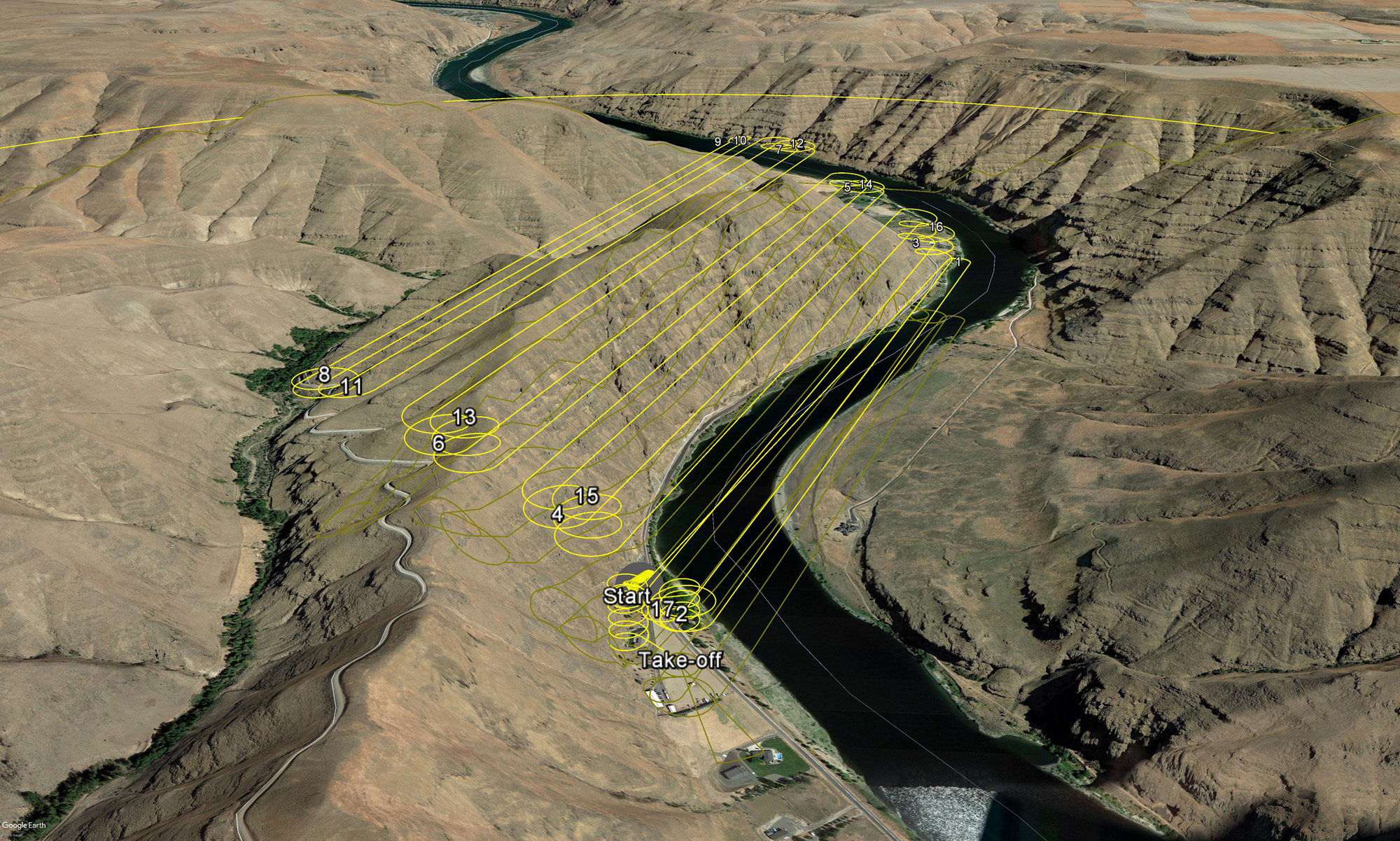
What’s interesting is that many of those opportunities are directly associated with the work they’re already doing. PBS recognized the difference drones could make in terms of supporting their surveying department, but the way in which they could use the technology for their engineering and environmental service areas was just as important. After taking a look at the technology, the team realized they could gather data they have been collecting via ground-based survey crews from a different perspective.However, it was the ability of the technology to be integrated into the work and tasks that they were already doing that was the critical factor in their decision to adopt the technology and create an entire drone program. Integrating the TechnologyPBS offers a fairly broad amount of services for a company of their size. Their professional engineering, environmental, industrial hygiene, planning, and surveying offerings have established their reputation in the industry. That reputation was something Mark Leece, Principal Engineer at PBS, knew he needed to address when it came to drone adoption.“When we first started looking at the technology, our senior survey managers approached it from the perspective of, ‘can we really get the data that people claim to be able to get from this technology?’” Leece said. “We tested it on a site that we had worked on a couple years ago, so we had data to compare it to. When we were able to process the data and start the QA, we realized it was as accurate as what we were getting from typical topographic surveys. Since then, we've refined it further. That was what won over some of the seasoned surveyors.”The site Leece mentioned was about 400 acres, and they used a fixed wing drone to fly it. They were able to fly that site in four hours while original survey took a two-man crew about a week. That alone showed an incredible amount of efficiency, but there was something much more important that the team was focused on.“Being able to easily incorporate the data gathered by the drone into our workflow was the key,” Leece confirmed. “The drones are embedded into our survey group, because it's not so much that we're selling a drone service as in how the technology service supplements and even enhances our existing workflow. We couldn’t be producing files that are too bulky to dynamically use with our software. Once we worked out how we could integrate the technology into our existing workflow we knew we’d be able to use it. That's the real differentiator.”Some people think of surveyors as a group that isn’t quick to embrace new technology, but the distinction is usually more of a technical one than a philosophical one. Once those experienced surveyors at PBS could confirm the data generated from the drone could be verified with their traditional technology, the apprehension around adoption and the creation of this drone program was mitigated and allowed them to determine exactly what adoption looked like. Drone Program LogisticsBeing able to turn drone data into actionable information is the focus for professionals in various industries that want to be able to utilize the technology. If there isn’t a process in place for surveyors to refine the data and create usable, accurate point clouds, then it's just a mass of info that takes up a lot of server space. How surveyors get that refined dataset is the key. It’s really not just about capturing the data, but what you do with that data once you have it.“We're on a measured, steady growth pattern,” Leece said. “The number one thing with the program is to make sure that we are operating safely on everything we do and that we are obtaining quality data. We have a UAS program lead who is the backbone of the program, does all the flight planning, compliance, processing, etc. That’s allowed us to figure out what deployment across the region looks like.”PBS has different people operating and deploying the technology locally, while all of the data is processed within their office. This approach has allowed them to integrate the technology into their workflow, and that represents the biggest factor in terms of adoption. They don’t look at their UAS Program as a stand-alone service, but instead as a compliment to something they’re already doing.None of that means there haven’t been challenges with getting that program established or even taking it where they want it to go. Process issues aren’t the only logistics associated with drone operation that need to be worked out, as regulation has long been the number one concern for operators. However, in this post-Part 107 world, it’s interesting to see how these regulatory issues have evolved.“The largest frustration right now from a regulatory perspective is seeing the integration of Part 107 on a local level amongst the various jurisdictions we operate within,” Leece admitted. “The ability of local authorities to understand waivers, flight clearance, and even what Part 107 actually is and allows for is probably our biggest frustration. It’s a dynamic that's rapidly evolving, but education on the local level is an area where there’s room for improvement.”We’ve talked about the clash between federal and state authorities when it comes to drone regulation, but it’s important to not forget the local piece of this issue. Details associated with process and regulations need to be sorted out when establishing a drone program, and those challenges have to be continually monitored. Luckily, the benefits of doing so can be seen and measured in multiple ways. Lessons LearnedBeing able to see and quantify a return on investment (ROI) associated with a UAV purchase has been a major topic of interest for various professionals, but the challenge with doing so is often a result of efficiencies that drones create but are tough to measure. Nonetheless, the differences the technology represents are very real to the people using them.“We knew there was going to be an investment with this technology, so we quantified that in the business plan and associated it with the operation,” Leece said. “The jury is still out on a definite hard line ROI, but I can tell you that the benefits we've seen on projects are there.”As an example of the benefits he’s talking about, Leece mentioned a road project his team was required to conduct a land survey for. They couldn't really survey this surface because there were rock overhangs, but the drones allowed them to capture info in order to create a point cloud. The drones served a dual purpose when permitting regulations required archeologic surveys of rock cliff surfaces for Native American petroglyphs along the project area. However, access was extremely limited. Using aerial imagery collected for the survey, Leece and his team created a 3D model with high-resolution photography that enabled them to actually go back and view this cliff face to satisfy that requirement. That represented an untold amount of savings for their client in terms of both expense and scheduling.As ever, tangible ROI can be difficult to quantify when boiled down to raw numbers, but the people using these tools see and understand the difference. That’s part of why it’s essential for the right people to see things through with the technology.“I think having a champion at the executive level in any organization is critical, because it takes a commitment of resources, and there's definitely a learning curve,” Leece mentioned. “I caution people not to underestimate the difficulty of setting this up, and not even setting it up, but then integrating it into an existing workflow and how they can do that without upsetting their existing processes.”There continues to be a decent amount of hype associated with drone technology, and the inability to quantify an ROI continues to create issues. Nonetheless, proponents of drone technology take the position they do because they know what kind of difference it can make. Professionals are not interested in cashing in on the commercial drone industry, but instead on leveraging the business opportunities it can create. Those opportunities are real today, and they’ll continue to become that much more powerful and pervasive.


Comments