

How drones are augmenting and improving the approach individuals and organizations can take is a topic that pops up quite often. Regardless of the use case or industry, it’s obvious that UAVs are being utilized to give operators insight and info that they can use or hand-off to make real-world impacts. A recent scrub through the popular #dronesforgood hashtag brought up a video that showcases this reality in a way that isn’t often detailed.

Jarlath O’Neil-Dunne
 Your specialization relates to building systems which are capable of extracting actionable information from massive amounts of geospatial data. That would seem to be especially relevant to advances in UAV technology, as these devices can obviously gather an enormous amount of information. What can you tell us about the impact drones have made in your field?Back in 2011 Tropical Storm Irene dumped close to a foot of rain in some portions of Vermont, almost overnight, resulting in major flooding. Vermont is a state with high topographic relief and so our transportation network is often situated in close proximity to our hydrologic network. The floods, which were the worst in decades, devastated our transportation infrastructure. Our state’s Emergency Operations Center and GIS offices were flooded so my lab took over coordinating the imagery acquisition and exploitation. Satellite imagery is wonderful, but for an event like Irene we simply could not get the imagery we wanted at the resolution we required for the locations requested in a timely manner.Adding to the aforementioned issues is the fact that Vermont is the cloudiest state in the union; not ideal for satellite imagery. Commercial UAVs were just gaining ground at the time and we were very fortunate the land a US Department of Transportation grant that enabled us to delve in to UAV operations. Have drones been able to solve critical or persistent problems/issues that previously didn’t have a great solution?Drones are unique in that we can get high-spatial and high-temporal resolution imagery and other data products at a very low cost. For small area mapping, remote sensing of this kind simply was not affordable in years past. Just as important as the drones are the advances in digital photogrammetry that allow us to go from data acquisition to mapping-grade products in hours.
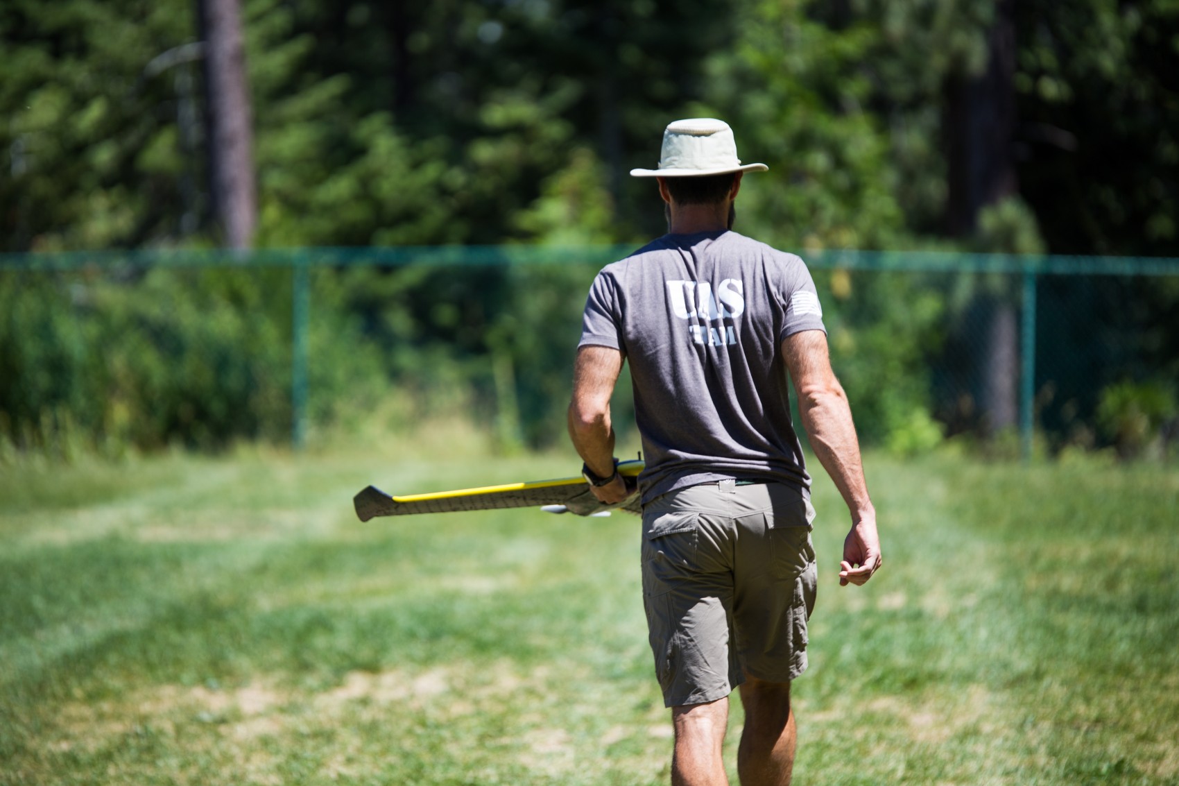
 What sort of opportunities have drones opened up for you, or for the industries that you’re involved with? We helped the Town of Planfield, VT understand the amount of woody debris in one of their streams, the Great Brook. Woody debris was clogging their bridges during periods of high runoff, causing a lot of damage. The town has a population just over 1,000, so they don't have the tax base to keep making these expensive repairs after every storm. There was no good way for the town to survey the amount of woody debris before and after these storm events to find out what was going on. There was too much area to cover to do the surveys on the ground and aerial mapping was far too expensive.Imagery collected via UAS proved to be the perfect solution. We were able to show the town that hundreds of pieces of woody debris moved through the system during major storm events, with only a dozen or so getting caught in the bridge and causing all the problems. This information gave the consulting engineering firm the information they needed to come up with an optimal bridge design that will withstand the amount of woody debris that moves through the Great Brook during these events.Let’s talk about another specific use of this technology that is detailed in the video above. First though, tell us about the University of Vermont’s UAS Team. How did this team come together, and what sort of work does it do?We realized there was extensive interest in UAS technology in the state, but that the cost of getting into UAS in terms of buying the systems, developing the expertise, getting the FAA approval and building the back-end IT infrastructure was too high for most organizations. The UAS Team's mission is to bring mapping-grade UAS technology to the state of Vermont.We work with the private, non-profit, and public sectors. We consider the UAS Team to be an incubator for the technology in Vermont. We also assist the state during times of disaster. Our team can deploy within an hour of being notified.
 The ice flooding that occurred in February of this year along the Winooski River in Middlesex, Vermont caused some major problems for the area. How and when did the UAS Team get the call about helping out?The state asked us to acquire data along the Winooski River, one of the major rivers in Vermont, which was experiencing ice jams and flooding at the time. We collected data at key locations where the railway lines were in close proximity to the river to confirm that the water levels were not about to flood the tracks (millions of dollars in improvements were made to the tracks following severe flooding that occurred in 2011). We then headed down to Middlesex, VT to document the high-water conditions that resulted in the closure of two roads. Immediately after the flights were completed we headed over to the state's Emergency Operations Center to provide the data to the emergency staff.Was cataloguing the damage more about figuring our how relief efforts would be impacted in the present, or what that documentation meant for future assessments?In this case the UAS data was used to document the conditions both for public outreach but also to help understand what could potentially be done in the future to mitigate these effects.The great benefit of UAS imagery is that it gives us a definitive record of the flood conditions so we understand how flooding events compare to one another. The video mentions that transportation planners involved in response efforts had access to the imagery within an hour after flight operations were completed. What kind of a difference did having that info make to them? How long would they normally have to wait for that kind of info?We processed the data during the car ride to the Emergency Operations Center, so they were very excited to see same-day imagery for an event. In the past the only way they would get same-day imagery for any type of event was to use manned aircraft. Not only are UAS cheaper, but we can produce geospatial products, not just pictures. The big difference is that with our orthorectified imagery emergency staff can integrate it with other datasets using GIS software.
 How would this info have been documented otherwise? What kind of an advantage do drones possess in this regard over existing tools and techniques?In cases such as flooding we simply never have good data on the full breadth and extent of flood. We might have some ground photos, but to make comparisons between events you need data with coordinates, and a few GPS points just don't cut it. Never mind the fact that manually surveying the high water during a flood can be downright dangerous. Increasingly, we are seeing that in order to qualify for disaster funding you have to clearly document the damage. UAVs allow us to acquire this evidence at exactly the right time and process it so that the damage can be tied to a specific location.What kind of simulations were you able to run once you constructed 3D models of this environment? What sort of impact did that info make to relief efforts?The 3D models allowed us to confirm that the railway lines were high and dry and that the river would have to rise 4 meters (highly unlikely) before it would affect the tracks.Thanks to the workflows that we developed making these types of 3D measurements was not only easy, but safer, faster, and more cost effective than traditional field surveys.
 Was this type of application of drone technology something you had always envisioned?We certainly hoped that the UAV workflows we developed would play a role in emergency response, but things have gone better than I have hoped for. We have a great team that spent hundreds of hours dialing in the standard operating procedures, which allows us to conduct UAV operations under challenging conditions and turn the data products around almost instantly. Do you see applications like this as the culmination of UAV technology, or a stepping stone to something more?It's not enough to fly the area, or to take pictures; you need to produce actionable information. We need to continue to work to integrate UAS data products with other geospatial products if we are to effectively map and monitor over time.UAV operations may be done across small areas, but the resulting datasets can be very large. A single UAV mission can yield still images, videos, an orthorecitified image mosaic, a 3D point cloud, and a raster surface model. Building the systems to make such datasets discoverable and accessible is crucial if we want UAS data to be tightly integrated into our decision making process. What has you most excited about how you are or will soon be using UAVs?I am most excited about integrating UAVs into asset management. Our nation's transportation infrastructure is old and badly in need of repair. UAV technology will allow us to inspect transportation assets much efficiently than ever possible before.I am also excited to apply the technology to assessing wildlife. There are a lot of issues on Lake Champlain regarding the damage that the cormorant (a type of bird) is doing to some of the island habitat. UAV surveys are an efficient means by which to assess the population. Plus, a number my colleagues on the UAS Team are wildlife biologists and they would like to work with real birds, not just the mechanical type!DISCLAIMER: The views, opinions, findings and conclusions reflected in this presentation are the responsibility of the authors only and do not represent the official policy or position of the USDOT/OST-R, or any State or other entity.


Comments