

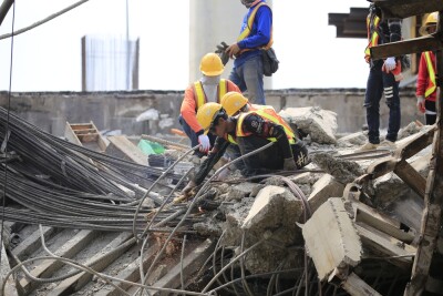
In the United States and across the globe, to aid in a wide range of emergencies and incidents, public safety professionals increasingly deploy drones in the air, on the ground and underwater. These drone responders' numbers continue to expand as more entities adopt drones for use in public safety operations. This year, over 600 public safety and related industry professionals convened at the second annual National Public Safety UAS Conference, in Williamsburg, Virginia. Led by the DRONERESPONDERS non-profit organization, a key partner of the Commercial UAV Expo, participants experienced and discussed the latest technologies and trends in this critical sector. Read on to surveil (pun intended) the top 5 key takeaways from the event.
Trend #1 - Drone as First Responder
This rapid deployment enables the drones to provide crucial visual information, allowing responders to assess whether the situation requires law enforcement, fire services, medical assistance, or to divert assets from a non-emergency. DFR systems also leverage software that provides multiple stakeholders, from dispatchers, command staff to on-site officers, access to real-time footage.  This shared situational awareness equips responders with vital information before entering potentially hazardous environments, enhancing effectiveness and safety.
Flying Lion, a drone service provider (DSP), helps agencies develop DFR programs for their communities. According to company founder Barry Brennan, “DFR has proven to save lives and is the future of law enforcement.” He continued, “We are seeing both fewer and newer officers across the board. DFR can extend the experience and the range of the force.” Brennan applauded both the Federal Aviation Administration (FAA) for leaning forward on the regulatory front to enable DFR and other public-safety focused missions, as well as the other companies creating DFR solutions for our brothers and sisters in blue. (Watch Barry and Steven Katz from Flying Lion on the Dawn of Autonomy podcast).
One such company, BRINC, known for their focus on technology in the service of public safety, announced an impending summer roll out of their outdoor Responder drone, as part of its larger DFR ecosystem. Currently planned to launch in both Schenectady, NY and Hawthorne, CA, BRINC’s DFR offering will involve a larger version of the Lemur 2, with 40 minutes of flight time, GPS and LTE capabilities, 20x optical zoom high definition video, thermal camera, 2-way communications with a siren, mesh networking and a larger payload capacity. This bigger and better drone will actually be able carry BRINC’s original Lemur2 closer to the desired location and then use its grab-and-release mechanism to remotely launch it into action. The Lemur 2 itself provides unique capabilities that differentiate it from other public safety drones. Among these, it boasts glass breaking capabilities with blades that spin at 10,000 rotations per minute. The company purposefully designed its new Responder to offer enhanced overwatch, search and rescue and support for a myriad of other operations.
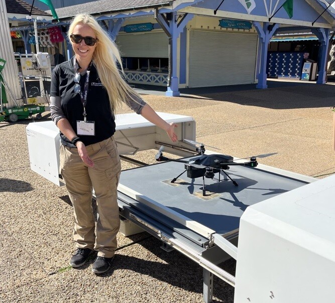
Trend #2 - Drone-In-A-Box
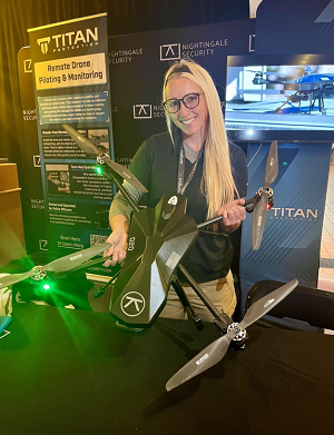 Valerie Wiehl, Drone Deployment Engineer at Silicon Valley-based Nightingale Security, discussed her company’s DIB for DFR. Upon activation of a security alarm, the system initiates automatic dispatch of the drone (called Blackbird) to the alarmed area, facilitating live video streaming to the security team. Operators also have the ability to establish recurring, autonomous patrol missions with specific parameters or to fly the drone manually. For example, San Pablo PD apprehended a suspect wanted in connection with a shooting in Oakland using Nightingale’s DIB system. The drone pilot helped officers locate the suspect's hiding place and allowed them to make the arrest without escalation.
“Our DIB solution takes people out of harm's way, off of rooftops, and keeps them on patrol to actually respond to real world events,” said Wiehl. “It is not only more efficient but more effective by giving officers a unique vantage point for situational awareness, while also providing enduring video with evidentiary value.”
Nightingale also provides training and, in partnership with Titan Protection, offers DSP to agencies looking to establish DFR, including DIB, solutions. (More on Integrations & Partnerships below).
Trend #3 - Enhanced Permissions
Kerry Fleming, Manager of the FAA’s System Operations Support Center (SOSC), explained that TFRs, which essentially shut down swaths of airspace, currently cause issues with DFR’s ability to dynamically respond to 911 calls. This year’s planned political conventions and candidate travel will only exacerbate the problem. Recognizing this, Fleming and his team developed an SGI form specifically for DFR, the ‘DFR SGI for TFR.’” This form will be connected to the B4UFly App, which already has Low Altitude Authorization and Notification Capability (LAANC) approval capabilities and will allow for the FAA to rapidly provide SGI approvals in a digital format.
Current SGI processes require first responders to call into the SOSC and talk to the agents. Fleming explained, “Now, you won’t have to call. You can push a few buttons and the FAA will get the request instantaneously. We are already fast - under 10 mins. This might bring us down to 2 minutes.”
Fleming revealed that a key government agency “already gave it their blessing,” and that this new process will be available, upon final formal coordination.
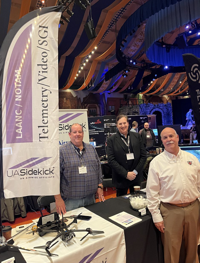 UASidekick, one of only 4 FAA-approved B4UFly App providers, will be the first to provide this free capability to first responders on its UASideKick App. Nathan Ruff, Founder of UASidekick and EVP AirWise Solutions (an affiliate company and partner on this initiative) said,“Our goal is to provide public safety professionals quick and easy access to the National Airspace System. Leveraging touchscreen maps and digitization eliminates the need to calculate lats and longs, or fill out paper-based requests, saving valuable time in emergency situations. Digital SGIs take the administrative burden off our public safety professionals so they can focus on their real mission of helping people and saving lives.”
Phil Mann, the company’s co-founder and SVP added, “We’re excited and pleased to provide public safety with the easy button for getting SGIs and being able to fly in the air space they need, when they need it.”
Trend #4 - Counter-Drone
One example, remote identification (RID) tech, which enables drones to broadcast their own “digital license plate” from the sky, exists right now. The RID requirement became effective for manufacturers in 2022 and for drone pilots in late 2023. As of March 16th, FAA enforcement grace periods have officially ended.
Aaron Pierce, co-founder and CEO of Pierce Aerospace, makers of the B1 high-performance Remote ID beacon and related R1 Remote ID airspace monitoring receiver, has racked up several years of experience working with the federal government, including the Department of Defense and Department of Homeland Security, with their RID technologies. He advises public safety professionals: "There's a learning curve with this new tech. Airspace-related tactics, techniques, and procedures that have not been a part of some agencies' operating practices must now be adopted into the broader public safety mission. However, many early adopters have already been working with Remote ID. Those early adopters appear willing to share their knowledge with other organizations to help get everyone up to speed. We also listen to end users and take their feedback to refine our products for the critical public safety mission."
For Tom Adams, Senior Director of Business Development at HighPoint Aero Technologies and co-founder of the C-UAS Hub, knowledge is key. “Drone threats and counter-drone technology and techniques continue to evolve,” he said. “The best way to prepare is to build a knowledge base about both.” In fact, Adams recently updated the paper (that he co-authored with me), Remote Identification: A Primer for Security Professionals. (For more on RID, also see our blog post Remote ID Myths: Busted!)
Mary Rupert, Analyst for C-UAS Program Management Office at the Department of Homeland Security couldn’t agree more that knowledge about UAS and C-UAS matters. She points to the public website for DHS' Cybersecurity and Infrastructure Security Agency (CISA) as a place to find information on what entities can do to buy down risk from unauthorized drone flights without having the legal authorities for advanced detection and mitigation. Another great resource, the FAA’s Public Safety and Law Enforcement Toolkit, provides multiple links to state and local regulations, a law enforcement reference card and a Drone Response Playbook.
Public Safety C-UAS Tips from CISA ● (U) Incorporate UAS into risk assessments. Assess critical assets and areas that may be most vulnerable to UAS. Identify and monitor possible launch and landing zones on or near your facility. ● (U) Reevaluate security postures and CCTV cameras and camera views to consider airborne threats. ● (U) Place "No Drone Zone" signs in areas where UAS takeoff or landing is restricted by state or local laws. ● (U) Update emergency action plans to include UAS incidents and responses. This might include evacuation protocols depending on model of drone, visible hazardous attachments, or payload size. Resource: Suspicious UAS Identification Poster and Postcard. ● (U) Establish procedures for safely handling downed UAS. Ensure that any downed UAS are rendered safe and properly handled to prevent potential harm, disruption, or destruction of evidence. ● (U) Train employees on recognizing and reporting suspicious UAS activity. Resources: Suspicious UAS Identification Poster and Postcard and Responding to Drone Calls: Guidance for Emergency Communications Centers | CISA. ● (U) Conduct exercises to test and prepare response capabilities in the case of a UAS incident. CISA’ Tabletop Exercise Packages (CTEPs), including several UAS incident scenarios, are available to download. ● (U) Consider using UAS detection technology and Remote ID receivers to enhance situational awareness of UAS activity. ○ (U) Consult legal counsel before employing detection technology as certain systems may violate federal statutes and regulations. For more information, refer to the Interagency Legal Advisory on the Application of Federal Laws to the Acquisition and Use of Technology to Detect and Mitigate Unmanned Aircraft Systems. ○ (U) Enlist UAS detection technology experts on the installation of UAS detection software and hardware within your facility as urban environments, specific placement, and altitude may impact the efficacy of the technology. Resource: ST-C-UAS Technology Guide | Homeland Security (dhs.gov). ● (U) For certain high risk SEAR events or mass gatherings, consider requesting a FAA 99.7 SSI Temporary Flight Restriction (TFR) or federal C-UAS assistance. Contact your CISA Regional Office or [email protected] for more information. ● (U) When using UAS, implement cybersecurity safeguards to reduce risk to networks and sensitive information. Resources: Cybersecurity Guidance: Chinese-Manufactured UAS | CISA and Secure Your Drone: Privacy and Data Protection Guidance | CISA. |
Trend #5 - Integrations & Partnerships
 Jason Hardy-Smith, Vice President of Products at uAvionix foot stomped this very point. He said, “Industry has to come together to offer the holistic solutions that public safety professionals need. At the DroneResponders Summit, we saw an amazing variety of products from GPS, autopilots, UAS, and DIB to ADS-B receivers and radars. Asking first responders to be experts in every component, and have the ability to develop seamless technology integrations, is unrealistic and unscalable. It is in everyone's best interest that we construct complete packaged offerings that can be readily adopted for DFR and other public safety missions.”
Nightingale Security, for example, integrates with uAvionix’s AI and computer-vision enabled Casia G ground-based detect and alert system. When Casia G detects an aircraft that might pose a risk to Nightingale Security’s Blackbird drone operation, it will trigger an avoidance maneuver to ensure the airspace stays safe. In this way, during DFR ops, Casia G allows drones to safely fly in the airspace while eliminating the need for human visual observers.
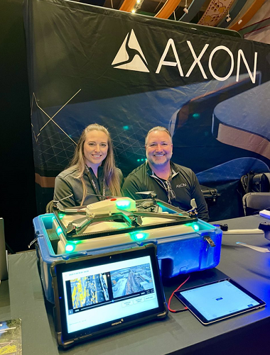 Similarly, Axon, purveyors of a broad range of public safety technologies, training and software, and Fotokite, creators of Sigma Situational Awareness System for First Responders, showcased the latter’s unique tethered drone solution together. Fotokite is seamlessly integrated into the Axon Air platform, enabling live streaming into Axon Respond, and cloud-based evidence storage on Axon Evidence. The system can enhance situational awareness with an exceptional, unobstructed perspective of any incident instantaneously, while streaming live footage. An additional value-add of this holistic solution, according to Vanessa Hregdovic, Territory Manager Southeast for Fotokite is that “Fotokite Sigma provides elevated situational awareness without the need for piloting experience.” (Watch Vern Salee of Axon on the Full Crew podcast from the Axon booth at the event).
Aerodome, creators of a next-gen air support operating system, and Mark43, the 21st century public safety platform (which includes computer aided dispatch or CAD), have linked their systems together to bring Mark43’s calls for service into the Aerodome pilot screen. This enables the drone to automatically fly to real time events right when they occur. If, for example, a call taker enters a burglary call into the Mark43 system, Aerodome’s system will immediately provide the DFR drone operator with the call type, priority level, location, call reference number and other pertinent 911 information. In addition to the usual information that populates into flight logs, all corresponding Mark43 data will appear there as well.
Rahul Sidhu, Aerodrome co-founder and CEO explained, “Our integration with Mark43 saves DFR operators critical time when responding to 911 calls with the drone. Then it also saves them even more time on the back end when they have to file their reports, which gives them the opportunity to address the next 911 call even faster.”
Advanced technologies, updated concepts of operations and a growing number of industry collaborations to provide one-stop-shop solutions for public safety continue making our neighborhoods and communities safer. This article provided just a bird’s eye view of the trends in all of those areas for those overwatching (another pun…intended) the public safety sector.
Learn more about drones in public safety at the 2024 Commercial UAV Expo.


Comments