

UK-based public safety drone company SkyBound Rescuer has completed a successful trial of a fully automated drone service aimed at enhancing public safety across bus, train, road, and tram networks. Working with Transport for West Midlands (TfWM), SkyBound Rescuer installed an automated drone station in Walsall for faster detection and resolution of transportation issues. The company hopes to build on this work to create a national network of automated drones for transportation monitoring and public safety response.
To learn more, Commercial UAV News spoke with Gemma Alcock, Founder & CEO of SkyBound Rescuer. We discussed the TfWM project, the technology behind the automated drone service, the challenges of using uncrewed systems for transportation monitoring and public safety, and what’s next for SkyBound Rescuer.
Commercial UAV News: How is this system an improvement over existing systems to monitor transport services?
Alcock: Currently, transport agencies are using CCTV cameras exclusively. Firstly, there are CCTV blackspots whereas the dynamic nature of a drone means that outdoor blackspots can be avoided by dynamically relocating the drone to a better vantage point. Secondly, when an incident occurs, the CCTV operators zoom in to collect essential details like vehicle registrations, facial recognition, etc. but when zoomed in, they can miss other activities of an evolving incident so during this trial they used their cameras to zoom in to gather the necessary information whilst the drone kept situational awareness of the entire area to monitor the surrounding activities. Lastly, when an incident is dynamic, i.e., moving and changing direction, a CCTV operator has to type in the code for the next camera along when the incident leaves the field of view of the current camera, which can cause some stages of an incident to be missed - whereas the drone was not impacted in this way.
Commercial UAV News: What kinds of individuals and teams were involved in the creation of the system, and how did you work with local governments and regulators to implement the system?
Alcock: Firstly, until 2020, SkyBound Rescuer was a research and consultancy organization for drone public safety and therefore gathered significant data and research which has informed many algorithms within the software to make informed, automated decisions. Additionally, for this particular trial and mission type, SkyBound created a 3D model of the Walsall town center and a database of transport points of interest (POIs). The 3D model was used to identify rooftops, building heights, and potential locations of high pedestrian footfall, such as highstreets, pedestrian crossings, etc. The software uses this information to create informed transit routes or airspace corridors as SkyBound refers to them, which reduce the intentional overflight of uninvolved persons. This is essential for remaining compliant with UK drone laws. With regards to the database of transport POIs, the software uses this information to determine an optimal vantage point to monitor each POI, whilst also assessing the types of risk associated to that POI, which informs its priority algorithm for conflicting requests; for example, some POIs had potential risk to life, these POIs would be prioritized over POIs with potential for threat of petty crime. Also, SkyBound's software, called the SkyBound Coordinator, includes a request form for tasking authorities to make flight requests—the database of POIs is viewable within the request form, for - in this case—Transport for West Midlands to select the desired POI for the mission. SkyBound has also integrated this software with automated drone station (ADS) technology, which makes the drone fully self-sufficient in the field—combining these technologies enables the end-to-end workflow of a mission to be automated.
Commercial UAV News: How did you develop the software?
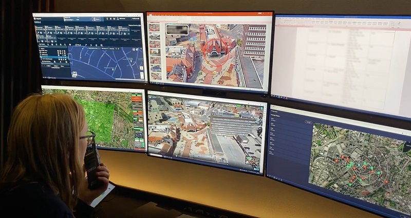
Alcock: We have a software development team— from UI/UX designers to full stack developers, to data scientists. Secondly, we have a drone operations team, who are appropriately trained remote pilots to remain safe and compliant with drone laws. We use two terms to categorize our remote pilots: remote safety pilots and Coordinators. 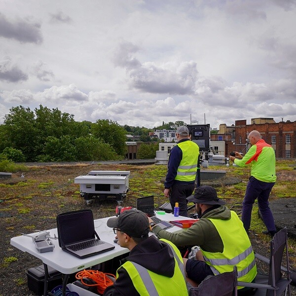 At any one point, there was a remote safety pilot on the rooftop, acting as the remote pilot for the flight - activating the launch/land, changing heading when at the vantage point, and taking over manual control when needed. The Coordinator, who is also a trained remote pilot, was remotely located in our Southampton-based control room. Their role was to create the mission plan, coordinate between the rooftop team and Transport for West Midland's CCTV control room, and monitor the real-time drone footage within the in-flight dashboard. SkyBound's in-flight dashboard has many useful features, such as every pixel in its video stream is geotagged meaning you can quickly locate activities in the real world —i.e. What3Words, lat/long, and an OS grid reference—which enables you to click on an activity in the video, locate it, mark it on a map, label it, photograph it, and timestamp it within the recorded footage - all within a click of a button; these functionalities are the responsibility of the Coordinator and therefore these remote pilots require either a background in Emergency Services, Search and Rescue, Military or similar. Notably, you can also add remote viewers within the SkyBound Coordinator, to have more eyes on the footage. During this trial, the CCTV control room were remote viewers.
Commercial UAV News: Discuss how you worked with regulators and local government for the trial.
Alcock: In terms of the regulatory piece, at this stage, we ran the trial within standard permissions under an operational authorization. The remote pilot was on the rooftop, positioned next to the ADS, and could take over manual control at any point should the automation cause safety concerns—this was only required 4 times out of 50 flights, which was only during landing, and this was due to wind gusts exceeding what they felt was safe for an automated precision landing into the ADS. Therefore, no specific CAA permission was required, besides a standard permission. In terms of local Governments, Transport for West Midlands are public sector, and was therefore the main agency we liaised with - however they sought permission from the Mayor, as well as keeping the Department for Transport within the loop of our activities together.
Commercial UAV News: What kinds of drones do you fly for these operations?
Alcock: The ADS that we used for this trial is manufactured by HeroTech8, and the drone used was a DJI Mavic 2 Enterprise Advanced. This drone was chosen for its lightweight size, which was safest when flying in a city center. We have also conducted hundreds of flights on the HeroTech8 system with no incidents, so it was our most tried and tested and reliable hardware setup.
Commercial UAV News: What have you learned from the trial so far?
Alcock: We split this trial into 2x 1-week operations, with a 2-week interval in between in order to capture learning and improve the service for the second week. We learned and improved a lot, but the 2 key areas were: connectivity and time on task. With regards to connectivity, in the first week we were using an EE 4G SIM card in a MicroTik for connectivity but there was unfortunately a mobile network outage on 1 of the days and we struggled with bandwidth on most days. 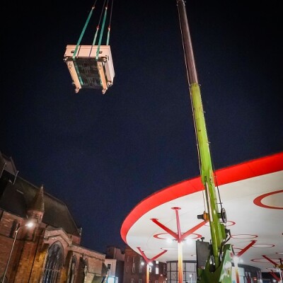 In fact, we log successful and unsuccessful outcomes after each flight, and in the first week 35 unsuccessful outcomes were linked to connectivity (85% of the unsuccessful outcomes in week 1). We procured and tested StarLink for the second week, which was a significant improvement. We only had 3 unsuccessful outcomes linked to connectivity in the second week. With regards to time on task, due to our methodology of airspace corridors that transit along rooftops, the drone does not fly in a direct line to the vantage point - in the first week, our time on task was an average of 5 minutes 29 seconds. We refined the airspace corridor algorithms by reducing the number of waypoints and the airspace corridor distances, which sped up response and allowed for more time on task. We also assessed flight data to understand what is the lowest battery % the drone can stay on scene for before transiting back and to land at the lowest safe battery %. By understanding this for each mission, we could make informed decisions about when to return which also allowed for the most out of 1 drone battery. This increased our average time on task to 10 minutes 1 second per flight.
Commercial UAV News: Are you working on enhancements or changes?
Alcock: In general from week 1 to week 2, we increased our number of successful outcomes by 51, decreased our number of unsuccessful outcomes by 34, we increased the number of activities being marked in the real-time footage by 37—meaning that our Coordinators were observing more activities, because we automated more features to reduce their spans of control and increase their awareness—and we increased the total time monitoring the transport points of interest by 2 hours 31 minutes.
Commercial UAV News: I understand that SkyBound Rescuer plans to expand the service nationwide. What needs to happen to make that a reality?
Alcock: We have created a GIS map that assesses almost 1 hundred databases to locate areas that would experience high demands for our automated drone service for public safety and transport. The team is in the process of conducting site surveys for each of the highest scoring locations to begin our ambitious rollout plans. Achieving permission for BVLOS operations will also enable a more rapid rollout because it will remove the need for onsite personnel, making a rollout more cost effective and faster. We have a step-by-step process for achieving multiple Operational Safety Cases that we hope will enable us to reach BVLOS with electronic mitigation by the end of the year. We are also preparing for our third investment round to fund the first rollout phase.


Comments