

February 24th marked yet another big step towards the successful integration of manned and unmanned aircraft in controlled airspace. This time the breakthrough came from our neighbor to the North, Canada, where Ventus Geospatial, a Canadian company using an Aeryon Skyranger performed a Beyond Visual Line of Sight (BVLOS) flight at the Foremost UAS Range in Alberta.
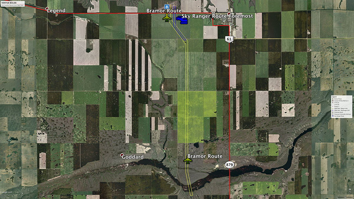
Transport Canada has followed closely developments in the US by the FAA in regulating UAV flights in uncontrolled airspace under Part 107 and special waivers, but now the pressure from the various stakeholders is as strong in Canada as it is in the US. This first flight lays the foundation for how small UAS operators can legally and safely fly BVLOS within Canada and around the globe. For more about drone regulation in Canada, read this interview with Matthew Johnson.The Foremost UAS Range was created in 2014 when the Canadian Centre for Unmanned Vehicle Systems (CCUVS) was granted all necessary approvals to manage a permanent area of Restricted Airspace for testing Unmanned Aircraft Systems in Southeast Alberta. The Range offers 700 square nautical miles of airspace designated for up to 18,000 feet above sea level, and is ideal for training, research and development and is open to both Canadian and international companies.This airspace designation is the first of its kind in Canada and will be available for UAS training, research and development for civil and commercial purposes. The designated airspace is particularly well suited for BVLOS flights and CCUVS has the ability to close the airspace when approved flight operations are taking place, thereby significantly reducing any safety risks.With this environment in place, three Canadian companies set out to prove that BVLOS flights could be performed in a safe manner. Aeryon Labs Inc, provided the Skyranger UAV Platform to the operator, Ventus Geospatial Inc., which in turned used Canadian Unmanned Inc., for all training and safety consulting during the test flights.The test flights also involved a C-Astral Bramor fixed wing platform which flew for 36 minutes and 13.7 miles while the Sky Ranger flight was 12 minutes and 2.8 miles. At the farthest point away from the operator, the Skyranger was at 1.4 miles and the Bramor at 6.9 miles respectively before returning safely.We had the opportunity to ask Stephen P. Myshak, CEO of Ventus Geospatial, a few questions regarding the test flight. Juan What’s the relationship between Aeryon Labs and Ventus Geospatial?Stephen Aeryon was the provider of our first UAV 5 years ago. We have worked with them many times to collaborate on software, hardware, and operations. We have a close and co-operative relationship, both companies trying to move the industry forward. What technology was used to keep track of the flight path?Live video and the heads up display. We also used a chase vehicle as a back up to monitor the flight from a county road. I’m particularly interested in the detect-and-avoid technology used, if any.Not in these flights but the next test will use ADS-B. What kind of safety measures were in the aircraft to make it land/return in case of emergency?They both have a number of safety features in case of many scenarios. Please see the manufacturer’s websites for more details. www.c-astral.com and www.aeryon.com What makes this flight relevant or newsworthy, apart from being the first BVLOS in Canada?Well, it was the first in Canada and it opens the door for Transport Canada to start to get data from the flights and this will lead to regulations so qualified users can start to operate in non restricted airspace to do pipeline, power line, and large area mapping in Canada. What was the involvement of Transport Canada?Lots of involvement with Transport Canada as the regulator. The process started about 10 years ago. Our involvement and discussion started 18 months ago for a license to fly BVLOS. What are the next steps?The next steps are a sense-and-avoid system and test in the Foremost test area, then a test outside the test area that should lead to a license to fly commercially in class G airspace. According to the FAA’s more recent forecast, the number of drones will reach 3.6 million units by 2021. As of today, the commercial applications for UAV’s are limited to line of sight flights and therefore commercial applications are also limited. The same FAA forecast report indicates that the agency expects over 400,000 drones will be used by business by the same year. These predictions are based on current legislation that limits BVLOS flights.With the approval and eventual regulation of BVLOS flights, the FAA is forecasting that the numbers for commercial drones will more than triple to over 1.6 million units. It is obvious that legislation for BVLOS authorization is an imperative and we are glad to see more and more efforts, inside and outside the USA, to convince the regulators that this technology can be integrated to the manned airspace in a safe and responsible manner.

.jpg.small.400x400.jpg)


Comments