
News about Insitu, FireWhat and Esri joining forces to fight fire was a big deal, not just because of what this partnership could mean for these companies, but because of what it will mean for fire incident commanders. Fighting wildfires in a totally new manner with technology is an exciting concept, and it’s one that people who have been in these kinds of emergency situations are especially well suited to figure out.
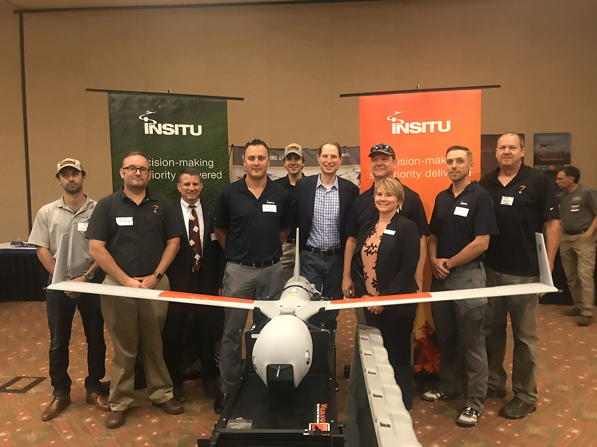
“I was a career fireman who left the industry to solve problems I faced on a daily basis,” Sam Lanier, CEO of FireWhat, told Commercial UAV News. “One of the biggest problems I saw was the lack of technology adoption, when every firefighter carried a cell phone in their pocket. We should be enabling firefighters to contribute data from the field both for health and safety and helping make more informed decisions. Our team is constantly looking at how we can provide real world solutions to real world problems.”Many of those real world problems are associated with not being able to gather the right kind of data in a timely or effective manner, which led to their partnership with Esri. FireWhat was an early adopter of the ArcGIS Online Platform and contributed to the Esri Wildfire Public Information map with data from their website. The kind of difference this technology can make when it comes to gathering data and turning that data into actionable information has been well established, but being able to do so in emergency situations is of critical importance for very different reasons.In 2014, Firewhat introduced the use of ArcGIS Collector to CalFire on the Boles Fire to conduct Real Time Damage Assessment. In 2015, they forged a strategic alliance with the Executive Team of Esri that has helped them secure partnerships with HP and now Insitu.“As part of our work with Insitu, for the first time ever, real-time imagery is being piped into our GISDirect FireLine Data Analytics system,” Lanier explained. “The system allows us to control the turret sensor payload of the drone, and rapidly digest the imagery, to post process the data on a map. We can then deliver that info to the palm of a firefighter’s hand, in near real-time. This allows us to rapidly deploy the system with Esri Enterprise client settings.”That rapid deployment system represents a major shift in terms of the kind of information officials are able to utilize and reference in these emergency situations. Currently, the US government uses a system called NIROPS, but the information this system gathers can be outdated by the time it’s viewed by officials on the ground. By then, the situation with a wildfire might have completely changed.Additionally, the current procedures when it comes to flying through smoke are extremely limited because the risk to the human pilots is so great. When a fire has an inversion layer, all aircraft are grounded. Utilizing a drone to operate in these conditions mean that officials will not need to make decisions based on information that is 12-18 hours old.What kind of a difference can this technology make on a practical level though? That’s something you can see and hear for yourself.https://youtu.be/9C5YJZTeMuUWhen firefighters are making decisions based on information that is outdated, those firefighters and the public at large are being put at risk. Anytime officials have to send firefighters into areas where they have no intelligence and cannot tell where those firefighters are located, the danger to everyone involved is considerable. Accurate information can and does make all the difference in the world.Firefighters still face hurdles when it comes to adoption, but the ability to plan for events represents a change to emergency response paradigms, since officials can be proactive instead of simply reactionary. They can create geo-fences and geo-events, and also enable real-time decisions making. All of these efforts will save time, money, and even property.The kind of difference the technology can make will be on display at a test flight of Insitu’s ScanEagle UAS and FireWhat’s custom GIS capability that is set to take place on August 31st. Attendees will be able to get a great sense of what kind of difference this technology can make.As Lanier mentioned though, adoption can represent a major challenge for many emergency response departments and even individual users, and it’s why test flights represent a great place to see and understand the difference the technology can make. However, the hurricane relief efforts in response to Hurricane Harvey might provide an even more poignant showcase of the technology.As this article was being written, Lanier and a portion of the FireWhat UAV-GIS team were deployed to Corpus Christie, Texas. The team will be aiding in the response and recovery efforts by providing real time GIS for rescuers, managers, and officials. The extensive wildfire mapping experience is what has given this team the ability to deploy on larger disasters like Hurricane Harvey. The workflows are very similar, yet the frequency is not as common as the annual wildfire season in the west. This technology is proving itself to be very effective for all types of natural disasters, and it’s the reason Lanier has some simple advice for anyone looking to approach integrating the technology.“Just do it!!” he concluded. “We are taking every possible precaution to test, retest, break, and prove this technology. This has been a dream of mine since 2003 on the wildfire siege in SoCal. And since 1994 when the Fire on Storm King Mountain took the lives of 14 firefighters. This technology allows us to do our jobs safer and more effectively.”Subscribe
The information you submit will be stored and used to communicate with you about your interest in Commercial UAV News. To understand more about how we use and store information, please refer to our privacy policy.
August 30, 2017
Drone Technology Helps Fight Wildfires in a Totally New Way

Want more stories like this? Subscribe today!
.jpg.small.400x400.jpg)

Jeremiah Karpowicz is the former Editorial Director of Commercial UAV News. He has spent over a decade cultivating communities of all different types, both in-person and online. He has created articles, videos, newsletters, ebooks and plenty more for these communities as a contributor and editor. He has also shaped and defined various conference programs. Today, he is focused on defining what it means to take the engagement that happens in both the physical and digital worlds to the next level. You can get in touch with him on LinkedIn.
Featured Report
Featured Authors More Authors ›

Featured Authors


Newsletter Signup
Our Events


Our Events
September 1-3, 2026 • Las Vegas
February 23-25, 2027 • Salt Lake City
Comments