

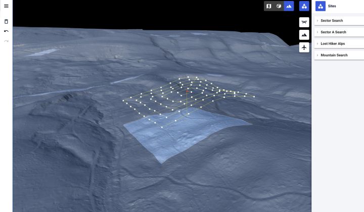
Last month, AEE Technology and Drone Harmony announced a new product and distribution partnership to incorporate AEE’s first responder UAS into Drone Harmony’s Search and Rescue (S&R) Autonomous Flight System Software. This means Drone Harmony will now support the full complement of AEE’s commercial aircraft as well as several other leading manufacturers of UAV/Drone technology around the world for S&R missions, enabling drone pilots to execute an Autonomous Search Pattern rapidly with integrated topography capability.
To allow public safety teams around the globe to quickly and efficiently execute UAV searches with a touch of button, Drone Harmony’s software now features preselected search patterns, including expanding squares, sector searches, and track lines with the ability to add Terrain Aware automation. The software will automatically program the flight by selecting the search area on a map and the type of search pattern. Additionally, pilots can concentrate on the video feed (Thermal or RGB) if the Terrain Aware option is active.
“We are excited to see how our technology can help to save lives,” said David Adjiashvili, founder of Drone Harmony. “Drone Harmony has years of experience with autonomous drone flight and integrated Terrain Aware flights, and seeing this technology being put to work in S&R is incredible.”
Initially designed for telecommunications, industrial inspection, terrain mapping and surveying, and power lines and linear infrastructure, Drone Harmony’s software solutions are ready for enterprise-grade data acquisition. Recently, Commercial UAV News wrote about the company’s partnership with Phase One, demonstrating how Drone Harmony’s cloud platform helps in different situations, including how Bryn Le Rue, a Florida firefighter, used the platform for S&R missions in large areas of land, water, and complex industrial sites.
“Currently in Florida or the US not many fire departments or S&R agencies are using inspection software for this kind of work,” stated Le Rue in 2021. “Some use waypoint placing software to set their own waypoints. But this is a long process and even more so one tries to achieve a consistent search pattern. Some are mapping software such as Pix4D, whilst the majority still fly manually. In contrast, a search area using Drone Harmony can be planned and flown within minutes.”
This certainly opened the doors for Drone Harmony to explore its technology’s potential for the S&R and disaster response market. Compared to traditional methods, or flying a drone manually, Le Rue claims Drone Harmony’s software provides S&R missions with faster, safer, and more accurate search patterns, even in areas with limited or no cell reception. It also enables the possibility to prepare possible search areas from previous missions.
“I used to fly manually on missions, sometimes using Litchi, until I saw a blog post on Drone Harmony inspections,” Le Rude added. “I immediately saw the opportunity to do the same kind of planned missions for S&R or disaster response to gain as accurate and as much information as possible. Prior to using Drone Harmony missions were not as precise. Search areas could easily be missed, but with the ability to set accurate flight plans with Drone Harmony, this is a thing of the past.”
As the manufacturer of the Mach 6 and Mach 4 drones, AEE will work as a distribution partner of Drone Harmony solutions for S&R, with pricing reflecting public safety agency teams or drone fleet size and the complexity and scale of topographic data used.


Comments