


Contributed by Pro4Aerials LLC
More drone service companies are running mixed fleets. Some of that is due to import rules pushing U.S. operators to add or switch aircraft. Some of it is plain business sense, as the best aircraft for a 40-acre survey is rarely the best one for a tight roof job.
We run real estate, roof inspection and mapping work in Florida, and the lesson from moving between autopilots is simple: The aircraft changes, but the plan should not. If your planning is tied to one maker's app, every new airframe means re-learning the job. If your planning is built on numbers and standard files, a new aircraft is a half-day of setup.
Here is how we keep the plan portable.
1. Start from the detail you need, not the height you usually fly
Every mapping and inspection job has a target: how much ground each pixel covers (ground sample distance, or GSD). Pick that first, then work out the height for the camera you are flying today.
For a common 12 MP camera (about 82° diagonal field of view) pointing straight down, the numbers work out roughly like this:
- 100 ft above takeoff: one photo covers about 139 × 104 ft, about 0.4 in per pixel
- 200 ft: about 279 × 209 ft, about 0.8 in per pixel
- 300 ft: about 418 × 313 ft, about 1.2 in per pixel
A 20 MP, larger-sensor camera gets about 0.66 in per pixel at 200 ft. So if a client needs 0.8 in per pixel, the 20 MP aircraft can fly higher, cover more ground per photo, and finish faster for the same detail. That is the kind of trade you can only see when the plan is written in detail-per-pixel, not "we always fly 200 ft."
For roof work, we aim for about 0.2 in per pixel on the angled photos of each roof face, because that is where shingle and flashing problems show. Close-ups of test squares, vents, and gutters are still flown by hand.
2. Set overlap by the surface, then let the math place the photos
Starting values we use for front/side overlap:
- Land and property maps: 80/70 percent
- Construction sites and stockpiles: 85/80 percent
- Crops, fields and 3D models of buildings: 85/80 percent (buildings also get angled orbits)
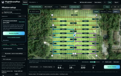
Raise overlap over trees, water, sand and plain fields, where processing software struggles to match photos. Once height and overlap are fixed, spacing is simple: photo spacing along a pass is the photo's length times (1 − front overlap), and the distance between passes is the photo's width times (1 − side overlap). At 200 ft with 80/70 on the 12 MP camera, that is a photo about every 42 feet and passes about 84 feet apart. Those numbers carry to any aircraft with the same camera geometry, whoever made it.
Fly a little past the edges of the area, keep one height for the whole map, and add ground control points or PPK/RTK when positions matter. Consumer GPS is typically within about three to 15 ft, which is fine for a marketing map and not fine for a volume report.
3. Do the airspace and weather check for the spot, not the city
Before any mission file exists, check the exact location:
- Airspace class at ground level. Uncontrolled (Class G) airspace needs no authorization up to 400 ft above ground under Part 107. Controlled airspace near airports needs authorization, and the FAA's facility maps give the maximum height that can be approved automatically through LAANC; in some grid squares that number is 0 ft, which means a manual request through FAA DroneZone and a lot more lead time.
- Temporary flight restrictions and NOTAMs on the day of the flight, not the day you quoted the job.
- Hourly weather for the flight window: sustained wind, gusts, rain chance, and thunderstorms. In Florida, the afternoon storm cell is the usual reason a morning-quoted job gets moved.
None of this depends on the aircraft brand, which is the point: it belongs in your planning step, not inside one flight app.
4. Move the mission with standard files, and know where they differ
Most waypoint-capable aircraft can take a mission from at least one standard file:
- .plan and .waypoints (MAVLink) for ArduPilot and PX4 aircraft
- KMZ waypoint files for DJI controllers
- KML, GeoJSON and GPX for other brands, GIS tools and client maps
The file moves the geometry. It does not move everything. These are the items we re-check every time a mission goes to a different aircraft:
- Height reference. Is the number above takeoff, above sea level, or above terrain? A mission written above takeoff and read as above sea level can be hundreds of feet off. Check the first waypoint's height in the receiving app before you fly.
- Camera triggering. Some formats carry a photo action at each point; others expect you to set distance- or time-based triggering on the vehicle.
- Heading and gimbal pitch. Conventions differ between formats and autopilots. A façade or roof-face pass with the camera pointing the wrong way is a wasted flight.
- Speed and turn behavior. Stop-and-shoot versus flying through points changes photo sharpness and battery time.
- Return height and failsafes. These live on the aircraft. Set return-to-launch height above the tallest obstacle on the site, and set the lost-link and low-battery actions before the first mission on a new airframe.
- Waypoint limits. Some controllers cap the number of points per mission; large maps may need to be split.
5. Prove the new aircraft on a small known job
When we add an aircraft, the first mission is a job we have already flown: a small open lot with known results. Same plan, same height, same overlap. If the outputs match, the plan is portable and the aircraft is ready for paying work. If they don't, the difference is almost always one of the items in the list above.
The Takeaway
Brand loyalty is a poor planning system. Write your jobs in the numbers that matter to the client (detail per pixel, overlap, safe heights, a dated airspace and weather check), keep missions in standard files, and treat each new aircraft as a short setup checklist instead of a new workflow. Your fleet can change as fast as the market does, and your jobs keep coming out the same.
About the Author
 Marc is a Part 107 remote pilot and a licensed commercial fixed-wing pilot with an instrument (IFR) rating for over 30 years. He is an entrepreneur and visionary with a background in several industries, including IT and aviation. He co-owns Pro4Aerials LLC, a Florida drone services company, with his business and life partner, Cindy, and together they make FlightDronePlan, a browser-based mission planner for many drone brands.












Comments