

When a local government decides it’s time to accurately capture assets around its jurisdiction to create digital tools to help both the community’s workers as well as the general public, it’s easy to assume that it will require massive investment, especially when the project calls for data to be collected via UAV. Many of these projects fail to get off the ground due to attempting to do too much too soon, looking for massive expenditures that are ultimately not approved by town councils and/or the general public in a vote. In one borough in London, however, they managed to work around those barriers by starting with more accessible technology.
When Samuel Tizzard, head of GIS and data manager at the London Borough of Harrow, proposed building a digital twin of the entire borough, he did not walk into his manager's office with a detailed business case or a request for significant capital investment. Instead, he asked to spend about £1,000 on a consumer drone.
"There was no strong business case put together or anything like that," Tizzard told Commercial UAV News in a recent conversation. "We built up quite a bit of credibility through other projects for saving and making money in different areas, doing innovative things like our own Street View and other tools like that. So I said to my boss, ‘Actually, we could probably start with a hobby-level drone.’"
That drone is now at the center of a growing 3D mapping program that has already saved the council £12,000 on a single roof survey, generated measurable public engagement on park pages, and opened new approaches to persistent challenges like illegal waste dumping.

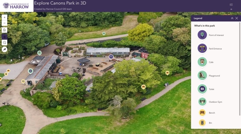
The borough's digital twin is built on a layered strategy. Harrow commissioned a low-resolution mesh of the entire borough from aerial imagery provider Bluesky, creating a base that provides context across the whole area. Against that base, Tizzard's team drops in high-detail drone scans in areas where they’ve deemed precision matters most, such as parks, recreational centers, libraries, arts venues, and historic buildings.
"There are areas where we can get away with using the low-res stuff, just to provide a bit of context. We know there's a big building here, we know there's a shopping center here, we know there's a park here. And there are areas that people are interested in or want to see in higher detail for a number of reasons," Tizzard explained. "Roof condition surveys as well, when we capture 3D sites like our libraries, our art centers, stuff like that, they're more what we're interested in as a council."
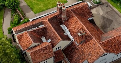
The approach keeps costs down while delivering detail in the more important areas. At Headstone Manor and Museum, a Grade I listed manor house dating to 1310, UAV-based roof surveys replaced traditional scaffolding and manual inspections entirely, saving £12,000 on that project alone, according to the town
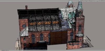
Of course, capturing the data is only part of the issue. As the town found out, processing the drone imagery presented a different kind of challenge. Tizzard initially tried running mesh models through desktop photogrammetry software, but that was untenable running on the town’s hardware. Eventually, their solution came from a team member who pointed to Esri's Site Scan for ArcGIS, a cloud-based platform that handles processing without requiring local servers or ongoing IT infrastructure.
"It's really, really good,” Tizzard said. “There is no server hosting, no maintenance, no ongoing cost for any of that nonsense. You just chuck images up into it and click go."
So, with the data both collected and processed, what are they actually doing with the data?
One of the program's more visible applications is its use in promoting public green space. Interactive 3D models of the borough's parks are being embedded in the council website as part of the Healthier Harrow program, which aims to reduce health inequalities and encourage more active lifestyles. The models show playground locations, cafes, toilet facilities, entrances, and benches, giving residents a more informative view of what a park offers before they visit. And the early engagement numbers are encouraging.
"There have been about 920 people who have gone to our park website pages in the last 30 days," Tizzard noted. "And of those, about 302 had actually clicked through to look at the 3D parks. So about a third of the people who looked at those parks on our website decided they were going to look at the 3D models, which is pretty high engagement, I think, considering we've not actually told anybody we've done it."
Harrow is also piloting the use of 3D drone models to support its response to fly-tipping — the illegal dumping of waste — at known hotspot locations. The current process relies on 2D maps to decide where to position cameras, signage, and fencing, but Tizzard sees 3D spatial context as a meaningful upgrade.
"If you were to try and do that in a 3D world, it's probably more accurate and appropriate for what you're trying to do, as well as being able to access and see things that you couldn't from a 2D map or from the street necessarily."
Tizzard is candid about where the program stands today.
"I'd call it an infant digital twin," he said. "It's very junior in the sense that we are updating it with 3D meshes, and we are dropping BIM models into it occasionally when we get them from developers."
The longer-term vision includes integrating real-time data layers — traffic, weather, transit — and eventually building predictive modeling capabilities that could simulate the downstream effects of new developments on local services and infrastructure.
The main constraint right now is actually mostly to do with staff capacity. The drone currently flies once or twice a month around existing workloads, and expanding that would mean training additional pilots. Tizzard says they are actively working to address this barrier before demand outpaces the team's ability to respond.
For other local authorities considering a similar path, his advice is straightforward: Check your airspace first, resist the temptation to start with expensive enterprise hardware, and make sure at least one service area is genuinely engaged before you buy anything.
"Start small," he told CUAV News. "Test your ideas first and use smaller drones. If you can get away with a cheap, lightweight drone, then you're saving yourself hassle, time, and money."
A previous attempt by another Harrow team illustrated the risk of the opposite approach: A proposal centered on a £13,000 enterprise drone with a base station was shut down before it started, lacking the business case to justify the investment. Tizzard's program, which began with a fraction of that budget and a willingness to prove value incrementally, has taken a different trajectory and projects for continued growth looking forward.


Comments