

Every commercial sector and industrial segment in the world is defining what effects uncrewed vehicles will have in their daily operations and what actions are necessary to implement these innovations. From public safety to search and rescue to nuclear plant inspections, thousands of public and private enterprises are discovering, almost daily, that there are operations in their workflows that can be improved by introducing these uncrewed marvels.
One of the sectors that has seen a radical transformation due to the introduction of uncrewed aerial vehicles (UAVs) is telecommunications. The reason is simple. Today, most if not all expansion in a telecommunications network is happening on the wireless side, and that involves towers, lots of towers.
Now that cellular communications have been around for over three decades as a mainstream technology, towers are beginning to show signs of decay, and some are in dire need of upgrade and maintenance. This issue created the first real application for UAVs in telcos: tower inspections.
But the applications did not stop there. Amazingly enough, the popularization of drones and the potential for flights beyond visual line of sight (BVLOS) have created a need for densification of the network, and that has spurred a need for ultra-precise mapping of future tower sites, a perfect task for a mapping drone.
To better understand how all these issues happening simultaneously are making the utilization of drones a must in an established industry, we reached out to Luis Ascanio, CEO and founder of DronePixel, a Venezuelan-based drone company that just received a contract to inspect old towers and a potential engagement for the expansion of the 5G network in the country.
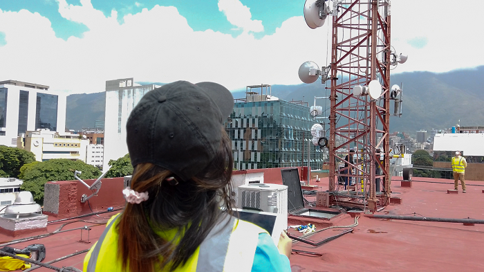
“There are two radically different sides to the issue of cellular towers, urban and rural,” Luis said emphatically. “In urban areas, towers are located on top of buildings, and inspections are somewhat routine with a couple of operators spending about 30 minutes to complete the flight and gather the data. The office work to turn that data into valuable information takes another day, and then we deliver our findings to the telecom company.”
But DronePixel was not founded with the telecom industry in mind. It started with more modest photogrammetry projects in areas where precision imagery and 3D models were necessary.
“It’s funny how we have a clear path forward with mapping and engineering when the 2020 pandemic hit,” said Luis reflectively. “We lost a lot of business and many employees. We needed to identify the most lucrative industry in the country to focus entirely on the ability to satisfy the needs of one particular client. Expansion was out of the question, so we selected telecommunications as the sector that the country needed the most to survive the pandemic.”
The decision proved to be right, and the dependency of the population on good, reliable wireless communications during the COVID-19 pandemic forced the three service providers to invest heavily in the maintenance of existing towers and construction of new infrastructure that would provide service to more people.
“We set up to prove to the telco operators that using a drone for inspections and the writing of the report would take hours instead of days or weeks. We convinced them that this was the way to go at a time when conventional inspectors were sick or incapacitated by the virus and towers were failing all over the country,” said Luis. “We performed many inspections and found many issues that were resolved to maintain the integrity of the network.”
The operators soon realized that the uncrewed solution was ideal, not only for inspections, but to accelerate the rate of growth of the network by mapping potential sites for new towers faster.
“Once the operators saw the advantages of using drones, the floodgates opened for new opportunities such as mapping of new sites and spectrum analysis,” Luis said with enthusiasm. “We found a spectrum analyzer that was light enough to be placed aboard one of our drones and began showing the operators the weak areas in the network; this created new opportunities for mapping of new sites, and the business kept growing.”
Mapping of new sites in an urban setting was relatively easy, but the rural areas proved to be tougher for a young and inexperienced company. In order to understand the complexities and challenges of finding adequate sites for wireless towers, we reached out to Mauro Iafrate, a Geodetic Engineer and 15-year veteran of telecom network expansion.
“Access to high ground in rural areas is definitely a challenge,” said Mauro firmly. “As soon as I heard of the use of drones for identifying and mapping of these sites, I thought ‘perfect!’ that’s the answer. Creating a 3D view of a hill in the middle of nowhere is not easy using conventional methods, but from the air you can not only map the very top but also the adjacent areas including potential sources of services to feed the structure once it’s built.”
In a rare case of an emerging technology creating opportunities that arose from its own introduction, telecom operators are now studying the density requirements that autonomous vehicles will require to operate safely. These numbers are showing that there’s a need to almost double the number of towers throughout the service area.
“In an incredible turn of events, we were told by our customers that in order to allow drones to safely fly autonomously in the future, the network needs to grow exponentially over the next few years,” Luis said with a smile. “Apparently, there are conversations between the civil aviation authority and the telecom operators to define what densification is acceptable to guarantee 5G reliability thus allowing drones and autonomous ground vehicles to operate safely. This has created a brand-new revenue stream to our current operations.”
Knowing that the future of telecommunications is wireless and taking into account the key role that reliability of the 5G network will play in the deployment of UAVs and air taxis throughout the world, an expansion of the network to guarantee such dependability is guaranteed. This will create huge business opportunities for all drone operators looking for new revenue areas and expansion of their current operations.

.jpg.small.400x400.jpg)


Comments