Being able to “do more with less” is a concept that has always been top of mind for survey professionals, and it’s part of the reason so many are looking to work through the logistics of aerial surveying with a drone. UAVs have made a real impact in terms of making a given task cheaper, faster or safer for surveyors, all of which mean they’re able to be that much more efficient. It’s a concept that could become incredibly important if the demand for this type of survey work increases in the near future. And there are numerous indicators that it will.
“
Grow your business without hiring” is an article from the Aerotas team, and it lays out how this kind of efficiency can be achieved by using drone technology, and why it will soon be essential to do so. The piece explains how drone technology can allow someone to get 5x the amount of work done, reduce the resources that are needed for a given project and attract an entirely new type of person for positions that do need to be staffed.
Being able to “do more with less” is a luxury that is quickly turning into a necessity for surveyors, and that concept is something we wanted to further explore. To find out why it’s going to be so important for survey professionals in 2018, we connected with Daniel Katz, Co-founder at Aerotas. We discussed why he thinks there’s going to be so much job opportunity next year, what impact the
Aerotas Mapping System will have on anyone who needs to be that much more efficient, how young people interested in the profession should be approaching getting into it, and plenty more.
Jeremiah Karpowicz: You mentioned that surveyors are struggling to keep up with an unprecedented workload in every state, but what kind of work is this? Are these jobs distinct or different than the work that was happening in the pre-2008 environment? Daniel Katz: It's a pretty eclectic mix of work -- the work that was bottled up since 2008 has come uncorked. There are development projects that started before 2008 then stalled after, and are now being restarted and require survey for design. There are new development projects launched by investors looking for places to put growing earnings, that require survey for planning. There are properties changing hands as the economy becomes more liquid, which require survey for land title transfer. There is a ton of new construction happening that requires all parts of survey: existing conditions, topography for planning and design, grade-checking, volumetrics for verifying earth works subcontractors, as-built for post-construction, and inventory for handover. And nearly every one of these types of survey can be done faster, cheaper, and more profitably with the right drone workflow.
What are some of the indicators you’ve seen that tell you 2018 is primed to be even bigger in terms of these job opportunities? The most important piece of evidence is what we're hearing from our land survey clients: they are signing even more contracts today for work to be done in 2018. Broad economic indicators reinforce this, with interest rates remaining low and an increasingly dynamic workforce moving to new and rapidly growing population centers. What's remarkable is how consistent this story is in very different parts of the country. We have a unique perspective on the industry given our nationwide footprint. Of course there are exceptions, but by and large we're hearing the same story in every geographic part of the country: the 2017 construction season was (and continues to be) maddeningly busy, and our clients say their clients indicate that next year will see this trend intensify.
 If that’s the case, then being able to “do more with less” is practically a necessity, but how do you position that concept with surveyors who don’t think that’s possible? I imagine there are professionals who believe they’re already being as efficient as they can be, and if they had anything less they wouldn’t be able to do their job.
You are highlighting a definite challenge: helping survey business owners understand how to strategically do "more with less."
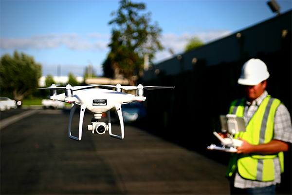
First, it's important to set some basic expectations: a drone is never going go replace a surveyor fully, nor eliminate the need for surveyors to put their boots on the ground on a project site. What it does, however, is dramatically reduce the amount of time they need to be on-site -- that's where that 90% time savings comes in.
There is definitely some "too good to be true" bias we face when introducing surveyors to our system, which usually boils down to two concerns: accuracy and total workload.
- Accuracy. The hype-storm of the drone industry led to some over-ambitious accuracy claims, complicated by drone makers not understanding how surveyors undersatnd accuracy. We have done exhaustive research and testing to support our system's all-in accuracy as better than 0.1' vertical -- which is industry-best. This accuracy comes from comprehensive field testing and statistical analysis based on ASPRS Positional Accuracy Standards, not just ground sampling distance nor selective spot-checks.
- Workload: the 90% field time savings is real, and comes from being able to substitute a quick drone flight for the time-intensive process of walking a grid over an entire site. However, it still requires office-work to produce their final survey, and this is where many surveyors get burned, spending 2-3x longer in the office wrestling with image-stitching and CAD than they would have conventionally. Our system solves for this, by implementing a complete workflow that is surveyor-specific and side-steps the most time-intensive components. Our clients regularly report that they spend the same amount of time in the office as if they had done the same project conventionally. This usually equates to a total project savings of 50-65% man-hours.
Ultimately it all comes down to workflow. The drone is simply a tool that enables a new workflow -- the drone may be the exciting part, but the right workflow is what makes it a profitable and effective tool.
In terms of the industry needing to evolve, some of that plays into the concept of using a drone as a tool in a hybrid workflow, doesn’t it? Seems like that can be an especially interesting challenge for anyone who wants to pursue this as a profession. Land surveying is a challenging profession! That's what makes it exciting. Surveyors have historically been at the forefront of new technologies: metric cameras, GPS, robotic total stations, laser scanning/LiDAR, and now drones. Having a variety of tools to choose from project-by-project has always been part of the profession, so in that regard there is nothing new about a drone. What is new, however, is learning how to use multiple tools on one job, as our clients do. With our coaching, our clients rely on the drone on parts of a project site where it is a time-saver, and rely on ground collection for other parts. The initial instinct is often that they need to just use one tool for the entire project, but with the right workflow, it's easy to merge data from different tools together, thereby getting the best of all worlds.
Another huge benefit of the Aerotas Mapping System is that compared to most surveyor tools, it's incredibly easy to use. Survey-grade GPS and total stations are very specialized and complex tools, that require a great deal of experience to use effectively. By contrast, our drone system requires minimal specific previous experience. We see a lot of businesses misstep by thinking they need to hire a specialized "drone person" to run their new drone program, but the truth is we can take anyone -- from young chainman to the head of the survey department -- and quickly make them a proficient drone operator.
It will be exciting to see how drones spur the future growth of the survey industry as a whole, but what do some of these younger people need to know about in terms of making a career in this industry? They need to do much more than simply buy a professional-grade drone, don’t they?The first thing to understand for potential new "drone surveyors" is that the "surveyor" part is much more important than the "drone" part. Surveying is a rich, complex, and fascinating discipline, which is today being made even more exciting by the incorporation of drone technology. A number of survey programs at universities are starting to include drone basics into their curricula, so they can expect to be getting their hands on the technology early on, but most of their focus is best spent on learning the basics of surveying.
Similar to the misconception that survey firms need to hire a specialized "drone operator" for their drone program, another misconception is the belief that they need to buy a drone that is advertised as "professional-grade"... and expensive. Drones have quickly become commoditized, and we're producing industry-best accuracy (better than 0.1' vertical) with inexpensive "pro-sumer" drone. The drone doesn't need to be "professional-grade," but the operator does! We keep seeing over and over again that high-quality, proven training and ongoing support on best practices for safety and accuracy is essential to a profitable drone survey program.
What would you say to anyone who doesn’t think 2018 will see this kind of growth in terms of job opportunities? And that perhaps they won’t have a need to “do more with less”, and they can move forward just fine with their traditional approach? What we have been talking about here are broad themes, which may not apply to absolutely every surveyor, business, or geographic area. There are certainly parts of the country that are
not experiencing huge growth, but I can attest to that being the minority. I always encourage business owners in these lower-growth areas to think about how they can make their business healthier and more viable even despite the lack of growth. By including high-resolution aerial orthophotos as base-maps to their surveys, they can charge more money for each survey. By using our drone system to save time on each project, they can use the extra time to explore new potential customer bases or product offerings. A drone program can be a potent marketing tool to help spur new business in their area.
Compared to other survey tools,
our drone system is quite inexpensive, so we have several clients who have purchased it as an investment to try to grow their business in new ways, and it has paid off!
Read the full article from the Aerotas team here. 


Comments