

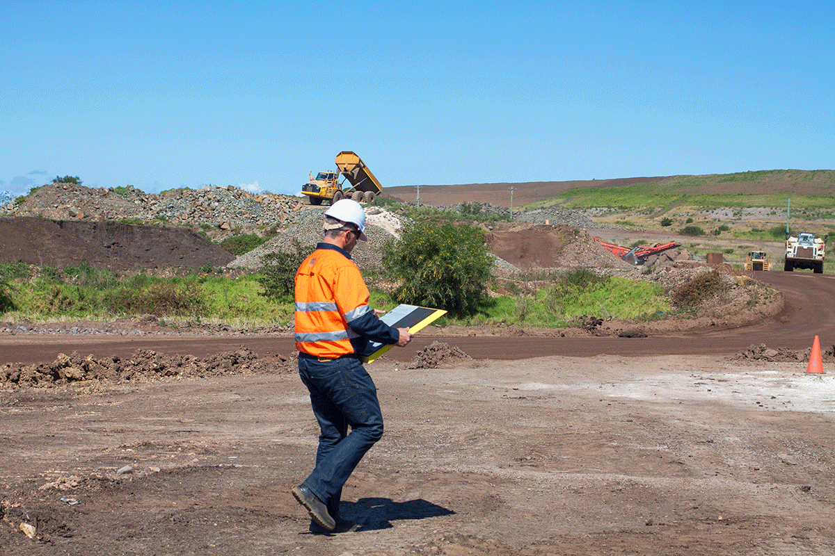
We’ve taken a look at what it means to effectively use a drone as a surveying tool, and in the process of doing so discovered what kind of opportunities Propeller has created for commercial drone operators. The company provides advanced solutions for various industries including construction, mining & aggregates, waste management and surveying & mapping, but their efforts to make drone data widely sharable are what set the company apart. That focus has seen them team up with organizations like Trimble and DJI to create a turnkey drone solution.
How operators can utilize these kinds of solutions to impact their bottom line is one of the key questions that will be discussed at the Commercial UAV Expo. Attendees will be able to connect with the Propeller team to understand how products like Aeropoints and the Propeller Platform can make a bottom line difference for operators. How have professionals in a variety of industries been able to quantify their use of this technology though? Are there challenges associated with adoption?
Francis Vierboom
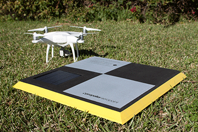 It’s certainly a concept that has permeated the space, but is it one you’ve seen resonating for surveyors? Do you think surveyors are more or less willing than professionals in other industries to embrace drone technology?The surveying profession is built on trust. It's built on reliability. It’s built on repeatability. Those are all things that drones have to establish before they’re fully embraced.I will say that I’ve seen some hesitancy in the industry to rely on drone information, but I think that's a reasonable position on their part to take. The kind of information you can get from drone survey data is good and will get the job done in many circumstances, but surveying is not a monolith. There are a lot of different things you can do with survey technology, and it is possible to gather survey-grade information with this tool. Surveyors are getting a better understanding of what the technology is capable of, and that’s gotten them to be much more willing to look at adoption. When it comes to adoption, do surveyors struggle more with the actual technology or the process to properly integrate it? I think the biggest drone adoption challenge for survey companies is associated with the people who have traditionally been the keepers of the information. Because drone data is straight-forward to share, questions around the traditional business model arise. More than technical issues, which are important and getting easier to overcome, it's really about getting surveyors to understand that some of the things they’re used to doing aren’t necessary any longer.Some surveying firms, especially in Australia, have put a real focus on understanding how to best view their knowledge and move their business toward a new kind of expertise. That's always difficult though. The surveying industry has been disrupted 3-4 times in the last 25 years, first by laser technology, then by GPS, and now drones. It’s not that things aren’t changing, but we’re in the middle of a process that will see widespread use of the technology. Is that kind of widespread use of the technology something that will be enabled by a better understanding of the sort of accuracy that this technology can provide? Yes, and it’s part of the reason we focus on the topo areas when you're looking at doing something like planning and estimating for a major airport. Or when you’re looking at reporting on progress without the process of an actual build. Or the progress toward a design or plan that might be happening in a quarry or a mine where you're tracking airspace consumption on a waste site.In all those cases, you need incredibly accurate information. Differences in fractions of a foot can have a big impact on the number that's being billed and on the estimate you have to make. Getting an accurate output from photogrammetry is very important. The challenge with drones has been to figure out how to retain all the benefits of an autonomous craft that can cover a large area very quickly, but without giving that all away again by having to use conventional survey equipment to go out and create the ground calibration points.With ground control, you can make it fast. It's the gold standard for getting an output from photogrammetry, which is what AeroPoints does. How do AeroPoints simplify what it means to gather and utilize this accurate information from a drone? AeroPoints basically uses PPK-style processing to achieve very high accuracy within 2cm. It's the kind of accuracy you find on high-end equipment. We're using the same underlying technology algorithms, and getting the same accuracy. But AeroPoints are able to provide some additional benefits by having simultaneous data streams.Because the AeroPoints are all recording GNSS information at the same time while they're out on the site, we can use the data from all of those streams to get a better individual result on the AeroPoint accuracy. We refer to it as Global Accuracy and Internal Accuracy. Breaking that down turns into a very technical conversation, but the important thing to know is that the info we can provide is more accurate because the relative accuracy between the points is sub-cm.
 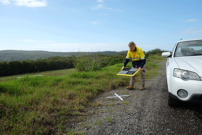 Your post that lays out a comparison of AeroPoints versus a Total Station is a great showcase of the kind of accuracy you’re talking about. How difficult is it to get up and running with AeroPoints though? We built AeroPoints to be a technology that’s as easy to use as ones that are already being used by commercial surveyors. The learning curve is short. Basically, once you get the physical AeroPoints out of the box, all you have to do is go to our website to type in the code, connect them, and then you're ready to use them.You do need to pay attention to some of the key principles of aerial surveying about how to lay them out and how much space you'll need on the site, but apart from that, the technology is designed to be straightforward to use. How have you seen the accuracy AeroPoints can provide make a bottom line difference for you clients?The accuracy the system can provide has a massive impact on the bottom line for our customers. As an example, if you have a ground survey of an area and you have a discrepancy of a foot, you can be talking about an estimate that is many thousands of dollars over or under what it needs to be. Professionals understand that, but what they’re coming to realize is that AeroPoints are the most accurate drone survey technology that you can get. What that really means is that there's a faster, cheaper and safer benefit associated with using the technology that they can quantify.You can do topos by walking over the area with a rover, but it will take days, and you have someone in a hazardous location. Plus, you'll only produce something that's useful for one purpose. Using a drone means you've done it quicker, without someone in a hazardous situation. You've also got a more helpful result, which can be used not only for that estimate process, but also for a variety of tasks and needs related to planning or environmental issues.We're really proud of the fact that we're playing a part in how businesses are developing a new way to capture and use data. By making AeroPoints, people can reliably deliver accurate information that helps them with a reputation for delivering trust and accuracy. And is the role drones can and are playing for businesses something you’re looking forward to talking through with attendees of the Commercial UAV Expo?Absolutely. It’s always great to be able to connect with users and potential users to discuss their specific questions and issues. Plus, we've got some really amazing new features in 3D analytics which will help create new opportunities for businesses to grow. Stop by booth #729 at the Commercial UAV Expo to learn more about how this technology can impact your business.


Comments