


The UX11 from Delair made waves throughout the industry when it was announced and showcased at INTERGEO. Positioned as the ultimate solution for geospatial professionals focused on large-area mapping, Delair has made a conscious effort to ensure users will be able to easily incorporate it into their established workflow. The drone’s flight time, 3G/4G connectivity and fully-integrated camera plus on-board processing capabilities are just a few of the features that were specifically designed to simplify the adoption process.
It’s one thing to talk about easing drone adoption challenges and quite another to actually enable them though, and that’s why we wanted to find out what it will actually mean to integrate the UX11 into a mapping toolkit. Where will professionals see a specific difference when adopting the UX11? Are there certain opportunities that will be opened up by the 3G/4G capabilities? Should users think of the UX11 as a complete drone solution?To find out these answer and plenty more, we connected with Chase Fly, Geospatial Product Manager for Delair. In the interview below, Fly explains what kind of opportunities the UX11 is set to enable and provides key insight that will enable you to determine if it’s the right solution for you.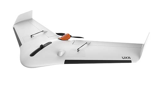 Jeremiah Karpowicz: When we caught up with him at INTERGEO, Benjamin Benharrosh mentioned that the UX11 had been in the works at Trimble, but Delair finished developing it. Can you talk a little bit about the potential you saw in the product when you first learned about it?Chase Fly: Trimble had a great team of experienced UAV engineers within the Gatewing group in Gent, Belgium. These engineers had already developed two generations of successful fixed-wing, purpose-built drones. They had lots of ideas on how they could improve upon the current generation of products, but many of these ideas just weren’t feasible upgrades to the UX5 – they required developing a whole new product.Delair saw a group of brilliant engineers with several years of legitimate market insight gained from working hand-in-hand with Trimble’s geospatial dealer network around the world. They had a great concept they had started to develop on but needed additional resources to make it happen, which is where Delair came in. Additionally, the Belgian plant had some very advanced production processes and capabilities in place that allowed for scalable production of drones. The potential lied in their ideas for creating a professional mapping drone that was easy-to-use and feature-rich, then having the distribution power to make it a success. Do you think the UX11 fulfills the original vision for the product, or has it been taken in a different/new direction? There have certainly been modifications to original concepts, but I think the original vision for the product has remained intact. The UX11 is focused on being the new UAV of choice for surveyors and GISers for small to large-scale drone mapping. The UX11 is designed to be so easy to use that the operations are no longer a distraction to the mission – which is efficiently collecting high-quality geospatial data. What kind of an impact do you envision it will have on the geospatial market?We envision the UX11 will assist the geospatial market in shifting the drone conversation from the hype of the drone hardware to the value of the data. This movement is already taking place in the larger market conversation at conferences and in industry media, but for those of us in the trenches trying to turn ideas into revenue, still too much of the sales conversations are about hardware specifications, performance, and cost. The technology is still maturing and we believe that it will be evident that our 3rd generation mapping drone is easy to use, safe, priced right, and does what it is supposed to do – take high-quality, precisely positioned aerial photos that produce accurate maps. Thus, we intend to make that drone hardware purchasing decision faster and easier for the geospatial market so we can all spend our time and energy diving deeper into the data and extracting business intelligence. With that focus on efficiently collecting geospatial data, can you talk a bit more about the type of professional that is going to get the most out of the UX11?The core users of the UX11 will be professional land surveyors, GIS professionals, construction crews, civil engineers, and environmental consultants. Applications will include topographic surveys, wildlife habitat surveys, real estate development, economic development by public agencies, wildland management, and hydrologic modeling to name a few. Surface modeling, hazard analysis, and volume calculations will continue to be popular with this system by mines, quarries, and landfills, but with the added benefit of our “birdlike” takeoff and landing (BTOL).
  Where and how will these types of professionals see a difference when using the UX11?Often sites in confined areas like mines and quarries struggle to get the most efficiency out of a drone for mapping. The ability of drones to produce the data they need for accurate volume or cut/fill calculations is one of the best-documented and proven applications, but these companies often have to choose between a fixed wing drone for which they cannot find a safe area with enough space for takeoff and landing, or a multirotor that lacks the endurance to get the job done quickly and efficiently.The UX11 is hand-launched and takes off at a very steep angle of attack to quickly rise above obstacles. Then the landing is even cooler - on its final approach the UX11 will descend at a very steep downward slope. It is equipped with a distance measurement sensor that will detect when it is a few meters above the ground at which time the drone quickly rotates upward into a deep stall and then sets softly on the ground with almost no skidding at all – like a bird (BTOL)! This means you can operate it in more areas than other fixed wings, and you can get more work done in less time than multirotors. Will the longer flight time open up new opportunities for operators? If so, in what capacity? Yes, it certainly will.More flight time, combined with the ease of swapping batteries and getting the UX11 back in the air will make it a highly-productive mapping drone. Combined with our 3G communication link, this also opens up a real opportunity for BVLOS flights where possible.Many parts of the world where Delair has distribution are able to operate BVLOS and eventually the western world will have policy in place to allow it as well. Operators really need endurance to unlock the value of BVLOS. After all, how far can you go in 25 minutes? We believe being able to fly for up to an hour can cut down on in-the-field logistics and allow more data to be collected in a concentrated period of time. Time is money for a lot of customers, such as construction. The less time you have to disrupt regular operations for a survey, the better. Can you further explore some of the key features of the UX11?Besides operational improvements such as the takeoff, landing, and flight performance enhancements we’ve developed, the UX11 brings three unique features that set it up to last well into the future:
- an embedded electronic system with a fully-integrated camera and on-board processing enables benefits such as real-time quality checks and the ability to continually develop new functionality,
- 3G/4G communications as well as 2.4 GHz.
- PPK on-demand which enables affordable, incremental access to PPK accuracy when you need it even if you have the base model.
- BVLOS communications are hard. Consumer, prosumer, and the majority of professional UAVs use similar communications systems between the ground control station and the UAV and most all of them are quite limited on the range you can reliably maintain link. We have many existing customers using our products who want to fly farther in BVLOS conditions but are limited by comms range limitations. With 3G coverage, your range is virtually unlimited anywhere you have cell coverage.
- Buildings and terrain get in the way. Often direct radio links like 2.4 GHz are lost when there is a building, hill, or other obstacle between the operator and the drone. Direct line of sight is critical for standard operations, but 3G removes that obstacle. Now both machines – the UX11 and the Ground Control Station – are connected to a private network by using local 3G service virtually anywhere in the world, and all through SIM cards and plans provided through Delair. So obstacles or not, communications will be there.
- Radio interference can be a problem. Many UAV operators encounter significant interference on a 2.4GHz comm link, especially in parts of the world where they operate in urban environments. They may be able to see the drone just fine, but they can lose communications, and that is a scary feeling. 3G infrastructure is often very present in these places and the frequency is much less prone to interruption. This provides for safer operations in more places.
- Where regulations allow, you can feasibly conduct BVLOS flights over that open pit mine or construction site just by stepping outside your office. No need to get in a truck and take a drive if you can safely launch and monitor the flight from the picnic area just outside the office.
- The UX11 can leverage the embedded camera to transmit low-res photos back to the GCS for real-time data review. While you monitor that flight from the picnic area, you will be able to see what your UX11 is flying over and make in-flight judgement calls based on data quality.
- You can operate in urban areas or dissected terrain with a lower risk of losing link. Many people want to use the UX11 for urban planning, economic development, and even cadastral mapping of populated areas where 3G can enable operators to avoid signal interference from obstructions or competing signal noise. In the mountains the UX11 may be used for forestry, powerline inspection, oil and gas, invasive species mapping, and environmental work. These types of operations are especially popular in parts of Asia, Africa, and South America, and the 3G communications will make these operations more feasible.


Comments