

Understanding how professionals are actually using UAVs is a critical consideration for anyone wanting or trying to properly leverage the technology. What does it actually mean for someone to use a drone in the field? Will utilizing a UAV create efficiencies that can be quantified? How is all of that impacting the bottom line for the project? These are questions professionals want and need to have answered, but the challenges associated with doing so stem from the fact that all of this is new technology. It’s not as if working professionals learned about how they could or should be using the technology when they were in school.
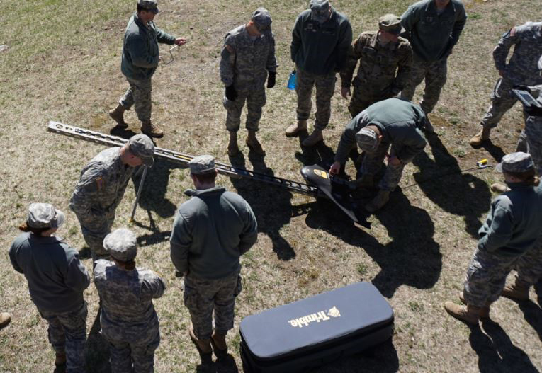
That won’t be the case in the near future though, as various programs and universities are working to integrate drone technology in an active way into what students are learning in the classroom. Doing so isn’t just about using drones though, because the reality is that UAVs will soon be thought of as just another tool. Before that happens professionals will need to have a nuanced understanding around how the technology can be leveraged, and that’s exactly what’s happening in courses at West Point and Virginia Commonwealth University. UAV Technology Comes to West PointThe Geospatial Information Science Program at United States Military Academy, West Point, has been around for about two decades. Started by Dr. John Brockhaus, the course is centered on the science of information technology, specifically the geospatial side. To major in the program, cadets have to take 40 courses, and that includes GIS remote sensing, surveying and photogrammetry.West Point is focused on incorporating modern technology like drones in the curriculum because it creates options for graduates. The Department of Geography & Environmental Engineering that Lieutenant Colonel Jared L. Ware belongs to is a small one, but he knows that what they’re doing in it will enable opportunities for cadets in military and non-military contexts.“Initially all of our graduates will be commissioned as Second Lieutenants in the Army,” Lt. Col. Ware said. “We’re seeing graduates utilize a lot of the engineering skills they learned in our program in their jobs as Lieutenants, but we’re also seeing plenty of those graduates go into public and private industries. Some are working in various government organizations like the Department of Defense and Department of Transportation. We also have a few cadets that are now working with Esri or other software companies in the geospatial industry.”The Academy’s GIS program has been accredited by the United States Geospatial Intelligence Foundation (USGIF) and it includes 40 core courses and four GIS-specific courses. The Academy has two drones, a fixed wing and a quad-copter, and they’re able to give cadets the kind of hands-on experience with the technology that is having a huge impact around how they approach gathering and processing data.Much of that was a recent development though. The faculty was trying to figure out how they could improve their geospatial workflow since it’s one of the things cadets specifically study. Using hardware like the Trimble UX5 and software like Esri’s Drone2Map has given students a whole new perspective.“We have cadets who have a background specifically in GIS, some in remote sensing and some who are just in information processing,” Lt. Col. Ware continued. “So we gave them all a project to create a map. They were able to produce very specific products from the information produced in Drone2Map. It sped up the workflow, which was great because it allowed us to spend more time on the science and the analysis rather than the processing. It’s really helping us change our curriculum for the better.”Seeing that change from both the perspective of educators and students is a critical consideration, because it’s meant both have more time to focus on essentials that might have otherwise been sidelined by logistics, such as processing. However, that’s not the only consideration around using these tools in the classroom.
Students following the UAV with live updates for situational awareness and mission acquisition with the help of instructor, William Shuart, M.S.

3D digital surface model (left) overlayed with true color orthomosaic (right) of the VCU Rice Rivers Center.
 A Different Way of ThinkingMuch like working professionals, both instructors and students have seen drones and the tools associated with them completely change the timetable around when and how something can be done. A project that would have taken six weeks to do using traditional survey methods can be flown in an afternoon. After post-processing you can have the asset that you’re looking for in the next day or two. That kind of speed is a factor in how intricate and complex these projects can be, which makes them all the more relevant to the career’s of students after they’ve left the classroom.“We had a pretty robust dataset that we collected over Range 11 here at West Point, which is about 80 acres,” Lt. Col. Ware said. “We collected 3cm spatial resolution. After post processing it we were immediately able to produce orthomasaic and also the surface model, and then we were able to use that to produce a 1/3,000 scale map.”
 That project served as the cadets’ final project, and being able to consider the details around how they could and would capture and deliver such detailed and accurate info was more powerful than the deliverable itself. It’s something that was just as prevalent at Virginia Commonwealth University as it was at West Point.“We want to integrate all the technology that's available to us so that students can really get an understanding of how to acquire, process and interrogate those data rather than learning how to use a complex program or device,” Shuart continued. “What matters more are the workflows and datasets and how we answer questions associated with those data rather than the intricacies around specific pieces of hardware and software.”Applying drone technology to answer questions that students are dealing with before and after they capture data is the real crux of the issue. Both classes are focused on the question and answer period that arises when a project is being planned. Students focus on coming up with a hypothesis, acquiring data and then processing it to provide analytical products.These classes are meant to take a platform with sensors, collect data, process that data and then produce a final product that provides value and is associated with those original questions or issues.
William Shuart, M.S., instructing students at the VCU Rice Rivers Center in pre-flight planning, sensor calibration, safety, and post-processing using eMotion from senseFly and ESRI's Drone2Map.

Aquatic experimentation area at the VCU Rice Rivers Center.

Green roof vegetation health analysis at the VCU Rice Rivers Cneter. Data collected by a senseFly eBee (2in/pixel), Parrot Sequoia multispectral sensor. This allows management to identify areas to fertilize, water and replant.

.jpg.small.400x400.jpg)


Comments