

Like many government agencies, the Bureau of Reclamation (Reclamation) has evolved over the past few decades, and technology is fueling these changes faster than ever. When it was founded in 1902, the department was tasked with ensuring there was enough water to take care of the needs of all the people that were moving west. Over time, Reclamation developed nearly 500 dams, 350 reservoirs associated with those dams, and over 8,000 miles of canals and pipelines, to store this water, manage it, and move it to where it was needed.
Today though, Reclamation is not focused on building dams, but instead on maintaining them. These facilities have the potential to be around for hundreds, if not thousands of years, which means they all have to be managed and maintained. Reclamation officials work with partners on either a local, state or tribal level to make sure they are managing resources appropriately to deal with flooding and irrigation issues, but new technology has changed the approach to this process.Tools like Revit and drones are changing the way things are done for the better. An ambitious project that is underway to create a 3D digital model of Glen Canyon Dam, one of the world’s largest concrete dams, are providing officials with the information they need to continue to manage facilities like this for the American public today and far into the future. Asking “What If?”David Winslow is CAD manager and GIS coordinator in Reclamation’s Upper Colorado Regional Office in Salt Lake City, and he’s been intimately involved with the agency’s efforts to efficiently detail what’s happening at and with the Glen Canyon Dam. His perspective is a unique one, since he’s worked at Reclamation for 33 years as a civil engineer and has seen the transition from hand drawings to calculators to computers. These new tools aren’t simply about creating efficiencies though. They’re about creating opportunities.“Because the tools are so much more efficient, they've given us the ability to do more ‘what if?’ type scenarios,” Winslow said, “In the past, our tasks were as simple as ‘design this road’. Drawings were done with pen and ink by hand, and in a lot of ways that constrained what you could do. Today, with the different forms of CAD that we can use, we can take that same road and play around with moving something 20 feet to the left so that you bypass something that's in the space. Now we can do our job more effectively because we can look at many more options.”As officials keep adding all these different tools to their toolset, they get more information, more data, and more options around to how best design, redesign and manage these facilities. These are critical details to explore, since they can allow officials to stop issues before they turn into problems, and that’s a serious consideration when you’re talking about issues like flooding.“The last thing we would want is to have something happen because of an issue that we didn't catch which causes flooding and impacts the lives of people who are downstream from our facilities,” Winslow said. “In a lot of ways it's like medicine. A doctor can make the necessary diagnosis and give us the pharmaceuticals to take care of the issue before it becomes life threatening. It's the same thing with this facility. The more we know about what's going on, the more prepared we are to fix potential problems, to make sure they don't cascade into something much larger.”The more officials like Winslow know the facility and how it interacts with the canyon around it will allow them to better manage and upgrade that facility. That knowledge is being enabled with new tools like drones that are giving them a whole new perspective around what’s happening within these facilities.
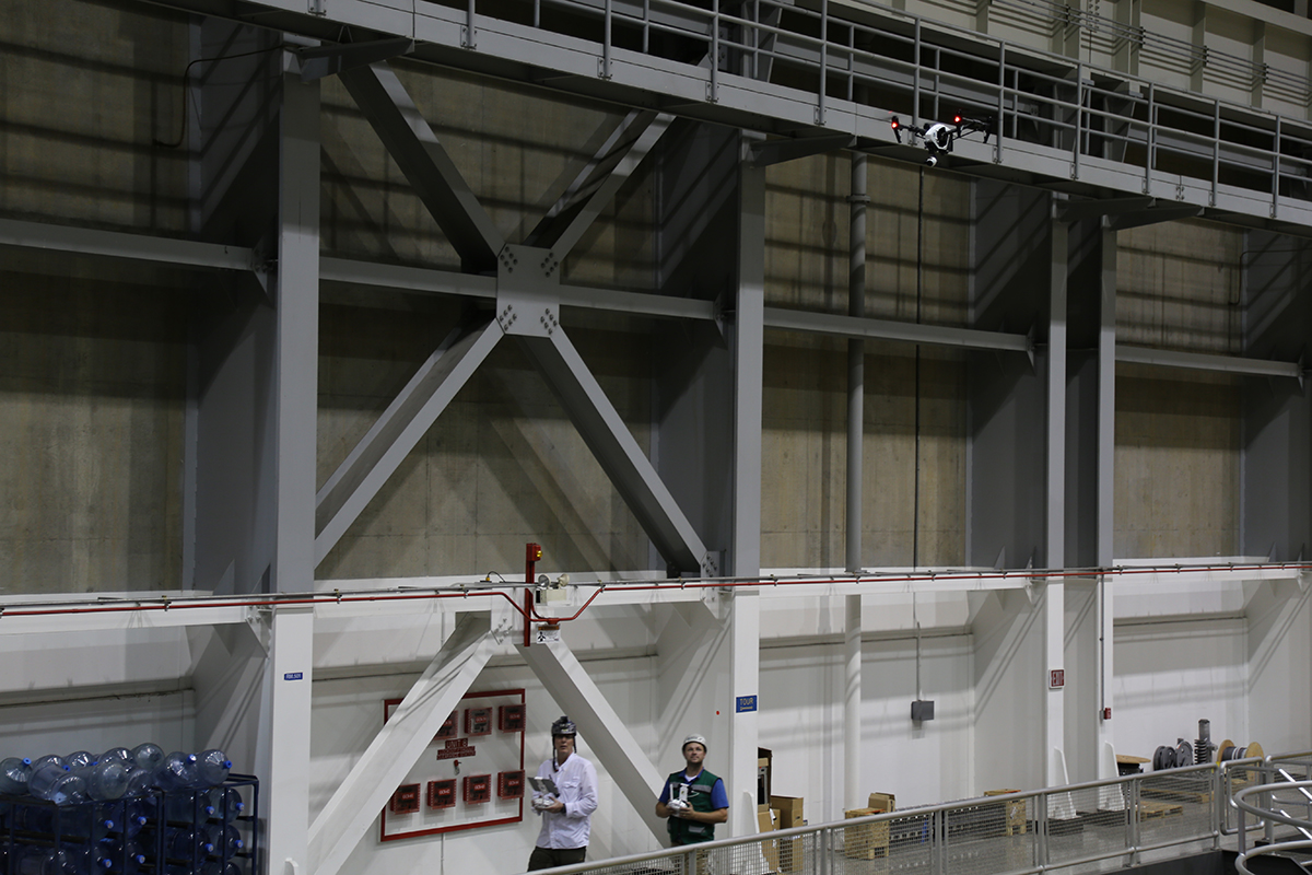
 Drones and DigitizationGlen Canyon Dam is what's called National Critical Infrastructure (NCI). That designation means if this facility were to be lost somehow, it would greatly impact the nation. This facility stores and manages water not only for the local area, but for all of the downstream users, which would impact facilities like the Hoover Dam and in turn the commitments and requirements the United States has agreed to by treaty to deliver water to Mexico. These stakes are just part of what compels an active exploration around how tools like drones can make a difference, even as officials have to deal with regulatory issues.“With regulation being what it was and is, there were just too many issues with it to be able to actually use a UAS on the exterior,” Winslow said. “The interior space was not as heavily regulated, so we were able to allow Autodesk to fly a drone inside the main generating room. We had been using stationary scanners in that environment, but we couldn't get up to the top. There just isn't any way of doing that, so the drone provided us additional information to help us see into these corners where we couldn't see otherwise.”The success the organization has seen in this interior environment has helped compel them to more fully explore what they can do on the exterior, and Reclamation officials are getting certified as drone pilots. They’re also experimenting with a variety of airframes, and are committed to seeing what’s going to work best since they’ve already seen the power of this data. This process is about something much deeper though.A large dam like Glen Canyon is just like your sidewalk or driveway. If it's concrete, it will crack. Reclamation officials know that's going to happen, because with nearly 5 million cubic yards of concrete, there are going to be cracks. Because of that, there will be some water seepage into the dam, and officials wanted to get a better understanding around whether or not a crack that was in one location was going to impact or create one elsewhere. That desire was stated a long time back, but the digitization process has created a whole new way to document these details.“When I created the original 3D model for the dam about 20 years ago, I went through the entire dam, using the original design drawings to create a 3D model of the interior galleries,” Winslow explained. “From that, we started to get a better understanding of the interior of the dam itself, and how things were all positioned, but it only gave us so much information. Then I started to say we needed something better. We couldn’t rely on individual drawings anymore. It wasn't an as-built, it was just as-designed. I'm assuming there are discrepancies in that model, but with this new scanning project, we can get that information and it's in as-built condition.”The concrete in this dam will likely be around for a couple thousand years. Reclamation manages this facility for the American public, and in order to do that the best way they can, they’ve made conscious efforts to embrace new technology, but the effort to do so isn’t always a simple or easy one.
 The Future of an Agency and IndustryReclamation absolutely does and wants to adopt new technology. The process to actually do so can be a cumbersome one though, as it can be difficult to compel change and adoption. Even when the efficiencies are there and proven, that process isn’t always an easy one.“There's no sugar coating it: it's a hard process to go from the analog world to the digital world,” Winslow said. “We have a lot to do, but if you find people who have a passion for doing this, and have an aptitude for doing it, they can become your champions, and they can make it happen, but they need to be given the time, resources and support to make it work.”The pace of progress isn't going to slow down because someone isn’t ready for it, and it’s why Winslow recommends anyone going through a similar process to find partners they can work with, who can help find the best methods in order to establish a checklist to make these things happen. Logistics can present a challenge, since at this point in time there is no easy way to go from the point cloud to a BIM model. It's a lot of work and a lot of effort, but the outcome on the other end can be especially worthwhile and lead to even bigger things.“We started this with some clear objectives that we're working through, but we've gone into areas that we didn't even think of originally,” Winslow said. “We're looking at creating a VR experience that we might be able to use in our visitor center or in education outreach programs. It can also be used to help our own employees understand how everything fits together in these types of facilities. It's been a long ride and there have been tough weeks, but I see it as being very important to this agency and the nation.”The opportunities that are being utilized and created with these new tools are changing things for agencies like Reclamation in the present and the future. They’re ensuring information being gathered today will impact what’s being done to keep these national critical infrastructure facilities functional in the short term and long term.

.jpg.small.400x400.jpg)


Comments