

More and more people throughout the drone industry have come to focus on the software used to analyze, sort and process the data gathered by drones, rather than the hardware that is used to gather that data. This transition makes sense, as data is being hailed as the new oil while commoditization is predicted on the hardware side.
Many surveying and mapping professionals have recognized the power that is inherent in the data drones can gather, as it can be utilized to save time in the field and cut down on operational expenses, all while achieving accurate results that allow professionals to complete a job more safely. Drones (aka UAV technology or UAVs) can enable incredible efficiencies, but what does the process to achieve this kind of effectiveness actually look like? What tools should be used to help make sense of all the information these tools can gather?These are the sorts of issues OHM Advisors worked through as they figured out how they wanted to utilize UAVs. Their efforts to effectively leverage drone hardware and the data they gather with software like Datumate provides a great showcase of where and how this technology can make a really difference.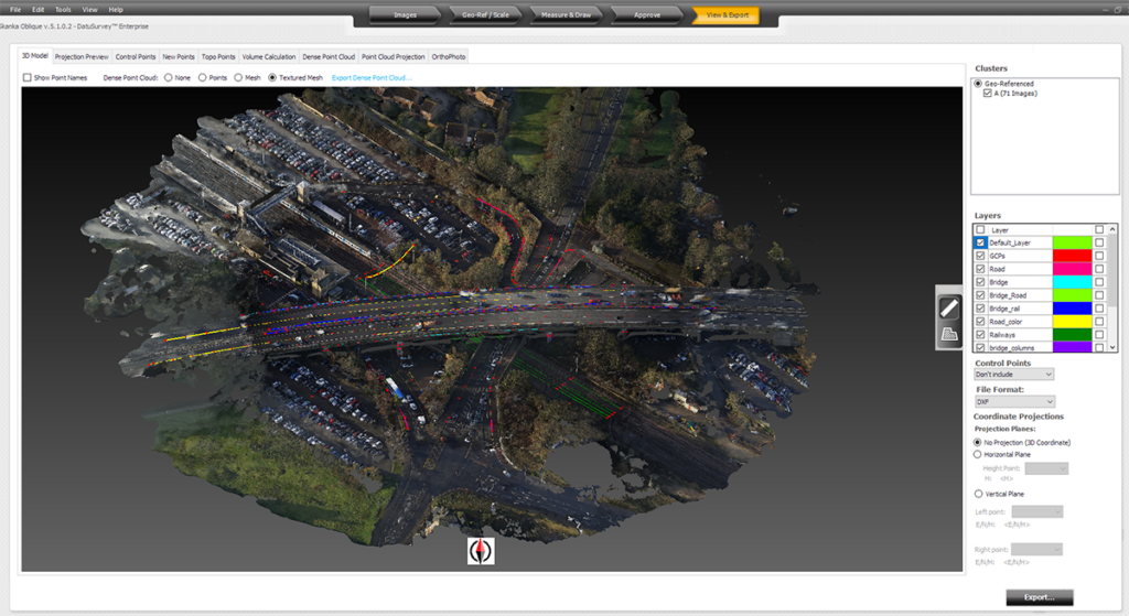 The Drone Adoption ProcessOHM Advisors is a community advancement firm providing a wide range of architecture, engineering, planning, surveying, and construction engineering services to public and private clients. As such, Ray Lillibridge finds himself working on a variety of projects for the company. A licensed surveyor in California and Michigan as well as a Survey Technical Specialist for the company, he’s tasked with evaluating new pieces of technology to figure out how these tools can be best utilized for a variety of applications.This wasn’t always his role at OHM Advisors though, and the previous adoption process didn’t always take place at the company level. More times than not, it was at the discipline level, which meant a siloed approach to technology adoption. Being able to explore what these new tools can do in a holistic sense has changed their policy around adoption for the better.“In my current role, I meet with all the different disciplines in order to look at things from a company-wide perspective,” Lillibridge told Commercial UAV News. “What we do now is someone will identify a new technology they wish to implement. My team and I take a look at it, see how it integrates with current workflows, see what changes have to occur, what it costs, what training looks like, etc. There's a lot out there on how to use something, but there's not a lot about what that actually should look like in your company. It’s my job to figure that out.”Doing so has become more of a software issue than a hardware one, even as the company realized how drones were going to change survey operations. Drones allow professionals like Lillibridge to apply traditional aerial imagery philosophies on a smaller and more accurate scale. Once FAA regulatory issues were cleared up under Part 107, the biggest challenge for OHM Advisors centered on how they were utilizing all of the data they were gathering. Luckily, they had already been using a software solution that made their learning curve around being able to do so practically non-existent.
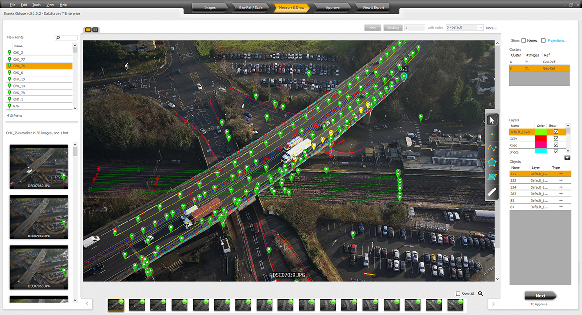
 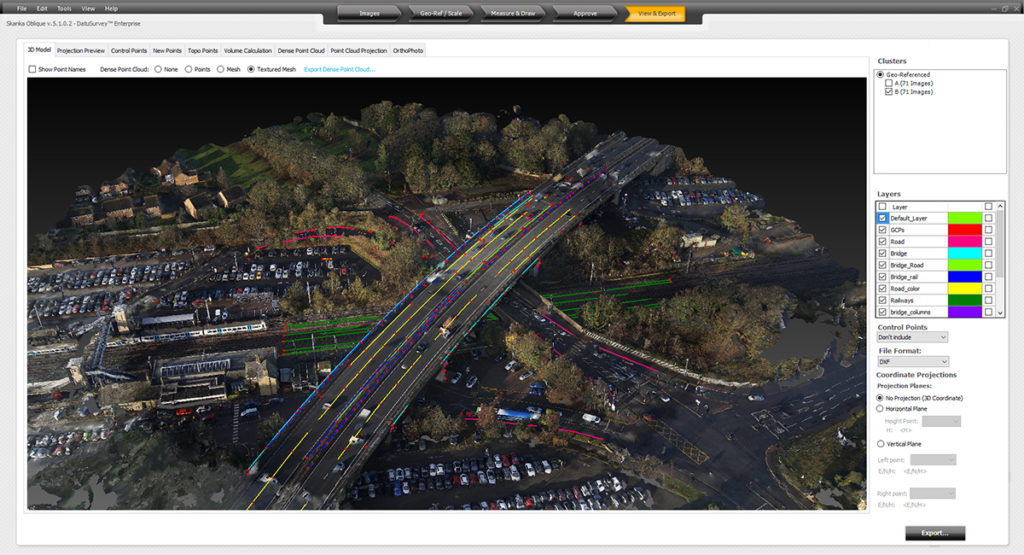 More Precise Results and the Ability to Manipulate Data as Necessary About two years ago, OHM Advisors conducted a survey of a small facility and all of the small, intricate details within that facility. Using the Datumate solution, they placed sticker targets, like simple crosshair targets, on various items, locating those with a prismless total station, and then walked around the site with a 24 megapixel point-and-shoot camera. Essentially, they were using a low-level point-of-interest drone flight. That made their eventual drone adoption process that much easier, but it also made it easier for them to understand what they wanted and needed out of their software solution.“There are multiple, simple-to-use photogrammetry software options out there,” Lillibridge explained. “Once you establish your GCPs you can let those rip and get a usable point-cloud. That’s fine for some people, but I want to choose my own points. Datumate allows us to accurately pinpoint the locations we want to identify. After doing that, you’ll receive residuals on each point to see how well it's calculated by identifying multiple photos. From a surveyor’s standpoint, it makes a lot more sense than dealing with millions of points you will not use from a point-cloud.”This process might involve some extra time, but it also results in more precise results that can then be adjusted as necessary. It allows users to calculate volumes, surfaces and planes on the fly. Additionally, once users have picked their points, they can export a CSV. The process is much simpler than comparable pieces of software, as most survey firms are exporting a CSV out of their field data collectors.Whether the info is coming from a total station, GPS unit or drone mapping, the CAD technician processing shouldn't see a difference with the Datumate solution. It's all going to be the same. It's all going to be a comma delimited file. That ease of use ties in where the software has made a bottom line difference for OHM Advisors.
  A Logistical and Bottom Line Difference The way in which UAV technology can make something faster, cheaper or safer is a concept that comes up in many different contexts, but utilizing the right software to ensure this efficiency is actually being created is something that doesn’t get talked about enough. That being the case, where and how does OHM Advisors actually see these kinds of efficiencies?“It really matters on a lot of our civil design projects,” Lillibridge mentioned. “Primarily, that's what we've utilized our drones for, and it is phenomenal in that aspect. If we want to get a cross-section at the change of slope on a particular road, you can easily see it in Datumate. The problem with virtually any other software is that you have to manipulate a point-cloud to get that kind of specificity. Sure, you can decimate and process a point-cloud down as much as you want, but you're still looking at heavy processing power.”Organizations larger and smaller than OHM are in the process of figuring out how to properly leverage drone technology, and the role software plays in that process is something that cannot be ignored. OHM has come to trust Datumate because they’ve gotten to the point where any issues that arise associated with the data can be traced back to the photos or the project. That’s not the kind of reliability they have when dealing with a point-cloud, and it’s a difference that can be measured in terms of how they’re able to quantify the value of the technology they’re using.


Comments