

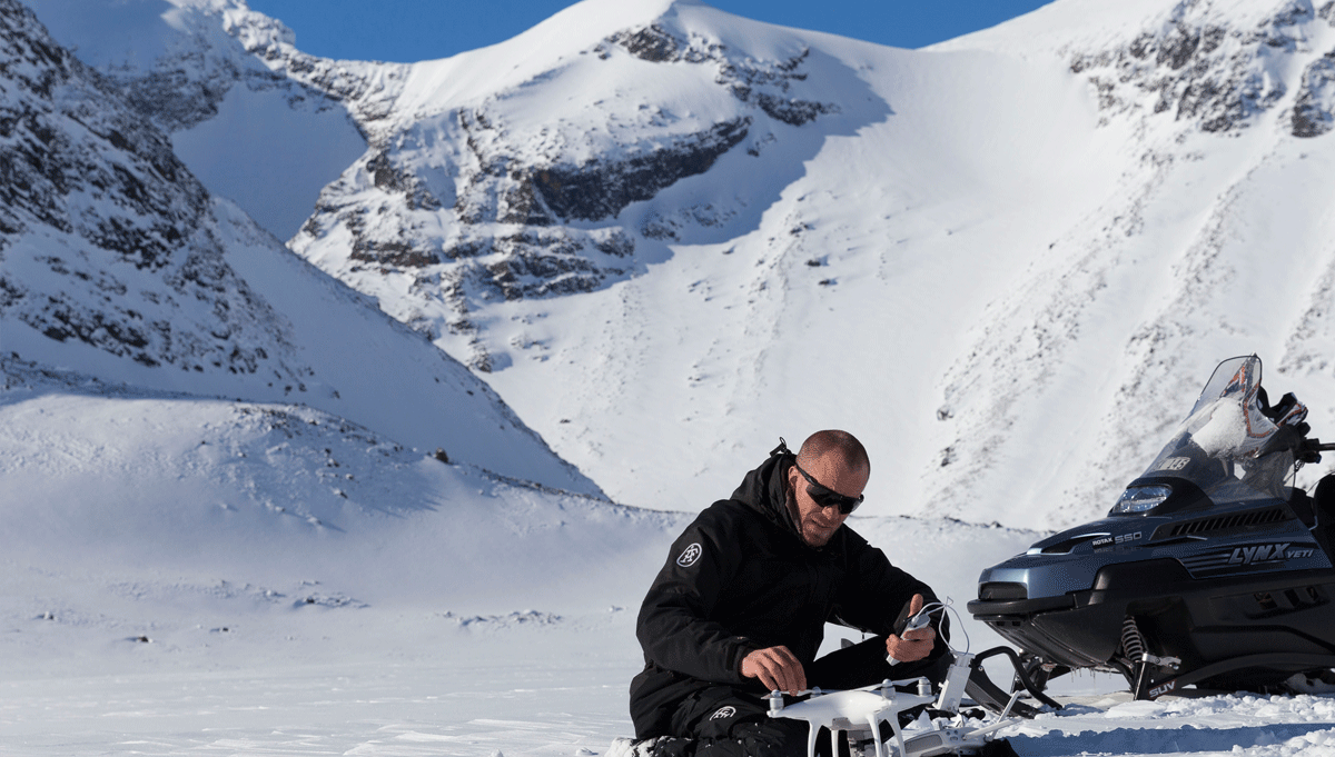
Arguments about what is or isn’t happening with climate change continue to rage, and that’s why it’s more important than ever for people on both sides of the issue to have the facts. Drones are being deployed and counted on in extreme polar environments to gather those facts. UAVs are being used by research teams to detail the rapidly melting sea ice in the Arctic in order to provide a better picture of the situation and properly shape this discussion around global warming.

Tomas Gustafsson
 What can you tell us about the Interact project "Drones in Arctic Environment”?The main objective for the Interact project is to build capacity for identifying, understanding, predicting and responding to diverse environmental changes throughout the wide environmental and land-use envelopes of the Arctic. The project “Drones in Arctic Environments” will transfer UAV technology from industry to scientists. The project will also identify applications through cooperation between arctic researchers and technology industry (drones and sensors) and evaluate UAV requirements for scientists at Arctic research facilities.Furthermore, we will identify and propose suitable sensors and drones for the Arctic research environment and also try to give some guidelines regarding general rules and legislation with an application on the Arctic environment and their respectively countries. We will use the existing market and act as facilitators between drone and sensor technology companies and the arctic research community. The “Drones to save the Article Sea Ice” article lays out some great detail around why the work you’re doing in the Arctic is so important. Ultimately, what will be done with the info you’re gathering? Will it be utilized to influence policy in the EU or in individual countries?Primarily we are doing this for the Interact project and the scientists, but in the long run their results affects and controls how the policy and today even the politics in the world are dictated.It’s exciting to see how this agenda is influenced by the results that we are a part of collecting. That is especially obvious today, when Arctic is on the agenda and in the news almost every day.
 Do you believe the info that’s being gathered for this project by drones will change the perception people might have around climate change?Yes, we’ve already seen a huge interest about this project from all areas, from media as well as companies that want to contribute or offer their services for the arctic research community. That’s good, both in order to be successful in the project and help the scientists in their research and also to spread the knowledge and awareness about what’s happening with our environment. The article mentions that there are two primary ways for researchers to collect measurement data: either by satellite from space or manually in the field, both of which have their limitations. Can you talk a little bit about those limitations?We’ve seen that many scientists have high demands and expectations about the collection of data. There’s simply just not enough or correct data in many cases. We really need to use both satellite data as well as collected from a drone.Let me give you an example when it comes to images. We recently learned, from a discussion with Swedish Polar Research Secretariat, that in one of their previous expeditions, that satellite pictures didn’t give them the info they needed. The satellite operators did provide “several high quality pictures”, but the problem came in when they needed to geo reference a small ship in the middle of thousands of thousands of square kilometers of ice. Near the coastline it’s easy. You know where you are and what the ground usually looks like. In the middle of nowhere, in the Arctic, you might know where you are but you can’t refer the satellite images to it. A drone would provide additional, correct and valid information within minutes in this case.Another example is retrieving images in large areas within a short time, which is well taken care of by satellites. On the other hand, real time updates, small scale and in cloudy weather, can’t be performed with other technology than drones.
Both of these methods are needed by scientists to increase and improve their research. Has regulation influenced the way in which you’re looking to adopt and utilize drone technology?There is no reason to not be honest, so let me say it clearly: technology is running very fast and legislation is not in parity or in sync, and that’s a big problem. With that said, I think that all relevant agencies, both the European EASA as well as the national Swedish agency and I believe also FAA in US, are now doing a great job to get up to speed. They really don’t have much choice - the drone market is growing so fast and is of high importance, economically speaking.There are some limitations and issues that we have to consider when flying drones in the airspace in Arctic environments today. Hopefully, we will see legislation evolving and not put limitations on technology.
Do you believe the info that’s being gathered for this project by drones will change the perception people might have around climate change?Yes, we’ve already seen a huge interest about this project from all areas, from media as well as companies that want to contribute or offer their services for the arctic research community. That’s good, both in order to be successful in the project and help the scientists in their research and also to spread the knowledge and awareness about what’s happening with our environment. The article mentions that there are two primary ways for researchers to collect measurement data: either by satellite from space or manually in the field, both of which have their limitations. Can you talk a little bit about those limitations?We’ve seen that many scientists have high demands and expectations about the collection of data. There’s simply just not enough or correct data in many cases. We really need to use both satellite data as well as collected from a drone.Let me give you an example when it comes to images. We recently learned, from a discussion with Swedish Polar Research Secretariat, that in one of their previous expeditions, that satellite pictures didn’t give them the info they needed. The satellite operators did provide “several high quality pictures”, but the problem came in when they needed to geo reference a small ship in the middle of thousands of thousands of square kilometers of ice. Near the coastline it’s easy. You know where you are and what the ground usually looks like. In the middle of nowhere, in the Arctic, you might know where you are but you can’t refer the satellite images to it. A drone would provide additional, correct and valid information within minutes in this case.Another example is retrieving images in large areas within a short time, which is well taken care of by satellites. On the other hand, real time updates, small scale and in cloudy weather, can’t be performed with other technology than drones.
Both of these methods are needed by scientists to increase and improve their research. Has regulation influenced the way in which you’re looking to adopt and utilize drone technology?There is no reason to not be honest, so let me say it clearly: technology is running very fast and legislation is not in parity or in sync, and that’s a big problem. With that said, I think that all relevant agencies, both the European EASA as well as the national Swedish agency and I believe also FAA in US, are now doing a great job to get up to speed. They really don’t have much choice - the drone market is growing so fast and is of high importance, economically speaking.There are some limitations and issues that we have to consider when flying drones in the airspace in Arctic environments today. Hopefully, we will see legislation evolving and not put limitations on technology.  How do you see the role of drones in research like the work you’re doing in the Arctic changing and evolving over the next few years?Drones will be even more popular. They will be a part of the daily work. They will do tasks that today are risky, repetitive and boring. They will take water samples five times a day instead of once a week. They will measure snow depth in remote areas without a day of dangerous hiking on top of a glacier. They will constantly fly in an interesting, nearby area to collect various parameters from the air. They will save time and let the scientists do other things while the drones collect information that scientists previously gathered themselves.They will eventually be as useful and practical as your smart phone is today. What would you say to someone in the research community that said they weren’t sure that drones could help them either in terms of their approach or bottom line costs?I would tell them to request support from an expert that will help guide them to collect the correct and desired data.If your research is focused on, for example, polar bears, you may have studied them for 30 years. That is what you do best and you should probably continue with that.Request support from a drone expert that will serve you with the data that you want, as well as the data you didn’t even knew that you wanted or were possible to retrieve. That will hopefully get more out of your budget.That’s part of what we’re doing with this kind of outreach. I’m headed to Commercial UAV Expo Europe in order to find the hardware and solutions that are going to be a fit for us, because we’re not drone experts. That’s basically my way of saying if you have any technology that you think would be of interest for the Arctic community and the researchers, please don’t hesitate to contact me!I’d encourage others to take a similar approach in order to figure out how to best utilize and adopt the technology.


Comments