
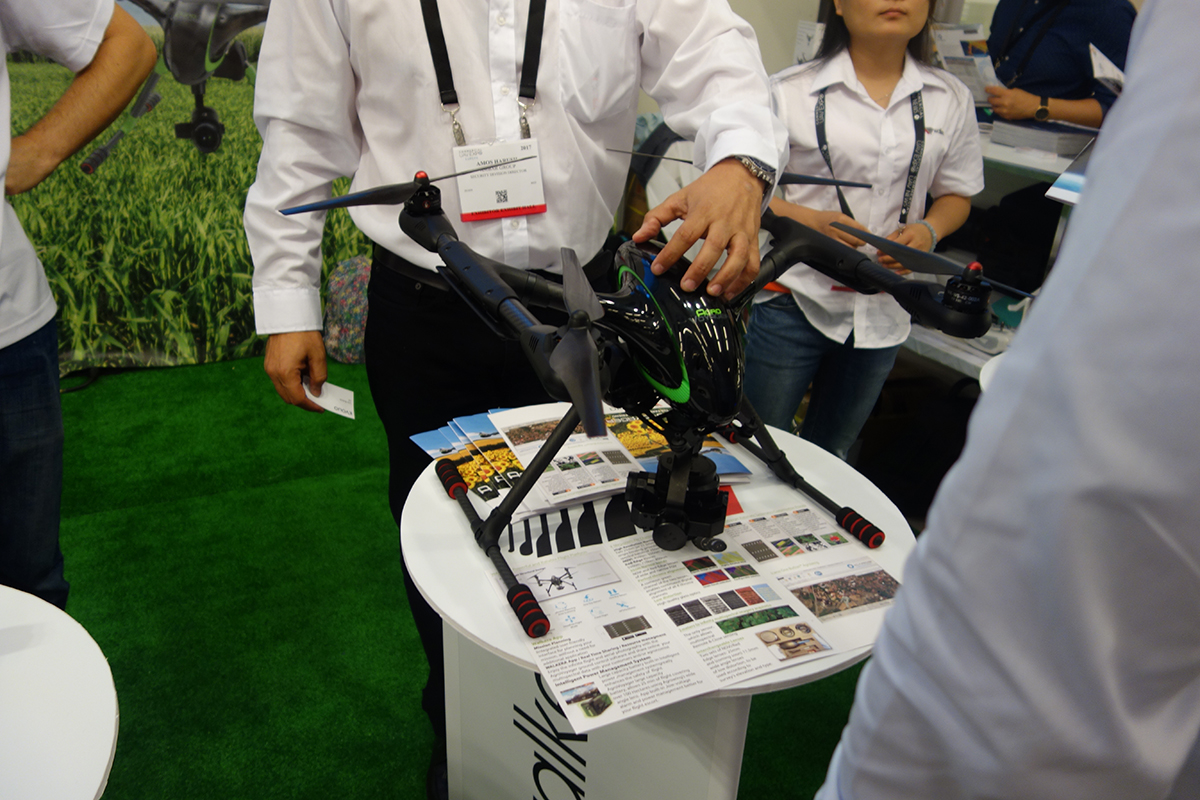
The Fairfax-based company Icaros Inc. partnered with the supplier of multispectral sensors and analytics software Agrowing to deliver an integrated drone multi spectral mapping solution for agriculture. This new bundled solution integrates Icaros’ OneButton Standard Edition with Agrowing’s agriculture and multispectral sensor solutions. What this means is that Agrowing users can now process imagery into high-fidelity fully indexed orthomosaic maps for agriculture, which are crucial for professional precision analytics.
Last year, we interviewed Agrowing’s CEO Ira Dvir, who explained how the company’s solution solves some of the issues current remote sensing practices still have, and that he’s working to turn agricultural remote sensing into an automatic process from beginning to end. By turning DSLR cameras into high end multi spectral cameras, Agrowing’s sensors allow users to capture NDVI and all other vegetation indices on a single sensor, while providing 8MP or 10MP per band. There’s also a 25mm focal length lens that provides images with incredibly low distortion of less than 1%. An additional wide angle, low distortion lens, of 62 degrees HFOV is currently under development.Tom Bosanko, CEO at Icaros said: “There is no other company in the agriculture market with this capability. Compared to the other leading multispectral sensor brands that offer 1 to 1.3 megapixels and lens distortion exceeding 15%, Agrowing‘s 10 megapixels, or 1 to 8 scale versus others, means you can collect almost 5 times the field area, at much higher resolution, with far less distortion, in the same time using the same drone.“Icaros has been focused on providing geospatially accurate remote sensing software products and services since 2004. Its OneButton software, initially designed for manned aircraft sensors but now compatible with UASs, allows users to easily and automatically generate geospatially precise, fully orthorectified 2D maps and 3D models from frame-based aerial imaging systems.“Our long-term experience in large scale multi spectral remote sensing and mapping projects has been incorporated into our photogrammetric software to provide a professional and enterprise scale multi spectral solution”, added Bosanko.Icaros and Agrowing are working closely together to include a correction matrix for the distortion per sensor/lens combination that will be part of the OneButton processing. The latest version of OneButton Standard and Professional editions includes advanced algorithms to process images from Agrowing’s high-end multispectral sensors. Agrowing is now offering the product bundle to drone manufacturers that want to offer a complete solution for the agriculture market.“Icaros and Agrowing have created a one-of-a-kind, professional, state-of-the-art, automated agriculture solution for the global commercial drone industry," said Dvir. "We offer the only solution on the market that is able to acquire high-resolution, low distortion multi spectral imagery from both high and low altitude. This is the first and only solution for Precision Agriculture, which enables the creation of high resolution multispectral imagery bank of vegetation pests, diseases and pathogens.”Later this year, Walkera will combine Agrowing’s and Icaros’ sensor/software bundle with its newly announced drone specifically designed for the precision farm market, the AgroVoyager."We are combining the extraordinary Agrowing multispectral sensor and agriculture software with our high-end AgroVoyager drone specifically targeting the agriculture market. AgroVoyager is the first complete hi-resolution drone solution specifically designed for Agricultural use." said Robert Luo, CEO of Walkera.Trial versions of the complete Agrowing solution can be obtained by contacting Agrowing. Icaros also offers a 30-day trial version of its latest software.Subscribe
The information you submit will be stored and used to communicate with you about your interest in Commercial UAV News. To understand more about how we use and store information, please refer to our privacy policy.
September 17, 2017
An Integrated Drone Multi-Spectral Mapping Solution for Agriculture

Want more stories like this? Subscribe today!
.png.small.400x400.png)


Technology in general makes João Antunes tick, but the specific ways it has created and changed the landscape in IT, gaming and computers ignited curiosity that’s turned into a passion for him. As the son of a journalist writing about how these industries have emerged and evolved, he has an incredible perspective when it comes to understanding the kind of disruption new technologies can create in a given space. He’s committed to showcasing what that disruption will mean for professionals as they work to utilize brand new pieces of hardware, software, systems and processes.
Featured Report
Featured Authors More Authors ›

Featured Authors


Newsletter Signup
Our Events


Our Events
September 1-3, 2026 • Las Vegas
February 23-25, 2027 • Salt Lake City
Comments