As drones have made the transition to being commercially viable tools, the means by which they’re able to stay in the sky have become much more robust and powerful. Xsens is one of the companies that has been and continues to develop those capabilities, and their efforts to do so go beyond the bottom line for their customers. They’re also dedicated to creating technology that will help make the world a greener place.
Xsens is a leading innovator in 3D motion tracking technology and products. They provide sensor fusion technologies, which enable a seamless interaction between the physical and the digital world. This means that they provide orientation sensors and position sensors based on MEMS gyroscopes, accelerometers, magnetometers, GNSS and barometer. Their products are used in a wide range of applications for navigation, stabilization and measurement correction, but we wanted to focus on a couple applications that are making a difference right now.
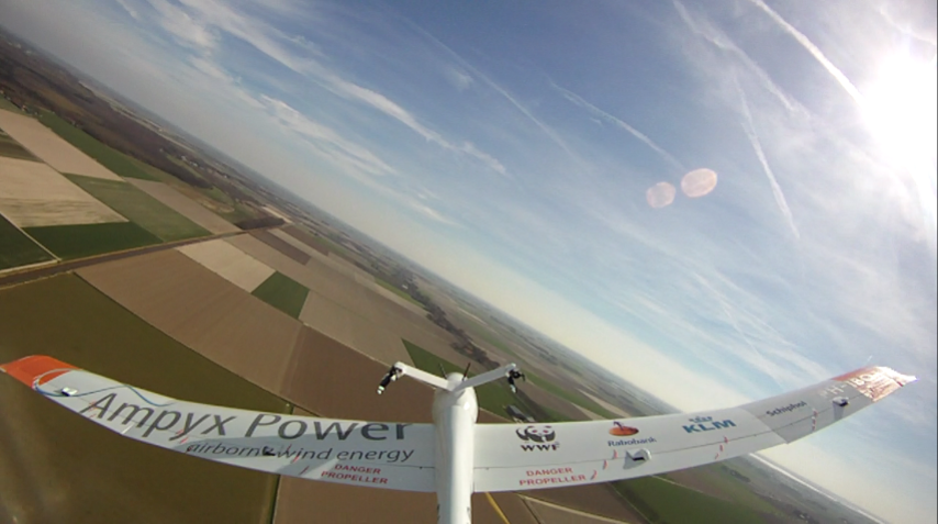
Converting Wind into ElectricityPowerPlane is an autonomous aircraft that converts wind into electricity. It is a drone that is tethered to the ground via a steel cable. This cable is connected to a generator. This generator produces energy when the cable is reeled out by the wind that is driving the PowerPlane up. As you can imagine, there are all sorts of uses and benefits for this kind of technology, and Marcel Van Hak, Product Manager at Xsens, was kind enough to explain where and how we might see that impact.
“The PowerPlane is used in many situations where winds are not strong enough on the ground or when there is no room or commitment for wind turbines,” said Van Hak. “In built-up areas, for example, building a 100m high wind turbine is not always appreciated and may be blocked by the local authorities. The PowerPlane and crosswind kite power are technologies that contribute to a greener world, and keep the environment clean.”
The PowerPlane makes use of cross winds at 100s meter high, where winds are much stronger than winds at the ground. Xsens’ MTi is used to control the plane and to make the system maximal efficient. However, it’s not the only game-changing technology the company is working on.
Drones and Crop Science 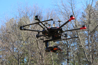
Courtesy of Headwall Photonics
is a company that builds highly precise multispectral and hyperspectral imaging sensors for various markets, and their collaboration with Xsens has allowed them to create a more integrated solution for their agriculture customers. The combination of Xsens GPS with Headwall’s Nano-Hyperspec® imaging sensor has opened up various opportunities for farmers of all types, and the importance of this development is something Chris Van Veen, Marketing Manager at Headwall, was able to explain in great detail.
“When it comes to crop science or any type of spectral-imaging-based ‘remote sensing’ initiative, it’s crucial to have the geographical coordinates precisely overlaid with respect to the image data so the scientist can determine not only what is happening, but where,” Van Veen mentioned. “This can be as basic as managing irrigation and fertilization programs or as complex as identifying the presence of disease conditions on the canopy of crop trees. With planting and harvesting cycles pre-defined, the crop scientist cannot waste time trying to do this integrative work himself.”
Ensuring that farmers are not wasting time is one of the
key benefits of the solution that the companies are working on, but the details associated with that process need to be fully explored.
The ability of Headwall’s imaging sensors to ‘see’ beyond the visible (400-1000nm in the spectral range) means that indices of crop stress and health become ‘visible’ once the data is analyzed. Decisions are better and agriculture is more precise when you pair UAVs with spectral imaging technology. The GPS plays a particularly useful role because it tells the drone where to fly and also instructs the sensor when and where to collect data. The crop scientist can use Headwall’s Polygon tool along with Google Maps to point-select the geographical parameters of the mission. It may be an entire crop field or just a small segment of one. The GPS thus assures mission efficiency because the UAV is flying only where it has been instructed and the sensor is collecting image data only where it is told to. Image data from a single mission can be gigabytes in size, so the ability of this technology to ‘point-target’ specific areas or certain wavebands of interest makes it more useful to the crop scientist.
“A farmer can benefit when the drone and software tells him exactly where the crop is not growing as expected,” Van Hak said. “He can discover the color of leafs far into the field at locations that he could not see himself. Battery powered drones can then spray fertilizer only on the places where it is needed or water can be sprayed on specific areas, instead of using too much precious water. This makes crops more valuable with a higher yield, while keeping the environmental footprint very low. It is possible to lower the environmental burden, while increasing the yield. Xsens is proud to contribute to a technology that makes the world a greener place.”
Being able to make the world a greener place is a concept that is being enabled on several levels, as the PowerPlane and hyperspectral cameras for agriculture both provide alternatives for tools and processes that are energy intensive. These applications enable operators to make choices that are able to create a greener world which are also designed to be economically viable.
Providing Data Acquisition and Data AnalysisThe importance of being able to convert data into actionable information is a topic
we’ve explored in detail, and it’s one that is at the forefront of professionals in various industries. That’s just part of the reason Xsens has made sure to focus on these kinds of considerations. They know their customers make their profit by providing data acquisition and data analysis.
“The drone and especially the sensor integration are the means to an end,” said Van Hak. “In the competitive drone market, it can be seen that some drone user are buying the platforms from dedicated drone manufacturers instead of building their own or continue to develop their own platform. Sensor integration and sensor fusion is something that is complex: it is easily overlooked how much time and effort it takes to maintain the system as new sensors are introduced regularly. Xsens has been doing this since 2000 and has continuously invested in this expertise throughout its existence.”
These are the sorts of developments that are paving the way for more sophisticated end-user applications. The push to create products at a lower cost will mean the low-cost integration of sensor modules that combine all of this data into one product. It’s a concept that is becoming more and more important for operators as they weigh out the benefits of pursuing UAV adoption.


.jpg.small.400x400.jpg)


Comments